
Socorro County, New Mexico facts for kids
Quick facts for kids
Socorro County
|
|
|---|---|

Socorro County Courthouse in Socorro
|
|

Location within the U.S. state of New Mexico
|
|
 New Mexico's location within the U.S. |
|
| Country | |
| State | |
| Founded | January 9, 1852 |
| Seat | Socorro |
| Largest city | Socorro |
| Area | |
| • Total | 6,649 sq mi (17,220 km2) |
| • Land | 6,647 sq mi (17,220 km2) |
| • Water | 2.1 sq mi (5 km2) 0.03%% |
| Population
(2020)
|
|
| • Total | 16,595 |
| • Density | 2.49586/sq mi (0.96366/km2) |
| Time zone | UTC−7 (Mountain) |
| • Summer (DST) | UTC−6 (MDT) |
| Congressional district | 2nd |

.jpg)
Socorro County (which means Condado de Socorro in Spanish) is a county in the state of New Mexico. A county is like a smaller area within a state, often with its own local government. In 2020, about 16,595 people lived here. The main town and government center is Socorro.
Socorro County was created in 1852. It was one of the first nine counties in the New Mexico Territory. The name "Socorro" comes from a Native American village. In 1598, Don Juan de Oñate named it Socorro, which means "help" or "succor" in English. He chose this name because the local people gave his group much-needed food and assistance.
This county is a hub for science! It's home to several important research places. These include New Mexico Institute of Mining and Technology, the National Radio Astronomy Observatory with its huge Very Large Array of telescopes, and the Magdalena Ridge Observatory. There's also the Langmuir Laboratory for Atmospheric Research.
Many parts of Socorro County are public lands. These include sections of the Cibola National Forest, the Bosque del Apache National Wildlife Refuge, and the Sevilleta National Wildlife Refuge. You can also find parts of the Salinas Pueblo Missions National Monument and the historic El Camino Real de Tierra Adentro National Historic Trail here.
Contents
History of Socorro County
Socorro County has a very long and interesting history. It goes back about 14,000 years! This area shows signs of some of the earliest people in the New World. It also gives clues about when very large animals, like mammoths, disappeared.
Native American History
For a long time, the Apache people lived in and controlled much of the Magdalena-Datil area. They were here from the 1600s until the late 1800s. That's when they were defeated in the Apache Wars.
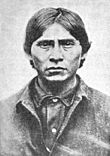
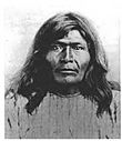
Famous Apache leaders like Cochise and Geronimo had connections to the San Mateo Mountains in Socorro County. Vicks Peak is named after Victorio. He was an Apache leader whose lands included much of southern New Mexico. Victorio is known for refusing to move in 1879. He led his warriors for two years before he was killed. Many Apaches respect him as much as Geronimo or Cochise.
The most famous outlaw with ties to the area might be the Apache Kid. His supposed grave is in the Apache Kid Wilderness. Stories about his actions and disappearance are very popular in southwestern folklore. Native Americans continued to live in the San Mateo Mountains even into the 1900s. In 1919, a writer named Aldo Leopold found an abandoned Native American hunting camp there.
- Cultural or Historic Figures with Ties to Socorro County
-
The Apache Kid is the namesake for a Wilderness area in the Cibola National Forest.
-
Vicks Peak in the San Mateo Mountains is named for Victorio, an Apache warrior and chief.
-
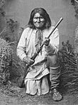
Geronimo (Goyaałé), a Bedonkohe Apache; kneeling with rifle, 1887.
-
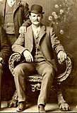
Butch Cassidy poses in the Wild Bunch group photo, Fort Worth, Texas, 1901.


Mining and Ranching
After the Apache Wars, people rushed to the mountains looking for gold, silver, and copper. This was when many non-Native Americans started to use the area. Today, you can barely see the old mining sites because they have collapsed or are hidden by plants.
While miners searched for riches, ranchers brought thousands of sheep and cattle to stockyards in Magdalena. Magdalena was connected to Socorro by train. The last regularly used cattle trail in the United States was 125 miles long. It stretched westward from Magdalena. This trail was called the Magdalena Livestock Driveway, or the "Beefsteak Trail" by cowboys. It was used from 1865 until 1971, when trucks took over from cattle drives.
Geography of Socorro County
Socorro County covers about 6,649 square miles. Most of this is land (6,647 square miles), with a small amount of water (2.1 square miles). It is the second-largest county in New Mexico by size.
The elevation in Socorro County changes a lot. It ranges from about 4,528 feet (1,380 meters) along the Rio Grande river. It goes up to 10,784 feet (3,287 meters) at the top of South Baldy peak. This peak is in the Magdalena Mountains.
Mountain Ranges and Sky Islands
The southern part of the Rocky Mountains extends into New Mexico and Socorro County. Several mountain ranges are found throughout the county. The Forest Service manages parts of four ranges: the Bear, Datil, Magdalena, and San Mateo Mountains. Most of these mountains are within the Cibola National Forest.
These mountain ranges, along with Ladron Peak, are called "sky islands." This means they are like isolated mountains that rise above the surrounding desert. They have different climates and ecosystems than the land around them.
Neighboring Counties
Socorro County shares borders with several other counties:
- Cibola County – to the northwest
- Valencia County – to the north
- Torrance County – to the northeast
- Lincoln County – to the east
- Sierra County – to the south
- Catron County – to the west
Protected Natural Areas
Socorro County is home to several important protected areas:
- Bosque del Apache National Wildlife Refuge
- Sevilleta National Wildlife Refuge
- Cibola National Forest (part of it)
- National System of Public Lands managed by the BLM’s Socorro Field Office (part of it)
- El Camino Real de Tierra Adentro National Historic Trail (part of it)
- Salinas Pueblo Missions National Monument (part of it)
People and Population
| Historical population | |||
|---|---|---|---|
| Census | Pop. | %± | |
| 1860 | 5,787 | — | |
| 1870 | 6,603 | 14.1% | |
| 1880 | 7,875 | 19.3% | |
| 1890 | 9,595 | 21.8% | |
| 1900 | 12,195 | 27.1% | |
| 1910 | 14,761 | 21.0% | |
| 1920 | 14,061 | −4.7% | |
| 1930 | 9,611 | −31.6% | |
| 1940 | 11,422 | 18.8% | |
| 1950 | 9,670 | −15.3% | |
| 1960 | 10,168 | 5.1% | |
| 1970 | 9,763 | −4.0% | |
| 1980 | 12,566 | 28.7% | |
| 1990 | 14,764 | 17.5% | |
| 2000 | 18,078 | 22.4% | |
| 2010 | 17,866 | −1.2% | |
| 2020 | 16,595 | −7.1% | |
| U.S. Decennial Census 1790-1960 1900–1990 1990-2000 2010 |
|||
In 2010, there were 17,866 people living in Socorro County. About 7,014 households and 4,349 families called it home. The county had about 2.7 people per square mile.
Most people in the county (75.1%) were white. About 11.7% were American Indian, and 48.5% were of Hispanic or Latino background. The average age of people living here was 36.9 years old.
Nature, Fun, and Visitors

Socorro County has many different natural areas. These include mountains, grasslands, and marshes. This means it's home to a huge variety of plants and animals! The county has 826 different kinds of wildlife. This includes 14 types of amphibians, 60 types of reptiles, 336 types of birds, and 96 types of mammals.
Wildlife in Socorro County
Some of the animals you might find here are coyotes, deer, elk, pronghorn antelope, bighorn sheep, and black bears. There are also mountain lions, wild turkeys, and many kinds of birds like the Mexican spotted owl and quail.
Wilderness Areas
Socorro County has three special Wilderness areas. These are places where the land is kept wild and undeveloped. The Apache Kid Wilderness and the Withington Wilderness Areas are both in the San Mateo Mountains. The Bosque del Apache Wilderness is part of the National Wildlife Refuge. These wild lands offer amazing chances to see nature, enjoy the outdoors, and explore deep into the backcountry.
Outdoor Activities and Tourism
The tall mountains, hidden canyons, beautiful forests, and diverse wildlife make Socorro County a great place for outdoor fun. You can go picnicking, hiking, backpacking, watching wildlife, horseback riding, and hunting. In fact, the four biggest elk ever found in New Mexico were hunted in Socorro County and the Datil Mountains.
Many visitors to the Cibola National Forest enjoy hiking and seeing the natural sights. The Bosque del Apache National Wildlife Refuge hosts a special event every November called the Festival of the Cranes. This festival celebrates the arrival of Sandhill cranes and other birds that migrate there for the winter. Sometimes, rare whooping cranes can also be seen at the Bosque del Apache.
- Wildlife in Socorro County, New Mexico
-
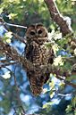
Socorro County contains thousands of acres of critical habitat for the threatened Mexican spotted owl.
-
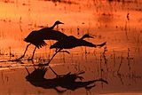
Sandhill cranes at Bosque del Apache National Wildlife Refuge during the Festival of the Cranes.
-
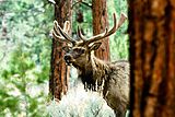
Socorro County is home to healthy populations of elk.
-
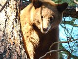
A black bear in the Cibola National Forest.
-
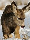
A mule deer fawn in the snow.
-
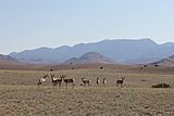
A pronghorn herd standing in front of the Magdalena Mountains.


All these natural attractions help make tourism strong in Socorro County. In 2011, visitors spent about $47.4 million here. Just outdoor recreation brought in over $4 million in both 2010 and 2011. Tourism also creates jobs and brings in tax money for the county.
Towns and Communities

City
- Socorro (This is the main town and county seat.)
Village
Other Communities
Socorro County has many smaller communities. Some are called "census-designated places" (CDPs), which are areas identified by the census bureau. Others are unincorporated, meaning they don't have their own local government. There are also some historic "ghost towns" where people used to live but don't anymore.
Census-designated places
Unincorporated communities
Populated Places
- Bingham
- Sabinal
Ghost towns
- Adobe
- Alamillo Pueblo
- Bosquecito
- Canta Recio
- Carthage
- Contadero
- Council Rock
- Field
- Kelly
- Pueblito de la Parida
- Paraje
- Park City
- Pilabó
- Qualacu
- Riley
- Rosedale
- San Felipe
- San Marcial
- San Pascual Pueblo
- San Pedro
- Senecú
- Tajo
- Tokay
- Val Verde
Education
Children in Socorro County attend schools in several different school districts:
- Belen Consolidated Schools
- Carrizozo Municipal Schools
- Corona Municipal Schools
- Magdalena Municipal Schools
- Mountainair Public Schools
- Socorro Consolidated Schools
See also
 In Spanish: Condado de Socorro para niños
