
South Baldy (New Mexico) facts for kids
Quick facts for kids South Baldy |
|
|---|---|

South Baldy is the snowcapped mountain peak seen in the distance to right center
|
|
| Highest point | |
| Elevation | 10,789 ft (3,288 m) NAVD 88 |
| Prominence | 3,803 ft (1,159 m) |
| Geography | |

South Baldy
Location in New Mexico
|
|
| Parent range | Magdalena Mountains |
| Topo map | USGS South Baldy (NM) |
| Climbing | |
| Easiest route | road |
South Baldy is the tallest mountain in the Magdalena Mountains. These mountains are located in central New Mexico, in the United States. It's a big landmark you can see from far away! The mountain is part of the Magdalena Ranger District of the Cibola National Forest. It sits about 9 miles (15 km) south of Magdalena and 18 miles (30 km) west of Socorro.
South Baldy is also close to some interesting science places. It is just north of the Langmuir Laboratory for Atmospheric Research. This lab is part of the New Mexico Institute of Mining and Technology. You can also find the Magdalena Ridge Observatory Interferometer nearby.
Getting to South Baldy
It is fairly easy to reach the top of South Baldy. There is a dirt road that goes right up to the Langmuir Laboratory. You can use this road to get close to the summit.
Hiking Trails
If you prefer hiking, there are trails too. You can start from a campground in Water Canyon. This canyon is on the northeast side of the mountain range. A trail follows Forest Road 406 and then Trail 10. This path goes up Copper Canyon to the main ridge of the mountains.
Once you are on the main ridge, you will join Trail 8. This is called the North Baldy Trail. It follows the top of the ridge. A short walk south on this trail, and a little bit of off-trail climbing, will take you to the very top of South Baldy.
Fun Facts About South Baldy
South Baldy is a popular spot for a special event. Each year, there is a mountain bike race that goes up the Langmuir Road. This race is part of the "Tour of Socorro."
Even though South Baldy is not the very highest mountain in New Mexico, it stands out a lot. This is because the land around it is much lower. It is the sixth most topographically prominent peak in the state. This means it rises very high above its surroundings.
Images for kids
-
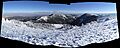
The eastern view from the summit of South Baldy.
-
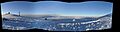
The western view from the summit of South Baldy.
