Catron County, New Mexico facts for kids
Quick facts for kids
Catron County
|
|
|---|---|

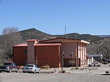
Catron County Courthouse in Reserve
|
|

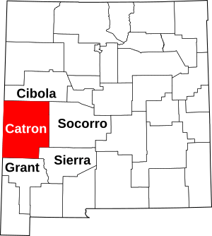
Location within the U.S. state of New Mexico
|
|
 New Mexico's location within the U.S. |
|
| Country | |
| State | |
| Founded | February 25, 1921 |
| Named for | Thomas B. Catron |
| Seat | Reserve |
| Largest village | Reserve |
| Area | |
| • Total | 6,929 sq mi (17,950 km2) |
| • Land | 6,924 sq mi (17,930 km2) |
| • Water | 5.5 sq mi (14 km2) 0.08%% |
| Population
(2020)
|
|
| • Total | 3,579 |
| • Density | 0.52/sq mi (0.20/km2) |
| Time zone | UTC−7 (Mountain) |
| • Summer (DST) | UTC−6 (MDT) |
| Congressional district | 2nd |
Catron County is a large county in the state of New Mexico, United States. In 2020, about 3,579 people lived there. This makes it the third-least populated county in New Mexico. The main town and county seat is Reserve. Catron County is the biggest county in New Mexico by land area.
Contents
History of Catron County
People have lived in the Catron County area for a very long time. Some of the earliest settlements in North America were here.
Ancient Cultures
During the Clovis culture period (around 10,999 BC to 8,000 BC) and the Folsom tradition period (around 7,999 BC to 5,999 BC), the Ake Site near Datil was a busy place. Bat Cave, near Horse Springs, was used around 3,500 BC.
The Mogollon culture people, known for their beautiful art, lived in the Catron County area from about AD 1000 to 1130. They are famous for their Mimbres pottery.
Spanish and Mexican Rule
In the 1500s, Spanish explorers and settlers arrived. In 1598, they claimed the area as part of Santa Fé de Nuevo México. This was a province of New Spain in the Americas.
Mexico became independent from Spain in 1821. The region then became part of the Territory of New Mexico under Mexican rule.
Becoming Part of the U.S.
After the Mexican–American War, Mexico gave this region to the U.S. in 1848. This was part of the Treaty of Guadalupe Hidalgo. The territory officially became a U.S. state in 1912.
Mining and Old West Figures
In 1880, Sergeant James C. Cooney found silver and gold in the mountains of Catron County. He was later killed by Chiricahua Apache warriors. His burial place is known as Cooney's Tomb.
The mountains and canyons here were good hiding spots for Apache warriors. Famous leaders like Cochise and Geronimo used to hide in the county. In 1880, Buffalo Soldiers led by Sergeant George Jordan fought and defeated Apache warriors in the Battle of Fort Tularosa. Later, in 1884, sheriff Elfego Baca became a local hero after a famous shootout.
The area also attracted well-known outlaws. In the mid-1880s, Butch Cassidy and his Wild Bunch gang hid at a ranch near Alma. The outlaw Tom Ketchum also lived in Catron County around this time.
County Formation
Catron County was officially created in 1921. It was named after Thomas B. Catron, who helped New Mexico become a state. He was also New Mexico's first U.S. senator.
In the late 1970s, a large art project called The Lightning Field brought national attention to Quemado.
Geography of Catron County
Catron County covers a total area of about 6,929 square miles. Most of this is land, with a small amount of water.
New Mexico's Largest County
Catron County is the largest county in New Mexico by area. It is almost 7,000 square miles, which is bigger than four U.S. states! Even though it's huge, only about 3,400 people live here. This makes it very spread out, like the old Wild West. There are actually more elk (about 12,000) than people in the county!
National Forests and Towns
Parts of the Gila National Forest, the Apache National Forest, and the Cibola National Forest are within Catron County. The town of Reserve, the county seat, got its name because it was near these "forest reserves." There are no traffic lights in the entire county. When people take driving tests in Reserve, they have to set up a portable stop light!
Catron County is on the border with Arizona. It offers the shortest route between Albuquerque and cities like Phoenix or Tucson.
Natural Features
Catron County has a volcanic area called Burning Mountain. Until recently, it was warm enough to create steam after it rained. The Apache people may have used it for healing. The county also has the Red Hill Volcanic Field and the Plains of San Agustin.
Mountains
- Black Mountain
- Black Range
- Datil Mountains
- Diablo Range
- Gallo Mountains
- Mangas Mountains
- Mogollon Mountains
- Saliz Mountains
- San Francisco Mountains
- Tularosa Mountains
- Whitewater Baldy
Bodies of Water
- San Francisco River
- Tularosa River
- Rio Salado
- Middle Fork Hot Springs
- Jordan Hot Springs (New Mexico)
- Turkey Creek Hot Springs
- Quemado Lake
- Zuni Salt Lake
Forests
- Apache-Sitgreaves National Forest
- Blue Range Wilderness
- Cibola National Forest
- Gila Wilderness
- Gila National Forest
- Whitewater Canyon National Forest Recreation Area
Neighboring Counties
- Cibola County - north
- Socorro County - east
- Sierra County - southeast
- Grant County - south
- Greenlee County, Arizona - west
- Apache County, Arizona - west
National Protected Areas
- Apache National Forest (part)
- Cibola National Forest (part)
- Gila Cliff Dwellings National Monument
- Gila National Forest (part)
People of Catron County
Population Changes
The population of Catron County has changed over the years:
| Historical population | |||
|---|---|---|---|
| Census | Pop. | %± | |
| 1930 | 3,282 | — | |
| 1940 | 4,881 | 48.7% | |
| 1950 | 3,533 | −27.6% | |
| 1960 | 2,773 | −21.5% | |
| 1970 | 2,198 | −20.7% | |
| 1980 | 2,720 | 23.7% | |
| 1990 | 2,563 | −5.8% | |
| 2000 | 3,543 | 38.2% | |
| 2010 | 3,725 | 5.1% | |
| 2020 | 3,579 | −3.9% | |
| U.S. Decennial Census 1790–1960 1900–1990 1990–2000 2010 |
|||
2010 Census Information
In 2010, there were 3,725 people living in Catron County. Most people (about 89.8%) were white. About 2.7% were American Indian, and 19.0% of the population was of Hispanic or Latino background.
The average age of people in the county was 55.8 years old.
Points of Interest
- Ake Site - This is an ancient place near Datil. It's one of the oldest inhabited sites in the American Southwest. People lived here during the Clovis and Folsom periods, thousands of years ago.
- Bat Cave - This cave was once covered by an ancient inland sea. In the 1940s and 50s, scientists found stone tools and even very old popcorn here! This shows people lived here as early as 3600 BCE.
- Bearwallow Park
- Bearwallow Mountain Lookout Cabins and Shed - These buildings were constructed in 1940. They are part of the historic structures in the Gila National Forest.
- Black Mountain Lookout Cabin
- Catwalk National Recreation Trail - This trail follows an old water system used for a mining town. Thousands of visitors enjoy walking on the Catwalk each year.
- Cooney's Tomb - Located near Alma, this is a large boulder that marks the burial spot of James C. Cooney. He was a miner killed by Apaches in 1880.
- El Caso Lake
- El Caso Lookout Complex - Built in 1934, this was one of three forest fire lookouts built in Catron County.
- Gila Cliff Dwellings National Monument
- Gila Wilderness
- Glenwood State Trout Hatchery
- Mangas Mountain Lookout Complex
- Mogollon Historic District - Mogollon was a successful mining town with many historic buildings.
- Mogollon Baldy Lookout Cabin
- Mogollon Pueblo
- The Lightning Fields - This is a huge outdoor art installation by Walter De Maria, covering 640 acres.
- Tularosa River Site and Tularosa Ranger Station - This area has over 500 ancient rock carvings (petroglyphs) and a historic U.S. Forest Service building from the 1920s.
- Whitewater Canyon National Forest Recreation Area
- Zuni Salt Lake and Sanctuary - For thousands of years, the Pueblo people have traveled to Zuni Salt Lake to gather salt for cooking and ceremonies. Old roads lead from the lake to ancient pueblo sites.
Communities
Village
- Reserve (county seat)
Census-designated places
- Alma
- Apache Creek
- Aragon
- Cruzville
- Datil
- Escudilla Bonita
- Glenwood
- Homestead
- Lower Frisco
- Luna
- Middle Frisco
- Mogollon
- Pie Town
- Pleasanton
- Quemado
- Rancho Grande
- Rivers
Unincorporated communities
Education
School districts in Catron County include:
- Quemado Independent Schools
- Reserve Independent Schools
Notable People
- Elfego Baca, a famous sheriff and folk hero.
- Agnes Morley Cleaveland, a writer and cattle rancher.
- Jerry D. Thompson, a historian who grew up in Quemado.
- Beverly Magennis, a tile artist and author.
See also
 In Spanish: Condado de Catron para niños
 | Jewel Prestage |
 | Ella Baker |
 | Fannie Lou Hamer |

