
Datil, New Mexico facts for kids
Quick facts for kids
Datil, New Mexico
|
|
|---|---|

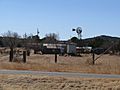
Datil viewed from the northwest
|
|

Datil, New Mexico
Location in New Mexico
|
|
| Country | United States |
| State | New Mexico |
| County | Catron |
| Area | |
| • Total | 1.87 sq mi (4.85 km2) |
| • Land | 1.87 sq mi (4.84 km2) |
| • Water | 0.00 sq mi (0.01 km2) |
| Elevation | 7,441 ft (2,268 m) |
| Population
(2020)
|
|
| • Total | 50 |
| • Density | 26.74/sq mi (10.32/km2) |
| Time zone | UTC−7 (Mountain (MST)) |
| • Summer (DST) | UTC−6 (MDT) |
| Area code(s) | 575 |
| GNIS feature ID | 2584087 |
Datil is a small community in Catron County, New Mexico, in the United States. It's known as a census-designated place, which means it's a special area defined by the government for counting people. In 2020, about 50 people lived there.
Datil is located where two main roads meet: U.S. Route 60 and New Mexico State Road 12. It sits near the edge of the large Cibola National Forest. A famous science spot called the Very Large Array is also close by.
History of Datil
Datil got its name from the nearby Datil Mountains. The word "Datil" comes from the Spanish word dátil, which means "date." This name probably came from the fruit-like look of the seedpods on local yucca plants.
The town was once part of an important route called the Magdalena Stock Driveway. This driveway had wells every ten miles. Ranchers used it from the late 1800s to the mid-1900s. They would guide their cattle from Springerville, Arizona, all the way to a railroad in Magdalena.
Today, the Bureau of Land Management takes care of a campground called Datil Well Campground. It's located where one of those old wells used to be.
Where is Datil?
Datil is found at the crossing of U.S. Route 60 and New Mexico State Road 12. To the east of Datil, you'll find the wide San Agustin Plains. This is also where the amazing Very Large Array is located. The village of Magdalena is also to the east.
If you head southwest on State Road 12, you'll find several small communities. The highway goes past a local landmark called Horse Mountain, which is a tall peak. It then continues through the small town of Apache Creek. Finally, it reaches Reserve, which is the main town for the county.
U.S. 60 travels west from Datil. It goes through the northwest part of the Cibola National Forest. After leaving the forest, you'll find the town of Pie Town.
-
Buildings in Datil
-
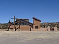
The Church of the Nativity of the Blessed Virgin Mary


People in Datil
Datil is a small community. The number of people living there is counted by the government every ten years.
| Historical population | |||
|---|---|---|---|
| Census | Pop. | %± | |
| 2020 | 50 | — | |
| U.S. Decennial Census | |||
Schools in Datil
The schools in Datil are part of the Quemado Schools district. Datil Elementary School is a special kind of school. It's a two-room schoolhouse where students of different ages learn together in the same classroom.
Older students, those in middle and high school, go to Quemado Elementary and High School. This school teaches students from kindergarten all the way through 12th grade.
Datil's Weather
Datil has a climate with warm summers and cold winters. Here's a look at the weather data from 1905 to 1951:
| Climate data for Datil, New Mexico. (1905-1951) | |||||||||||||
|---|---|---|---|---|---|---|---|---|---|---|---|---|---|
| Month | Jan | Feb | Mar | Apr | May | Jun | Jul | Aug | Sep | Oct | Nov | Dec | Year |
| Record high °F (°C) | 68 (20) |
68 (20) |
74 (23) |
86 (30) |
92 (33) |
95 (35) |
98 (37) |
99 (37) |
96 (36) |
86 (30) |
79 (26) |
71 (22) |
99 (37) |
| Mean daily maximum °F (°C) | 44.7 (7.1) |
49.1 (9.5) |
57.1 (13.9) |
63.7 (17.6) |
72.0 (22.2) |
82.7 (28.2) |
83.1 (28.4) |
81.9 (27.7) |
79.2 (26.2) |
68.7 (20.4) |
56.9 (13.8) |
46.7 (8.2) |
65.5 (18.6) |
| Mean daily minimum °F (°C) | 10.9 (−11.7) |
17.8 (−7.9) |
21.5 (−5.8) |
28.6 (−1.9) |
32.0 (0.0) |
41.4 (5.2) |
50.2 (10.1) |
49.5 (9.7) |
40.1 (4.5) |
30.1 (−1.1) |
18.3 (−7.6) |
12.1 (−11.1) |
29.4 (−1.4) |
| Record low °F (°C) | −26 (−32) |
−21 (−29) |
−8 (−22) |
5 (−15) |
11 (−12) |
23 (−5) |
31 (−1) |
33 (1) |
24 (−4) |
9 (−13) |
−10 (−23) |
−18 (−28) |
−26 (−32) |
| Average precipitation inches (mm) | 0.55 (14) |
0.50 (13) |
0.44 (11) |
0.53 (13) |
0.70 (18) |
0.74 (19) |
2.30 (58) |
2.77 (70) |
1.72 (44) |
0.85 (22) |
0.61 (15) |
0.70 (18) |
12.42 (315) |
| Average snowfall inches (cm) | 3.6 (9.1) |
8.8 (22) |
3.0 (7.6) |
3.0 (7.6) |
0.6 (1.5) |
0.0 (0.0) |
0.0 (0.0) |
0.0 (0.0) |
0.0 (0.0) |
0.3 (0.76) |
2.3 (5.8) |
10.0 (25) |
31.6 (80) |
| Source: The Western Regional Climate Center | |||||||||||||
See also
 In Spanish: Dátil (Nuevo México) para niños
