Gila Cliff Dwellings National Monument facts for kids
|
Gila Cliff Dwellings National Monument
|
|
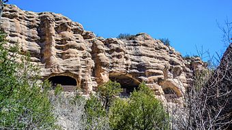
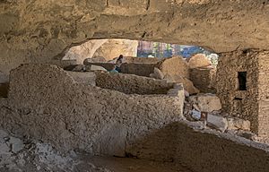
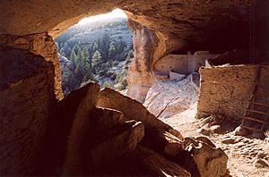
Gila Cliff Dwellings as seen from a gorge below
|
|
| Nearest city | Silver City, New Mexico |
|---|---|
| Area | 533 acres (216 ha) |
| Visitation | 41,519 (2016) |
| Website | Gila Cliff Dwellings National Monument |
| NRHP reference No. | 66000472 |
Quick facts for kids Significant dates |
|
| Added to NRHP | October 15, 1966 |
| Designated NMON | November 16, 1907 |
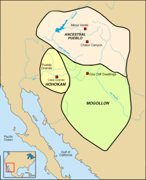
The Gila Cliff Dwellings National Monument is a special place in southwest New Mexico. It was created to protect ancient homes built into cliffs by the Mogollon people. These homes are found in the Gila Wilderness, near where the Gila River begins.
This national monument covers about 533 acres (2.16 square kilometers). President Theodore Roosevelt officially set it aside on November 16, 1907. It is located in the very southern part of Catron County. You can visit the monument by driving about 45 miles (72 kilometers) north from Silver City, New Mexico on NM 15.
Contents
Exploring the Gila Cliff Dwellings
Archaeologists, who study ancient cultures, believe this area was the northern edge of where the Mogollon people lived. The Gila Cliff Dwellings National Monument has two main ruin sites, plus many smaller ones. These are all located within the Gila Wilderness inside the Gila National Forest.
The land here is rugged and dry. It has steep canyons carved by small rivers and tall flat-topped hills called mesas. The elevation ranges from about 5,700 to 7,300 feet (1,737 to 2,225 meters) above sea level. You can see trees like Ponderosa pine, Gambel's oak, and Douglas fir. The area's geology comes from ancient volcanic activity, which is why there are still hot springs here today.
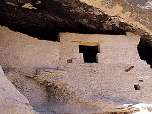
The monument protects the remains of a Mimbres Culture community, a group within the Mogollon people. The most famous dwellings are built inside natural caves high up in Cliff Dweller Canyon. The people used these caves to create connected rooms. Another important site, the TJ Ruins, sits on a bluff overlooking the Gila River. Experts think the Mogollon people lived here from about 1275 to the early 1300s. No one knows for sure why they left their homes.
Archaeologists have found 46 rooms in the five caves in Cliff Dweller Canyon. They believe 10 to 15 families lived there. The TJ Ruins, also called the "Heart-Bar Site," are mostly still buried and waiting to be explored.
Other ruins in the area include Javalina House and West Fork Ruin. The Cosgrove Ruin, with 11 rooms, is along the middle fork of the Gila River. Scientists used Dendrochronology (tree ring dating) to find out that the wood used in the dwellings was cut between 1276 and 1287. The region offered plenty of food from farming, gathering, and hunting.
To visit the main cliff dwellings, you need to hike a well-marked 1-mile (1.6-kilometer) loop trail. The path includes several bridges over a stream. The hike takes about an hour and goes from an elevation of 5,695 feet (1,736 meters) to 5,875 feet (1,791 meters).
How the Dwellings Were Discovered
Local Native American tribes always knew about these ruins. However, the first European to see the Gila Cliff Dwellings was Henry B. Ailman in 1878. He and his friends were trying to avoid jury duty. So, they went on a prospecting trip to the Gila River and stumbled upon the site.
Over the next few years, many people came to study the dwellings. In the 1890s, the Hill brothers opened a resort at the nearby Gila Hot Springs. They started offering the first tours to the ruins for their guests.
In 1906, a law called the Antiquities Act was passed. This law allowed the U.S. President to protect historic and prehistoric sites by making them national monuments. In December 1906, a forest supervisor named R. C. McClure suggested that the Gila Cliff Dwellings should be protected. He wanted to stop people from taking artifacts from the site.
Several mummified bodies were found at the Gila Cliff Dwellings over time. Sadly, many were lost to people who took them for private collections. In 1912, a burial ground was found, and a mummified infant, nicknamed "Zeke," was discovered. This discovery became famous and brought more visitors to the monument. "Zeke" is the only known mummy from the monument that the Smithsonian acquired.
The first park ranger for the monument was Doc Campbell, an early settler. He helped the National Park Service teams keep the ruins stable. His family still guides trips from their nearby Campbells Post.
The monument's management moved from the U.S. Department of Agriculture to the National Park Service in 1933. Later, in 1962, President Kennedy added about 375 acres (1.52 square kilometers) to the monument. This addition included the TJ site and more wilderness. In 1975, the U.S. Forest Service took over administration, but it returned to the National Park Service in 2003.
What You Can See and Do
There is a museum and visitor center at the monument, located near the TJ Ruins. The U.S. Forest Service and the National Park Service work together to run it. The museum has exhibits of artifacts from both the Apache and Mogollon cultures. These items were found in the wilderness and at the monument.
One interesting item on display is a bracelet made from Glycymeris clam shells. A student park ranger, Charles Grymko, found it. These shells likely came from the Gulf of California through trade. They were then carved by Hohokam artisans in an ancient village called Snaketown in Arizona. The bracelet then traveled up the Gila River through trade to the Mogollon community.
Besides the cliff dwellings, you can also visit nearby hot springs and other ruin sites. There are many hiking trails in the national forest. You can also enjoy fishing along the Gila River and in the Gila Wilderness.
More to Explore
- List of national monuments of the United States
- National Register of Historic Places listings in Catron County, New Mexico
See also
 In Spanish: Monumento Nacional de las Casas del Acantilado de Gila para niños
 | Mary Eliza Mahoney |
 | Susie King Taylor |
 | Ida Gray |
 | Eliza Ann Grier |


