
Gila River facts for kids
Quick facts for kids Gila River |
|
|---|---|

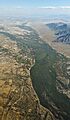
The river in the Gila Box Canyon in eastern Arizona
|
|

Map of the Gila River watershed
|
|
| Country | United States |
| State | Arizona |
| State | New Mexico |
| Physical characteristics | |
| Main source | Confluence of East and West Forks Grant County, New Mexico 5,551 ft (1,692 m) 33°10′47″N 108°12′22″W / 33.17972°N 108.20611°W |
| River mouth | Colorado River Yuma, Arizona 118 ft (36 m) 32°43′11″N 114°33′19″W / 32.71972°N 114.55528°W |
| Length | 649 mi (1,044 km) |
| Basin features | |
| Basin size | 58,200 sq mi (151,000 km2) |
| Tributaries | |
The Gila River is a long river, about 649-mile (1,044 km) (1,044 km), that flows through New Mexico and Arizona in the United States. It's a tributary of the Colorado River, meaning it flows into the Colorado River. The Gila River drains a large, dry area of nearly 60,000 square miles (160,000 km2) (155,000 km²). Most of this area is in the U.S., but a small part reaches into northern Sonora, Mexico.
People have lived along the Gila River for at least 2,000 years. They built advanced farming communities long before Europeans arrived in the 1500s. However, European Americans didn't settle permanently in the Gila River area until the mid-1800s.
In the 1900s, people built many dams and structures to control floods and move water. Because of this, the Gila River now carries much less water to the Colorado River than it used to. These projects have changed the river valley from a dry desert into irrigated farmland. They also provide water for over five million people, mostly in the Phoenix and Tucson areas, who live in the river's watershed.
Contents
Geography of the Gila River
The Gila River starts in western New Mexico. Its source is in Sierra County, on the western side of the Continental Divide. This is a mountain ridge that separates rivers flowing to the Pacific Ocean from those flowing to the Atlantic.
Where Does the Gila River Flow?
The river flows southwest through the Gila National Forest. It also passes by the Gila Cliff Dwellings National Monument. Then, it turns west into Arizona, flowing past the town of Safford. After going through canyons in the Gila Mountains, the river is held back by the Coolidge Dam. This dam creates San Carlos Lake.
After leaving the mountains, the Gila River enters the valley southeast of Phoenix. Here, it crosses the Gila River Indian Reservation. Because so much water is taken for irrigation, the river often dries up in this area. West of Phoenix, the river turns sharply south around the Gila Bend Mountains. Then it swings west again near Gila Bend. It flows southwest between the Gila Mountains and the Laguna and Muggins ranges. Finally, it empties into the Colorado River at Yuma, Arizona.
What Rivers Join the Gila?
Many smaller rivers, called tributaries, join the Gila River. The East and West Forks of the Gila River combine to form the main river in New Mexico. Near Safford, the San Francisco River and the San Simon River join it. Further downstream, the San Carlos River flows into San Carlos Lake.
At Winkelman, Arizona, the San Pedro River joins the Gila. Then, the Santa Cruz River joins it south of Casa Grande. The Salt River, which is the Gila's biggest tributary, joins it in the Phoenix area. Further west, the Agua Fria and Hassayampa Rivers also join the Gila from the north.
How Big is the Gila River's Watershed?
Most of the Gila River's watershed is in the United States. However, the starting points of two tributaries, the San Pedro and Santa Cruz Rivers, are in Mexico. About 2.8% of the Gila's 58,200-square-mile (151,000 km2) watershed is in Mexico. About 5.7% is in New Mexico, and the largest part, 91.5%, is in Arizona.
History of the Gila River

The Pima people, who call themselves "Akimel O'odham" (meaning "river people"), have lived along the Gila River for a very long time. They are known as the Keli Akimel O'odham, or "Gila River People." Their traditional way of life is centered around the river, which they consider sacred. The word "Gila" might come from a Spanish version of a Yuma word, "Hah-quah-sa-eel," which means "running water which is salty."
Ancient Civilizations Along the River
Ancient people like the Hohokam built large, complex societies along the Middle Gila River and Salt River. This was between 600 and 1450 AD. These groups relied heavily on farming that used irrigation. They built over 200 miles (320 km) of canals to bring water to their crops. The Mogollon culture lived along the upper Gila River during much of the same time. Their settlements included places like the Gila Cliff Dwellings National Monument.
Early European Explorers
The first European to possibly see the Gila River was Spanish explorer and missionary Juan de la Asunción in 1538. He traveled north along one of its tributaries. In 1540, Hernando de Alarcón sailed up the Colorado and Gila Rivers. His maps showed the river with names like Miraflores.


The Gila River and American Expansion
During the Mexican–American War in 1846, General Stephen Watts Kearny and his soldiers marched along the Gila River. They were guided by Kit Carson. The Mormon Battalion followed them, building a wagon trail along the river.
After the war, the Treaty of Guadalupe-Hidalgo in 1848 made the Gila River part of the border between the United States and Mexico. This changed in 1853 with the Gadsden Purchase, which moved the U.S. border further south. Starting in 1871, Mormon settlers moved into the Gila River valley near present-day Phoenix. They used the Gila, Salt, and San Pedro Rivers for irrigation and built several settlements.
A Famous Escape Story
In 1944, during World War II, 25 German prisoners of war made a daring escape from a camp in Arizona. They dug a 178-foot (54 m) tunnel out of the Papago Park Prisoner of War Camp. Their plan was to use the Gila River to reach the Colorado River and then Mexico. They even built a collapsible kayak inside the camp!
However, their map was wrong. The Gila River, shown as a flowing blue river on the map, was mostly dry. All the men were eventually caught, but some stayed free for over a month. This story shows how much the Gila River's flow can change.

Dams and Water Diversions

The main dam on the Gila River is the Coolidge Dam, which creates San Carlos Lake. Another important dam is the Painted Rock Dam near Gila Bend. Many smaller dams have been built on the Gila and its tributaries to divert water. These include the Gillespie Dam, which broke during a flood in 1993.
Many large dams in the Gila River system were built by the U.S. Bureau of Reclamation. This agency also built most of the big dams in the Colorado River basin. Other dams are owned by local water companies or Native American tribes.
Why is the Gila River Often Dry?
The Gila River and its main tributary, the Salt River, used to flow with a lot of water all year. But now, because so much water is taken for farming and cities, both rivers are often dry. Below Phoenix, the Gila River is usually just a trickle or completely dry. However, after heavy rains, both rivers can carry huge amounts of water.
A long time ago, large boats could travel on the Gila River from its mouth almost to Phoenix. Smaller boats could go even further. The river used to be wide, from 150 to 1,200 feet (46 to 366 m), and deep, from 2 to 40 feet (0.61 to 12.19 m). The river's natural flow was about 1,800 cubic feet per second (51 m3/s) at its mouth. Today, its average flow near the mouth is only about 247 cubic feet per second (7.0 m3/s).
Because so much water is taken from the Gila River system, the Central Arizona Project was built. This project brings water from the Colorado River to help supply the basin.
Protecting the Upper Gila River
The upper part of the Gila River, especially in New Mexico, still flows freely without dams. There have been plans to build dams or divert water from this section. However, these plans have faced strong opposition. The upper Gila River has been called one of the nation's most endangered rivers because of these proposed projects.
Recreation on the Gila River


You can boat on the Gila River between Virden, New Mexico, and Solomon, Arizona, during spring snowmelt or after heavy storms. The river flows through beautiful canyons and has sections of whitewater rapids. Because it's in a desert, the river's flow can change very quickly. It can have sudden floods and then dry up fast. The Salt River, a tributary of the Gila, has even more challenging whitewater.
Boating and fishing are popular on San Carlos Lake and other reservoirs in the basin. These include Lake Pleasant and Theodore Roosevelt Lake. The Gila River system is home to 36 types of fish. These include largemouth bass, sunfish, channel catfish, flathead catfish, and the rare Gila trout.
Other Names for the Gila River
The Gila River has been known by many different names throughout history:
- Akee-mull
- Apache de Gila
- Brazo de Miraflores
- Cina`ahuwipi (Chemehuevi language)
- Hah-quah-sa eel (Yuma language)
- Hela River
- Jila River
- Rio Azul
- Rio Gila
- Rio de las Balsas
- Rio del Nombre Jesus
- Rio del los Apostoles
- Zila River
- Xila River
- Keli Akimel
Images for kids
-
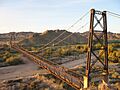
The McPhaul Suspension Bridge spans the Gila in Yuma County.
-
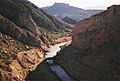
The Gila River near Coolidge Dam in Arizona.
-
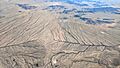
This patch of desert south of Buckeye, Arizona, drains east and west to the Gila River.
-
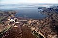
Painted Rock Dam in central Arizona, with its usually dry reservoir nearly full after heavy runoff in 2005.
-
Gila River at Komatke, Arizona, in the Gila River Indian Community, just south of Phoenix.
-
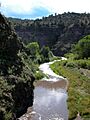
Middle Fork of the Gila River, SW New Mexico.
-
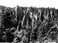
Rock spires above the East Fork of the Gila River, Gila Wilderness.
See also
 In Spanish: Río Gila para niños
