Continental divide facts for kids
A continental divide is like a giant natural boundary on a continent. It separates which way water flows. On one side, all the rivers and streams eventually flow into one ocean or sea. On the other side, they flow into a different ocean or sea. Sometimes, water on one side might flow into a special area called an endorheic basin. This means the water stays in a lake or a dry area and doesn't reach the ocean.
It can be tricky to find the exact end points of a continental divide where it meets the coast. This is because the borders between different oceans or seas are not always clearly defined. Also, if a divide meets an endorheic basin, like the Great Divide Basin in Wyoming, the divide might split and go around the basin.
Contents
Major Continental Divides Around the World
Africa
The most important continental divide in Africa is the Congo-Nile Divide. It separates the areas where water flows into the Nile River from where it flows into the Congo River. This divide goes through the region of the African Great Lakes.
Between the Congo River and the Sahara Desert, a huge area drains into Lake Chad. This lake is endorheic, meaning its water doesn't reach the ocean. This creates a break in the divide between the Atlantic Ocean and the Mediterranean Sea.
In East Africa, the divide between the Mediterranean Sea and the Indian Ocean is also broken by endorheic lake systems in the East African Rift. In southern Africa, the divide between the Atlantic and Indian Oceans winds around the watersheds of the Congo, Zambezi, Limpopo, and Orange Rivers. The Okavango River ends in the Kalahari Desert, which is another endorheic area.
Antarctica
Antarctica usually isn't thought of as having a continental divide. This is because it gets very little snow, and the entire continent is surrounded by the Southern Ocean. However, the Transantarctic Mountains do separate the huge ice streams. These streams drain West Antarctica towards the Pacific Ocean and the Ronne Ice Shelf. They also drain East Antarctica towards the Atlantic and Indian Oceans and the Ross Ice Shelf.
Australia
In Australia, the Great Dividing Range mostly separates rivers. Rivers on one side flow to the eastern coast and the Pacific Ocean. Rivers on the other side flow westward into the Murray–Darling Basin and then to the Southern Ocean.
Australia has fewer clear ocean boundaries and not as many tall mountain ranges. This makes it harder to define one single, clear divide. Also, much of Australia's interior drains into the Lake Eyre Basin, which is endorheic.
Eurasia
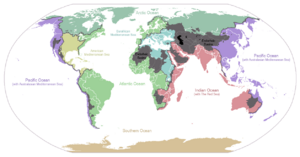
Eurasia has several divides. These depend on how you define different "oceans" and seas, like the Mediterranean Sea, Atlantic Ocean, Arctic Ocean, Baltic Sea, Black Sea, and North Sea.
Here are some examples:
- Asia:
- In Himachal Pradesh, India, the divide separates water flowing to the Arabian Sea (from the Sutlej and Indus rivers).
- Near Lake Baikal, Russia, the divide separates water flowing to the Kara Sea and Laptev Sea (from the Yenisei and Lena rivers).
- In the Urals, Russia, the divide separates water flowing to the Caspian Sea (from the Volga River) and the Arctic Ocean (from the Pechora and Ob rivers).
- The Tibetan Plateau and Himalayas separate water flowing to the Indian Ocean and the Pacific Ocean.
- In Uttarakhand, India, the divide separates water flowing to the Bay of Bengal (from the Yamuna and Ganges rivers).
- Europe-Asia:
- The divide between the Don and Volga rivers separates water flowing to the Black Sea and the Caspian Sea.
- Europe:
- The European Watershed has a special "triple divide" at Lunghin Pass in the Central Eastern Alps. From this spot, water can flow to three different places: the North Sea (via the Rhine River), the Black Sea (via the Danube River), and the Adriatic Sea (part of the Mediterranean, via the Po River).
North America
North America has several important continental divides:
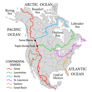
- The Arctic Divide: This divide, along with others, creates two main watersheds for the Arctic Ocean: the Arctic Ocean watershed itself and the Hudson Bay watershed. This divide was very important in history. Before 1778, it was a barrier for travel. But then the Methye Portage was found, which opened up Arctic rivers for fur traders. It became part of a trade route across the continent. It also marked the northern border of Rupert's Land, which was the trading area of the Hudson's Bay Company.
- The Continental Divide of the Americas: Also known as the Great Divide, this is the most famous one. It separates water flowing to the Pacific Ocean from water flowing to the Atlantic Ocean and Arctic Ocean. It starts in Alaska on the Seward Peninsula. Then it runs through western Canada along the top of the Rocky Mountains. It goes through famous places like Glacier National Park, Yellowstone National Park, and Rocky Mountain National Park. It continues into New Mexico, then follows the top of Mexico's Sierra Madre Occidental mountains, all the way to the tip of South America. The Panama Canal crosses this divide, as do the two outlets of Isa Lake in Yellowstone National Park.
- The Eastern Continental Divide: This divide separates water flowing to the Gulf of Mexico from water flowing directly to the Atlantic Ocean. It runs from the border of New York and Pennsylvania along the Appalachian Mountains down to the tip of Florida. The city of Atlanta is located right on top of this divide.
- The Northern Divide (Laurentian Divide): This divide separates water flowing to the Atlantic Ocean from water flowing to Hudson Bay. The western part of this divide, from Glacier National Park to the Great Lakes watershed, used to be the northern border of the Louisiana Purchase. It also marked the border between the United States and British North America until the 49th parallel became the border in 1818. In Canada, it historically marked the southern border of the Hudson's Bay Company's fur trading area. The eastern part still marks part of the border between Quebec and Labrador. This divide goes through very flat land, especially in North Dakota. Because of this, many travelers are surprised when they see a sign marking the divide.
- The St. Lawrence River Divide: This divide separates the Great Lakes Basin from the rest of the Atlantic Ocean watershed. Two canals cross this divide. The Chicago Sanitary and Ship Canal crosses the Chicago Portage and connects Lake Michigan to the Mississippi River watershed. The Erie Canal connects Lake Erie to the Hudson River watershed. In the past, there were more canals, like the Ohio and Erie Canal, but most of them are no longer used.
South America
In South America, the Continental Divide of the Americas runs along the Andes Mountains. South of Lácar Lake, there are many lakes on the eastern side of the Andes. These lakes actually drain to the Pacific Ocean, even though they are on the "Atlantic" side of the highest peaks. These lakes in Patagonia were formed by glaciers during the Pleistocene glaciations. Before these ice ages, the water from these areas used to flow to the Atlantic Ocean.
See also
In Spanish: Divisoria continental para niños
 | Jackie Robinson |
 | Jack Johnson |
 | Althea Gibson |
 | Arthur Ashe |
 | Muhammad Ali |


