
Ohio and Erie Canal facts for kids
Quick facts for kids Ohio and Erie Canal |
|
|---|---|

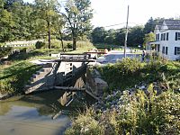
Part of the Ohio and Erie canal, 1902
|
|
| Location | Independence and Valley View, Cuyahoga County, Ohio |
| Specifications | |
| Length | 308 miles (496 km) |
| Locks | 152 (originally 146) |
| Original number of locks | 146 |
| Status | closed |
| Geography | |
| Start point | Cleveland, Ohio on the lake Erie |
| End point | Portsmouth, Ohio |
|
Ohio and Erie Canal Historic District
|
|
| Location | Independence and Valley View, Cuyahoga County, Ohio |
| Area | 24.5 acres (99,000 m2) |
| Built | 1825 |
| NRHP reference No. | 66000607 |
| Significant dates | |
| Added to NRHP | November 13, 1966 |
| Designated NHLD | November 13, 1966 |

The Ohio and Erie Canal was a long waterway built in Ohio during the 1820s and early 1830s. It connected Akron to the Cuyahoga River near Lake Erie in Cleveland. A few years later, it reached the Ohio River near Portsmouth. This canal also linked up with other canal systems in Pennsylvania.
The canal was used to move goods from 1827 to 1861. After that, railroads became popular, and people didn't need the canal for shipping as much. From 1862 to 1913, the canal mostly provided water for factories and towns. In 1913, big floods damaged many parts of the canal system, and most of it was no longer used.
Today, much of the canal is looked after by the National Park Service or the Ohio Department of Natural Resources. People use these parts for fun activities like walking and biking. Some industries still get water from the canal. Special parts of the canal are saved, like the Ohio and Erie Canal Historic District, which is a very important historical site.
Contents
Building Ohio's Canals
Ohio became a state in 1803. At that time, only about 50,000 people lived there. They were spread out and had no easy way to move goods out of the state. Farmers could only sell their crops locally. Large factories didn't exist because there was no way to transport their products.
Why Did Ohio Need Canals?
As early as 1787, important leaders like George Washington and Thomas Jefferson talked about building canals. They thought a canal linking Lake Erie to the Ohio River would be good for the whole country. In 1807, Ohio's first Senator, Thomas Worthington, asked Congress to study the idea.
In 1810, DeWitt Clinton worked on building the Erie Canal in New York. He tried to get national help for a canal connecting Lake Erie to the Hudson River. When that didn't work, he asked Ohio's leaders for help. In 1812, Ohio's government agreed that connecting the Great Lakes to the Hudson River was important for the nation. However, President Madison was against it, and the War of 1812 stopped the talks.
In 1816, New York's Governor Clinton told Ohio that his state would build the Erie Canal alone. He asked Ohio to join in. Ohio's Governor Worthington tried to make a deal with Clinton. But building canals was very expensive. So, Ohio's government waited three years. Finally, in 1822, Ohio decided to pay for its own canal system.
Planning the Canal Routes
On January 31, 1822, Ohio's government decided to hire an engineer. They also appointed people to plan the canal system quickly. They set aside $6,000 for this work.
James Geddes, an engineer from New York, was hired. Most people in Ohio lived between Cleveland and Cincinnati. So, the main canal needed to serve these areas. But no single river flowed along this path. Canals are easier and cheaper to build along river valleys. This made designing the system tricky.
The canal had to cross the Scioto and Miami river valleys. This meant raising the canal very high. Water from those rivers could not be used to fill the canal. So, the canal was split into two main parts. The Ohio and Erie Canal connected Cleveland to Portsmouth. The Miami and Erie Canal connected Cincinnati to Dayton. The Miami and Erie Canal was later extended to the Maumee River at Toledo.
You can find copies of the original maps for Ohio's canals online. They are at the Ohio Department of Natural Resources.
Building the Canal (1825–1832)
On February 4, 1825, Ohio's government passed a law to build the canals. The Canal Commission could borrow $400,000 in 1825. They could borrow up to $600,000 each year after that. The money borrowed would be paid back between 1850 and 1875.
Work on the canal began on July 4, 1825. This happened at Licking Summit near Newark, Ohio.
The canals were planned to be at least 40 feet wide at the top. They were 26 feet wide at the bottom. They also had to be at least 4 feet deep. Often, they were built even wider or deeper. It was sometimes cheaper to build one side and let the water fill up to a nearby hillside. Rivers could also be dammed to create long, calm sections of water. These could be used as part of the canal if towpaths were added. When it made sense, like for locks or narrow rocky parts, the minimum widths were followed.
Workers were hired for many jobs. These included clearing land, digging ditches, building embankments, and making locks.
At first, many contractors were new to this kind of work. They were not always reliable. It was common for many people to bid on a job. The chosen contractor might have bid too low. They would often leave without paying their workers. This made laborers afraid to work on the canal. But as the process improved, more reliable contractors were hired.
Workers first earned $0.30 per day. They were also given a small drink of whiskey. As the work continued, and when workers were hard to find, they could earn up to $15 per month. At that time, cash money was rare in Ohio. Many people traded goods instead of using money. Working on the canal was appealing, and many farmers left their land to join the effort.
On July 3, 1827, the first canal boat left Akron. It traveled through 41 locks and over 3 aqueducts. It covered 37 miles of canal. The boat arrived in Cleveland on July 4. Canal boats moved slowly, about 3 miles per hour. But they could carry 10 tons of goods. This was much more efficient than wagons on bumpy dirt roads.

Over the next five years, more parts of the canal opened. The entire canal was finished in 1832.
- 1828: The canal opened from Akron to Massillon, Ohio. It was 65 miles long.
- 1829: It opened from Massillon to Dover, Ohio. The canal was 93 miles long.
- 1830: It opened from Dover to Newark, Ohio. The canal was 177 miles long.
- 1831: It opened from Newark to Chillicothe, Ohio. The canal was 258 miles long.
By 1832, the Ohio and Erie Canal was complete. The whole canal system was 308 miles long. It had 146 lift locks and rose 1,206 feet in elevation. There were also five smaller canals, called feeder canals. These added 24.8 miles and 6 more locks to the system.
The canal's locks were numbered starting from the Lower Basin in Akron. Lock 1 North was north of the basin. Lock 1 South was south of the basin. The Pennsylvania and Ohio Canal also joined at this basin.
How the Canal Was Used (1833–1913)
The canals were very successful from the 1830s to the early 1860s. They made the most money between 1852 and 1855. In the 1840s, Ohio was the third richest state. Much of this growth was thanks to the canal.
After the Civil War, it became clear that railroads would take over the canal's business. From 1861 to 1879, Ohio leased its canals to private companies. These companies made money from the few boats still using the canal. They also sold water to factories and towns. When the state took back the canals in 1879, they found them in poor condition. Also, state lands around the canals had been sold illegally. In many places, canals were filled in. New railroad tracks were often built where the canals used to be. Some state land was even given away for free to people with political connections. Still, the state made some money into the early 1900s. This came from selling water rights and land around the canals.
When the Canal Was Abandoned
After making a lot of money in the 1850s, the canal's costs started to be higher than its income. This was due to rising maintenance costs. By 1911, most of the southern part of the canal was no longer used. The Great Dayton Flood of 1913 brought a huge amount of rain to Ohio. This caused widespread flooding. Reservoirs overflowed into the canals. Aqueducts were destroyed, banks washed away, and most locks were ruined. In Akron, Lock 1 was even blown up with dynamite to let floodwater escape.
Famous People and the Canal
When he was a teenager in 1847, James Garfield worked on the canal. He was a "hoggee," meaning he drove mules to pull barges. He fell into the canal many times while working. After getting sick, Garfield decided to go to college instead. He later became a U.S. President.
The Canal Today

The Ohio and Erie Canal Historic District is a 24.5-acre historic area. It was named a National Historic Landmark in 1966. This district includes a four-mile section of the canal in Valley View. It has three locks, the Tinkers Creek Aqueduct, and two other structures.
A section of the Ohio & Erie Canal in Summit County, Ohio still has water. It is used to supply water to local industries. After the 1913 flood, a few parts of the canal continued to carry goods to nearby factories. Another watered section goes from the Station Road Bridge in Brecksville north into Valley View and Independence. These are all suburbs of Cleveland.
In 1989, the section of the canal from the Brecksville Dam to Rockside Road was given to the National Park Service. This became part of the Cuyahoga Valley National Park.
The Cleveland Metroparks now manage the canal lands from the Cuyahoga Valley National Park to the end of the canal. They also manage the surrounding Ohio & Erie Canal Reservation.
The part of the Ohio & Erie Canal still owned by the Ohio Department of Natural Resources (ODNR) is in southern Summit County. It runs from downtown Akron to Barberton, about 12 miles. This section includes a feeder canal from the Tuscarawas River. It also has flood control systems at the Portage Lakes.
A small team of ODNR operators in Akron maintains the Ohio & Erie Canal. They also manage its feeder reservoirs. The canals were not built to handle large amounts of stormwater. Most of the problems with dirt buildup and erosion today are from stormwater being incorrectly piped into the canals over the years.
In late 1996, the canal from Zoar to Cleveland was named a National Heritage Corridor. Many communities, groups, businesses, and people worked together to make this happen.
You can find a map showing the canal lands online. It is available from the Ohio Department of Natural Resources.
Places to See Along the Canal

- Alexander's (or Wilson's) Mill
- Boston Store
- Canal Visitor Center
- Frazee House
- St. Helena III Historic Boat Ride in Canal Fulton
- Mustill Store
- Peninsula Depot
- Station Road Bridge
- Tinkers Creek Aqueduct
- Fort Laurens - Ohio's only fort from the American Revolutionary War
- Restored canal town Historic Roscoe Village Roscoe Village (Coshocton, Ohio)
- Monticello III Canal Ride on Mudport Basin Roscoe Village (Coshocton, Ohio)
- Restored Walhonding Aqueduct Bridge Roscoe Village (Coshocton, Ohio)
Other Canals Connected to the Ohio and Erie Canal
The Ohio and Erie Canal first linked Akron and Lake Erie at Cleveland. It then stretched all the way to the Ohio River. Later, other canals were built to connect it with the Pennsylvania and Ohio Canal and other parts of Eastern Ohio.
| Name | Description |
|---|---|
| Columbus Feeder | Lockbourne, Columbus, Franklin County |
| Granville Feeder | Granville, Licking County |
| Hocking Valley | Carroll, Lancaster, Fairfield County; Logan, Hocking County; Nelsonville, Athens, Athens County |
| Muskingum Side Cut | Dresden, Zanesville, Muskingum County; McConnelsville, Morgan County; Marietta, Washington County |
| Pennsylvania and Ohio Canal | Akron, Summit County; Kent, Ravenna, Portage County; Warren, Trumbull County; Youngstown, Mahoning County; Ohio; Lawrence; Beaver, Beaver County; Allegheny, Pennsylvania |
| Sandy and Beaver Canal a.k.a. Tuscarawas Feeder |
Bolivar, Tuscarawas County; Hanoverton, Lisbon, East Liverpool, Columbiana County; Glasgow, Beaver County, Pennsylvania |
| Walhonding Canal | Roscoe Village, Coshocton County; Brinkhaven, Knox County |
Towpath Trail Landmarks
A path for bikes and walkers, called the Towpath Trail, was built. It generally follows the old Ohio and Erie Canal route. This trail goes through parts of Cuyahoga and Summit Counties. The Cleveland Metroparks and Akron/Summit County Metroparks helped build it. The northernmost part in Cuyahoga County is still being built. Many other trails connect to it, leading to interesting places in the park systems.
-
Restored canal Twelve Mile Lock 38, Cuyahoga Valley National Park
-
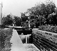
Peninsula Lock 29,
Peninsula Aqueduct steel trusses
over Cuyahoga River in background. -
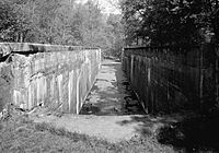
Deep Lock 28 as it existed in 1985


| Mile Post |
ID # |
Name |
Type |
Municipality |
County |
Description |
|---|---|---|---|---|---|---|
| 0 | 44 North | Cuyahoga River Sloop | Lock | Cleveland | Cuyahoga | Merwin Street between James street and West street |
| 43 North | Lock | Cleveland | Cuyahoga | Sherwin Williams, James and West, Merrwin and Vineyard | ||
| Weigh | Lock | Cleveland | Cuyahoga | Seneca a.k.a. West 3rd. street | ||
| 3 | 42 North | Lock | Cleveland | Cuyahoga | relocated to 42A | |
| 3 | 42A North | Weigh and Guard | Lock | Cleveland | Cuyahoga | near Grasselli chemical company, Dille street and Independence road |
| 5 | 41 North | RathBuns | Lock | Cuyahoga | near Austin Powder Works, Harvard Road, near Jennings Road | |
| 8 | 40 North | Willow | Lock | Cuyahoga Heights | Cuyahoga | off Canal Road, near I-77 |
| Mill Creek | Aqueduct | Cuyahoga Heights | Cuyahoga | carries canal over Mill Creek (Cuyahoga River) off Canal Road | ||
| GNIS | GNIS 17 Cleveland South topographic map | |||||
| Bridge | Cuyahoga | Rockside Road | ||||
| TrailHead | Cuyahoga | CVSR | ||||
| 11 | MilePost Marker | Cuyahoga | ||||
| 11 | 39 North | Lock | Independence | Cuyahoga | ||
| GNIS | GNIS 16 Shaker Heights topographic map | |||||
| 12 | MilePost Marker | Cuyahoga | ||||
| Bridge | Cuyahoga | Hillside Road | ||||
| TrailHead | Cuyahoga | CVSR-Canal Visitor Center, 7104 Canal Road and Hillside Road | ||||
| 12 | 38 North | Lock | Valley View | Cuyahoga | Canal Visitor Center | |
| Cuyahoga County | Tinkers Creek Road | |||||
| 13 | MilePost Marker | Cuyahoga | ||||
| Tinkers Creek | Aqueduct | Cuyahoga | carries canal over Tinkers Creek (Cuyahoga River) | |||
| Bridge | Cuyahoga | Alexander Road-Pleasant Valley Road | ||||
| 14 | 37 North | Lock | Cuyahoga | Alexander's Mill | ||
| Mill | Cuyahoga | Alexanders (a.k.a. Wilsons) | ||||
| 14 | MilePost Marker | Cuyahoga | ||||
| Trailhead | Cuyahoga | Sagamore Road | ||||
| 15 | MilePost Marker | Cuyahoga | ||||
| 16 | MilePost Marker | Cuyahoga | ||||
| GNIS | GNIS 15 Northfield topographic map | |||||
| 17 | 36 North | Pinery Dam and Feeder | Lock | Summit | ||
| Bridge | Summit | SR-82 | ||||
| 17 | MilePost Marker | Summit | ||||
| TrailHead | Summit | Station Road bridge to CVSR-Brecksville | ||||
| 19 | 35 North | Kettlewell Whiskey | Lock | Summit | ||
| 18 | MilePost Marker | Summit | ||||
| Trail | Summit | Old Carriage | ||||
| Trail | Summit | Old Carriage Connector | ||||
| 19 | MilePost Marker | Summit | ||||
| 20 | 34 North | Red | Lock | Summit | Jaite in southwestern Northfield Township | |
| TrailHead | Red Lock | |||||
| Bridge | Summit | Highland Road | ||||
| 20 | MilePost Marker | Summit | ||||
| 20.5 | 33 North | Wallace | Lock | Summit | in Boston Township | |
| 21 | MilePost Marker | Summit | ||||
| 21 | 32 North | Boston | Lock | Summit | Boston Township | |
| Summit | Boston Mills Road | |||||
| TrailHead | Summit | CVSR-Boston Store | ||||
| Bridge | Summit | I-271 Southbound | ||||
| Bridge | Summit | I-271 Northbound | ||||
| Bridge | Summit | I-80 Westbound | ||||
| Bridge | Summit | I-80 Eastbound | ||||
| 22 | MilePost Marker | Summit | ||||
| Summit | Stumpy Basin | |||||
| 22 | 31 North | Lonesome | Lock | Summit | was in Boston Township | |
| 23 | MilePost Marker | Summit | ||||
| 23 | 30 North | Peninsula Feeder | Lock | Peninsula | Summit | |
| Peninsula | TrailHead | Peninsula | Summit | CVSR | ||
| 23 | 29 North | Peninsula | Lock | Peninsula | Summit | |
| Peninsula | Aqueduct | Peninsula | Summit | carried canal over Cuyahoga River | ||
| Bridge | Summit | SR-303 | ||||
| 24 | MilePost Marker | Summit | ||||
| 25 | 28 North | Deep | Lock | Peninsula | Summit | at 17 feet, the deepest lock along the canal |
| TrailHead | Summit | Deep Lock Quarry | ||||
| 25 | MilePost Marker | Summit | ||||
| 26 | MilePost Marker | Summit | ||||
| 27 | 27 North | Johnny Cake | Lock | Summit | ||
| Furnace Run | Aqueduct | Summit | carried canal over Furnace Run (Cuyahoga River) | |||
| 27 | MilePost Marker | Summit | ||||
| Bridge | Summit | Bolanz Road | ||||
| 28 | MilePost Marker | Summit | ||||
| Summit | Beaver Marsh | |||||
| 28 | 26 North | Pancake | Lock | Summit | ||
| Ira | TrailHead | Summit | CVSR | |||
| 29 | MilePost Marker | Summit | ||||
| 28 | 25 North | Mudcatcher | Lock | Summit | ||
| 30 | 24 North | Niles | Lock | Summit | ||
| Bridge | Summit | Yellow Creek (Cuyahoga River) | ||||
| 30 | MilePost Marker | Summit | ||||
| Bridge | Summit | Bath Road | ||||
| Indian Mound | TrailHead | Summit | CVSR | |||
| GNIS | GNIS 14 Akron West topographic map | |||||
| 32 | 23 North | Booth port | Lock | Summit | sewer pipe | |
| 32 | 22 North | Booth port | Lock | Summit | Merriman sewer pipe | |
| 33 | 21 North | Lock | Summit | sewer over-flow | ||
| 20 North | Lock | Summit | train abutments | |||
| 19 North | Black Dog Crossing | Lock | Summit | near Hickory and Memorial | ||
| 35 | 18 North | Lock | Summit | |||
| 36 | 17 North | Lock | Summit | |||
| 36 | 16 North | Lock | Summit | |||
| 36 | 15 North | Akron Mustill Store | Lock | Akron | Summit | |
| 36 | 14 North | Lock | Akron | Summit | North Street | |
| 36 | 13 North | Lock | Akron | Summit | ||
| 36 | 12 North | Lock | Akron | Summit | ||
| 36 | 11 North | Lock | Akron | Summit | ||
| 36 | 10 North | Lock | Akron | Summit | ||
| 9 North | Lock | Akron | Summit | north of Market street | ||
| 8 North | Lock | Akron | Summit | tunnel | ||
| 37 | 7 North | Lock | Akron | Summit | middle tunnel | |
| 37 | 6 North | Lock | Akron | Summit | tunnel below parking deck North of Mill street | |
| 37 | 5 North | Lock | Akron | Summit | tunnel | |
| 37 | 4 North | Lock | Akron | Summit | tunnel | |
| 37 | 3 North | Lock | Akron | Summit | South Main street | |
| 38 | 2 North | Lock | Akron | Summit | Water street | |
| 38 | 1 North | Lock | Akron | Summit | West Exchange street | |
| 0 | Portage landing | Lock | Akron | Summit | Portage lakes, Manchester Road | |
| 1 South | Wolf creek | Lock | Barberton | Summit | Snyder avenue | |
| Wolf creek | Aqueduct | Barberton | Summit | Snyder avenue | ||
| GNIS | GNIS 13 Doylestown topographic map | |||||
| 2 South | Lock | New Franklin | Stark | Center Road | ||
| 3 South | Lock | New Franklin | Stark | Center Road | ||
| GNIS | GNIS 12 Canal Fulton topographic map | |||||
| 4 South | Lock | Canal Fulton | Stark | |||
| GNIS | GNIS 11 Massillon topographic map | |||||
| Trailhead | Massillon | Stark | ||||
| GNIS | GNIS 10 Bolivar topographic map | |||||
| GNIS | GNIS 9 Thornville topographic map | |||||
| GNIS | GNIS 8 Millersport topographic map | |||||
| 5 South | Lock | |||||
| 5A South | Lock | |||||
| Lock | ||||||
| Lock | ||||||
| 31 South | Lock | |||||
| 32 South | Lock | |||||
| 33 South | Lock | |||||
| North 20 | Lock | |||||
| North 19 | Lock | |||||
| North 18 | Lock | |||||
| Lock | ||||||
| Lock | ||||||
| North 1 | Lock | |||||
| North 0 | Minthorn | Lock | Newark | Licking | ||
| South 0 | Pugh | Lock | ||||
| South 1 | King Watson | Lock | Canal Road | |||
| GNIS | GNIS 7 Baltimore topographic map | |||||
| 196 | South 2 | David Miller's White Mill | Lock | Baltimore | Fairfield | |
| 197.4 | South 3 | Norris Mill | Lock | Baltimore | Fairfield | |
| South 4 | Short Level | Lock | Baltimore | Fairfield | ||
| 198 | South 5 | Dry Dock | Lock | Baltimore | Fairfield | |
| 198.3 | South 6 | Mulnix Mill | Lock | Baltimore | Fairfield | |
| 198.8 | South 7 | Wells Mill | Lock | Basil, Ohio | ||
| 200 | South 8 | Bibler | Lock | Baltimore | Fairfield | Previous town Basil, Ohio. Behind the water treatment plant. |
| 208 | South 9 | Lock | Carroll | Fairfield | ||
| South 10 | Lock | Carroll, Ohio | Fairfield | |||
| 206 | South 11 | Lock | Violet Township | Fairfield County, Ohio | Upper Lockville | |
| South 12 | Tennis/Tennat | Lock | Lockville | |||
| South 13 | Rowe | Lock | Lockville | |||
| South 14 | Smallwood | Lock | ||||
| South 15 | Fickle Mill Short Level | Lock | Lockville | |||
| South 16 | Rover Short Level | Lock | Lockville | |||
| South 17 | Swimmer's | Lock | Lockville | |||
| South 18 | Creek | Lock | Lockvile | |||
| 208 | Walnet Creek Guard | Lock | ||||
| GNIS | GNIS 6 Canal Winchester topographic map | |||||
| 210 | South 19 | Chaney's Mill | Lock | Canal Winchester | ||
| 210 | South 20 | Woolen | Lock | Canal Winchester | Gender Road | |
| South 21 | Lock | Canal Winchester | near Glenarda Farms, Groveport Road | |||
| George's Culvert | Canal Winchester | |||||
| South 22 | Groveport | Lock | Groveport | Franklin | Behind the Groveport Aquatic Recreation Center. | |
| GNIS | GNIS 5 Lockbourne topographic map | |||||
| 217 | South 23 | Lock | Lockbourne | Franklin | Canal Road | |
| 217 | South 24 | Lock | Lockbourne | Franklin | Canal Road | |
| 217 | South 25 | Lock | Lockbourne | Franklin | Canal Road | |
| 217.5 | South 26 | Lock | Lockbourne | Franklin | ||
| 218 | South 27 | Lock | Lockbourne | Franklin | Canal Road | |
| 218 | South 28 | Lock | Lockbourne | Franklin | under railroad track bed | |
| South 29 | Lock | |||||
| South 30 | Lock | Lockbourne | Franklin | Lockmeadows Park | ||
| GNIS | GNIS 4 Carroll topographic map | |||||
| GNIS | GNIS 3 Amanda topographic map | |||||
| GNIS | GNIS 2 Ashville topographic map | |||||
| GNIS | GNIS 1 New Philadelphia topographic map | |||||
| Columbus Feeder East Guard | Lock | |||||
| Columbus Feeder West Guard | Lock | |||||
| 226 | South 31 | Ashville Campbells Mill | Lock | |||
| 237 | South 32 | Aqueduct | Lock | Scioto River, West of Circleville | ||
| 237 | Circleville Feeder | Lock | Spunkytown | |||
| 238 | South 33 | Lock | Wayne Township | |||
| 238 | South 34 | Lock | Wayne Township | |||
| South 35 | Lock | Chillicothe, Ohio | ||||
| 256 | South 36 | Lock | Chillicothe, Ohio | |||
| 258 | South 37 | Lock | Chillicothe, Ohio | parking lot | ||
| South 38 | Fifth Street | Lock | Chillicothe, Ohio | |||
| 261 | South 39 | Upper Lunbeck | Lock | |||
| 261 | South 40 | Lower Lunbeck | Lock | Scioto Township | Pickaway | near Renick Lane 601 |
| South 41 | Tomlinsons | Lock | 3 Locks Road, South of Chillicothe | |||
| South 42 | Tomlinsons | Lock | ||||
| South 43 | Tomlinsons | Lock | ||||
| Tomlinsons Dam and Feeder Guard | Lock | |||||
| South 44 | Waverly | Lock | ||||
| 280 | South 45 | U Pee Pee | Lock | |||
| 280 | South 46 | L Pee Pee | Lock | |||
| 291 | South 47 | Howards | Lock | near Robers 18 mi Lock Farm | ||
| South 48 | Herod's | Lock | ||||
| South 49 | Rushs Brush Creek | Lock | ||||
| South 50 | Union Mills | Lock | ||||
| South 51 | Union Mills Moss | Lock | near Ohio State Route 239 | |||
| South 52 | Union Mills | Lock | ||||
| 305 | South 53 | Elbow | Lock | |||
| South 54 | Lock | Portsmouth | Scioto County | |||
| 308 | South 55 | Ohio River Terminal | Lock | West Portsmouth | Scioto County | near Old River Road, Portsmouth/Alexandria |
The canal travels through these counties in Ohio: Cuyahoga, Summit, Stark, Licking, Franklin, Fairfield, Pickaway, and Scioto.
