Knox County, Ohio facts for kids
Quick facts for kids
Knox County
|
|||
|---|---|---|---|

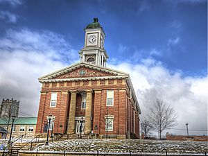
The Knox County Courthouse in 2013
|
|||
|
|||

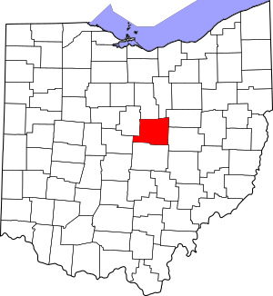
Location within the U.S. state of Ohio
|
|||
 Ohio's location within the U.S. |
|||
| Country | |||
| State | |||
| Founded | March 1, 1808 | ||
| Named for | Henry Knox | ||
| Seat | Mount Vernon | ||
| Largest city | Mount Vernon | ||
| Area | |||
| • Total | 530 sq mi (1,400 km2) | ||
| • Land | 525 sq mi (1,360 km2) | ||
| • Water | 4.1 sq mi (11 km2) 0.8%% | ||
| Population
(2020)
|
|||
| • Total | 62,721 | ||
| • Density | 118.3/sq mi (45.7/km2) | ||
| Time zone | UTC−5 (Eastern) | ||
| • Summer (DST) | UTC−4 (EDT) | ||
| Congressional district | 12th | ||
Knox County is a county in the state of Ohio, United States. In 2020, about 62,721 people lived here. The main city and county seat is Mount Vernon.
The county is named after Henry Knox. He was an important officer in the American Revolutionary War. Later, he became the first Secretary of War. Knox County is part of the Mount Vernon, OH area. It is also included in the larger Columbus-Marion-Zanesville, OH region.
Contents
Discovering Knox County's Past
Knox County was created in 1808. It was formed from parts of Fairfield County.
Exploring Knox County's Geography
Knox County covers about 530 square miles. Most of this area, about 525 square miles, is land. Only a small part, about 4.1 square miles, is water.
A big part of the county, about 58%, is farmland. Forests cover another 28% of the land. Most of Knox County has rolling hills and valleys. These are part of the Glaciated Allegheny Plateau. Some places in the county are over 1,400 feet above sea level.
Neighboring Counties
Knox County shares borders with several other counties:
- Richland County (to the north)
- Ashland County (to the far northeast)
- Holmes County (to the northeast)
- Coshocton County (to the east)
- Licking County (to the south)
- Delaware County (to the southwest)
- Morrow County (to the northwest)
Understanding Knox County's Population
The number of people living in Knox County has grown over time.
| Historical population | |||
|---|---|---|---|
| Census | Pop. | %± | |
| 1810 | 2,149 | — | |
| 1820 | 8,326 | 287.4% | |
| 1830 | 17,085 | 105.2% | |
| 1840 | 29,579 | 73.1% | |
| 1850 | 28,872 | −2.4% | |
| 1860 | 27,735 | −3.9% | |
| 1870 | 26,333 | −5.1% | |
| 1880 | 27,431 | 4.2% | |
| 1890 | 27,600 | 0.6% | |
| 1900 | 27,768 | 0.6% | |
| 1910 | 30,181 | 8.7% | |
| 1920 | 29,580 | −2.0% | |
| 1930 | 29,338 | −0.8% | |
| 1940 | 31,024 | 5.7% | |
| 1950 | 35,287 | 13.7% | |
| 1960 | 38,808 | 10.0% | |
| 1970 | 41,795 | 7.7% | |
| 1980 | 46,304 | 10.8% | |
| 1990 | 47,473 | 2.5% | |
| 2000 | 54,500 | 14.8% | |
| 2010 | 60,921 | 11.8% | |
| 2020 | 62,721 | 3.0% | |
| U.S. Decennial Census 1790–1960 1900–1990 1990–2000 2020 |
|||
In 2010, there were 60,921 people living in Knox County. Most people were white. About 1.2% of the population was of Hispanic or Latino background. The average age of people in the county was 38.3 years old.
Knox County's Economy
Agriculture is a big part of Knox County's economy. Farmers earn a lot from crops and livestock. Corn is the main crop grown here, followed by soybeans.
Mount Vernon, the county seat, has some major employers. These include Siemens Energy Inc. and Ariel Corporation. Both companies make parts for the natural gas industry.
Other important employers are Kenyon College in Gambier and Mount Vernon Nazarene University in Mount Vernon. The Kokosing Construction Company, near Fredericktown, is also a large employer.
Learning and Education
Knox County is home to two universities:
- Kenyon College
- Mount Vernon Nazarene University
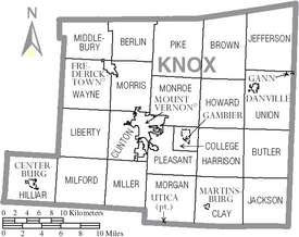
Communities in Knox County
Cities
- Mount Vernon (This is the county seat)
Villages
Townships
- Berlin
- Brown
- Butler
- Clay
- Clinton
- College
- Harrison
- Hilliar
- Howard
- Jackson
- Jefferson
- Liberty
- Middlebury
- Milford
- Miller
- Monroe
- Morgan
- Morris
- Pike
- Pleasant
- Union
- Wayne
Census-Designated Places
These are areas that are like towns but are not officially incorporated as cities or villages:
- Apple Valley
- Bladensburg
- Howard
- South Mount Vernon
Unincorporated Communities
These are smaller communities that are not officially part of a city or village:
Famous People from Knox County
Many well-known people have lived or worked in Knox County, including:
- Thomas Peter Akers, a United States Congressman
- Sean M. Decatur, a chemist and former president of Kenyon College
- Dan Emmett, who wrote the famous song "Dixie"
- George Hunt, who was the Attorney General for Illinois
- Paul Lynde, an actor known for Bewitched and Hollywood Squares
- Paul Newman, a famous actor
- Luke Perry, an actor
See also
 In Spanish: Condado de Knox (Ohio) para niños
 | Stephanie Wilson |
 | Charles Bolden |
 | Ronald McNair |
 | Frederick D. Gregory |


