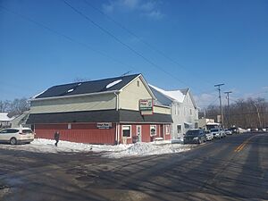
Howard, Ohio facts for kids
Quick facts for kids
Howard, Ohio
|
|
|---|---|

Howard, Ohio in 2022
|
|
| Country | United States |
| State | Ohio |
| County | Knox |
| Townships | Howard |
| Area | |
| • Total | 0.22 sq mi (0.58 km2) |
| • Land | 0.22 sq mi (0.58 km2) |
| • Water | 0.00 sq mi (0.00 km2) |
| Elevation | 910 ft (280 m) |
| Population
(2020)
|
|
| • Total | 246 |
| • Density | 1,098.21/sq mi (424.38/km2) |
| Time zone | UTC-5 (Eastern (EST)) |
| • Summer (DST) | UTC-4 (EDT) |
| ZIP code |
43028
|
| Area code(s) | 740 |
| FIPS code | 39-36512 |
| GNIS feature ID | 2628904 |
Howard is a small community located in Knox County, Ohio, United States. It is known as a census-designated place (CDP). A CDP is a special area that the government uses for gathering information about people, even though it's not officially a city or town.
In 2020, about 246 people lived in Howard. The community uses the ZIP Code 43028 for mail. You can find Howard along U.S. Route 36, which is a major road.
Howard's History and Name
The area where Howard is now was first called "Kinderhook." The name changed to "Howard" when a railroad line was built there. This happened because the railroad made it easier for people and goods to travel.
A post office opened in Howard in 1872. This helped the community grow and connect with other places.
Education and Local Life
Howard is home to East Knox High School. This is where many students in the area go to learn. The main offices for the East Knox Local School District are also located here.
A popular walking and biking path, the Kokosing Gap Trail, goes right through Howard. This trail is a great place for people to enjoy nature and get some exercise.
Who Lives in Howard?
The number of people living in Howard is counted every ten years by the United States Census Bureau. This helps us understand how communities are changing.
In 2020, the census showed that 246 people lived in Howard.
| Historical population | |||
|---|---|---|---|
| Census | Pop. | %± | |
| 2020 | 246 | — | |
| U.S. Decennial Census | |||
See also
 In Spanish: Howard (Ohio) para niños
 | Calvin Brent |
 | Walter T. Bailey |
 | Martha Cassell Thompson |
 | Alberta Jeannette Cassell |


