Coshocton County, Ohio facts for kids
Quick facts for kids
Coshocton County
|
|||
|---|---|---|---|

|
|||
|
|||

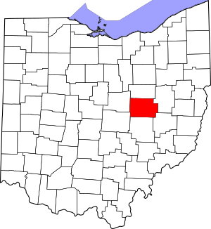
Location within the U.S. state of Ohio
|
|||
 Ohio's location within the U.S. |
|||
| Country | |||
| State | |||
| Founded | April 1, 1811 | ||
| Named for | "union of waters" or "black bear crossing" in Delaware (Lenape) language | ||
| Seat | Coshocton | ||
| Largest city | Coshocton | ||
| Area | |||
| • Total | 567 sq mi (1,470 km2) | ||
| • Land | 564 sq mi (1,460 km2) | ||
| • Water | 3.6 sq mi (9 km2) 0.6%% | ||
| Population
(2020)
|
|||
| • Total | 36,612 |
||
| • Density | 65/sq mi (25/km2) | ||
| Time zone | UTC−5 (Eastern) | ||
| • Summer (DST) | UTC−4 (EDT) | ||
| Congressional district | 12th | ||
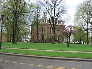
Coshocton County is a place in the state of Ohio, United States. It's like a big neighborhood or district within Ohio. In 2020, about 36,612 people lived here.
The main city and county seat is also called Coshocton. This county is part of the Appalachian region, which means it has hills and valleys.
Coshocton County was created on January 31, 1810. It was formed from parts of Muskingum and Tuscarawas Counties. It officially started working as a county in 1811.
The name "Coshocton" comes from the Delaware Indian language. It can mean "union of waters" or "black bear crossing." An early explorer, David Zeisberger, wrote about "Goschachgünk" in his diary in the 1780s. The whole county is part of the Coshocton, OH Micropolitan Statistical Area. This means it's a smaller city area with a central city and nearby communities.
Contents
Where is Coshocton County?
Coshocton County covers about 567 square miles. Most of this area, 564 square miles, is land. The rest, about 3.6 square miles, is water.
Neighboring Counties
Coshocton County shares its borders with several other counties:
- Holmes County to the north
- Tuscarawas County to the east
- Guernsey County to the southeast
- Muskingum County to the south
- Licking County to the southwest
- Knox County to the west
Who Lives in Coshocton County?
| Historical population | |||
|---|---|---|---|
| Census | Pop. | %± | |
| 1820 | 7,086 | — | |
| 1830 | 11,161 | 57.5% | |
| 1840 | 21,590 | 93.4% | |
| 1850 | 25,674 | 18.9% | |
| 1860 | 25,032 | −2.5% | |
| 1870 | 23,600 | −5.7% | |
| 1880 | 26,642 | 12.9% | |
| 1890 | 26,703 | 0.2% | |
| 1900 | 29,337 | 9.9% | |
| 1910 | 30,121 | 2.7% | |
| 1920 | 29,595 | −1.7% | |
| 1930 | 28,976 | −2.1% | |
| 1940 | 30,594 | 5.6% | |
| 1950 | 31,141 | 1.8% | |
| 1960 | 32,224 | 3.5% | |
| 1970 | 33,486 | 3.9% | |
| 1980 | 36,024 | 7.6% | |
| 1990 | 35,427 | −1.7% | |
| 2000 | 36,655 | 3.5% | |
| 2010 | 36,901 | 0.7% | |
| 2020 | 36,612 | −0.8% | |
| U.S. Decennial Census 1790–1960 1900–1990 1990–2000 2020 |
|||
In 2010, about 36,901 people lived in Coshocton County. There were about 14,658 households. Most people (97%) were white. About 1.1% were Black or African American. A small number were Asian or American Indian.
Many families lived in the county. About 53.7% of households were married couples. The average age of people living here was about 40.8 years old.
The average income for a household was around $39,469 per year. About 17% of the population lived below the poverty line. This included 26% of children under 18.
Amish and Mennonite Communities
In 2020, about 2,724 people in the county were part of the Amish and Mennonite communities. This was about 7.4% of everyone living there. These groups often live a simpler lifestyle.
Towns and Villages
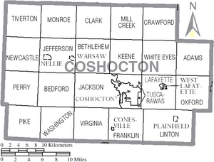
Coshocton County has one main city and several smaller villages and communities.
City
- Coshocton (This is the county seat, where the main government offices are.)
Villages
Townships
A township is a smaller area of land, often with a local government. Coshocton County has many townships:
- Adams
- Bedford
- Bethlehem
- Clark
- Crawford
- Franklin
- Jackson
- Jefferson
- Keene
- Lafayette
- Linton
- Mill Creek
- Monroe
- Newcastle
- Oxford
- Perry
- Pike
- Tiverton
- Tuscarawas
- Virginia
- Washington
- White Eyes
Census-Designated Places
These are areas that are like towns but don't have their own separate local government.
Unincorporated Communities
These are smaller places that are not officially part of a city or village.
See also
 In Spanish: Condado de Coshocton para niños
 | Delilah Pierce |
 | Gordon Parks |
 | Augusta Savage |
 | Charles Ethan Porter |


