Coshocton, Ohio facts for kids
Quick facts for kids
Coshocton, Ohio
|
|
|---|---|

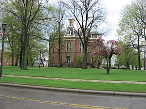
Public square surrounding the Coshocton County Courthouse
|
|

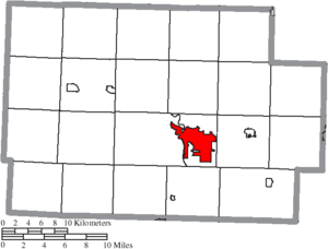
Location of Coshocton in Coshocton County
|
|
| Country | United States of America |
| State | Ohio |
| County | Coshocton |
| Established | 1811 |
| Area | |
| • Total | 8.17 sq mi (21.16 km2) |
| • Land | 8.00 sq mi (20.73 km2) |
| • Water | 0.17 sq mi (0.43 km2) |
| Elevation | 814 ft (248 m) |
| Population
(2020)
|
|
| • Total | 11,050 |
| • Estimate
(2023)
|
11,091 |
| • Density | 1,380.56/sq mi (533.07/km2) |
| ZIP code |
43812
|
| Area code(s) | 220 and 740 |
| FIPS code | 39-18868 |
| GNIS feature ID | 1085913 |
Coshocton is a city in Ohio, United States. It is the main city of Coshocton County. About 11,050 people lived there in 2020. Coshocton is located where the Walhonding River and the Tuscarawas River meet. These two rivers join to form the Muskingum River.
The city is home to Roscoe Village. This is a special place that shows what life was like during the canal era. It helps visitors learn about the area's history with canals. Coshocton was built on the site of an older village. This village was started by the Lenape people in the late 1770s.
Contents
Exploring Coshocton's History
The area around Coshocton has a long and interesting past. The Lenape people lived here for many years. Some Lenape leaders, like White Eyes, tried to make peace with the new United States. They signed a special agreement called the Treaty of Fort Pitt in 1778. This treaty aimed to keep the Lenape safe during the American Revolutionary War. It also meant they would help the American colonists.
However, not all groups followed the treaty. In 1781, a military leader named Colonel Daniel Brodhead led an attack. He destroyed a Lenape village near Coshocton. This event was part of a difficult time for the native people.
The American colonists first called the town "Tuscarawas." This name came from the nearby river. The town was officially planned in 1802. In 1811, it was renamed Coshocton. This happened when it became the main city for the county.
Understanding Coshocton's Geography
Coshocton is located in a scenic part of Ohio. The city covers an area of about 8.20 square miles (21.2 square kilometers). Most of this area is land, with a small part being water. The meeting of the Walhonding and Tuscarawas rivers is a key geographical feature.
Coshocton's Climate and Weather
The weather in Coshocton changes throughout the year. It has warm summers and cold winters. The city experiences all four seasons.
| Climate data for Coshocton, Ohio (1991–2020 normals, extremes 1915–present) | |||||||||||||
|---|---|---|---|---|---|---|---|---|---|---|---|---|---|
| Month | Jan | Feb | Mar | Apr | May | Jun | Jul | Aug | Sep | Oct | Nov | Dec | Year |
| Record high °F (°C) | 75 (24) |
76 (24) |
86 (30) |
93 (34) |
95 (35) |
103 (39) |
106 (41) |
106 (41) |
106 (41) |
92 (33) |
83 (28) |
77 (25) |
106 (41) |
| Mean daily maximum °F (°C) | 36.6 (2.6) |
40.3 (4.6) |
50.2 (10.1) |
63.1 (17.3) |
72.6 (22.6) |
80.0 (26.7) |
83.4 (28.6) |
82.2 (27.9) |
75.9 (24.4) |
64.5 (18.1) |
51.8 (11.0) |
41.0 (5.0) |
61.8 (16.6) |
| Daily mean °F (°C) | 28.3 (−2.1) |
31.1 (−0.5) |
39.8 (4.3) |
51.3 (10.7) |
61.1 (16.2) |
69.2 (20.7) |
72.9 (22.7) |
71.4 (21.9) |
64.6 (18.1) |
53.0 (11.7) |
41.8 (5.4) |
32.9 (0.5) |
51.4 (10.8) |
| Mean daily minimum °F (°C) | 19.9 (−6.7) |
22.0 (−5.6) |
29.5 (−1.4) |
39.4 (4.1) |
49.7 (9.8) |
58.3 (14.6) |
62.6 (17.0) |
60.7 (15.9) |
53.2 (11.8) |
41.6 (5.3) |
31.8 (−0.1) |
24.9 (−3.9) |
41.1 (5.1) |
| Record low °F (°C) | −24 (−31) |
−26 (−32) |
−6 (−21) |
9 (−13) |
20 (−7) |
31 (−1) |
41 (5) |
39 (4) |
27 (−3) |
16 (−9) |
−5 (−21) |
−20 (−29) |
−26 (−32) |
| Average precipitation inches (mm) | 3.15 (80) |
2.55 (65) |
3.71 (94) |
4.15 (105) |
4.32 (110) |
4.71 (120) |
4.23 (107) |
4.20 (107) |
3.17 (81) |
3.10 (79) |
3.10 (79) |
3.17 (81) |
43.56 (1,106) |
| Average snowfall inches (cm) | 5.6 (14) |
3.1 (7.9) |
2.9 (7.4) |
0.2 (0.51) |
0.0 (0.0) |
0.0 (0.0) |
0.0 (0.0) |
0.0 (0.0) |
0.0 (0.0) |
0.0 (0.0) |
0.5 (1.3) |
3.0 (7.6) |
15.3 (39) |
| Average precipitation days (≥ 0.01 in) | 13.6 | 11.3 | 12.2 | 13.6 | 13.2 | 11.8 | 11.4 | 10.4 | 8.7 | 10.5 | 10.9 | 11.8 | 139.4 |
| Average snowy days (≥ 0.1 in) | 5.3 | 3.7 | 1.8 | 0.3 | 0.0 | 0.0 | 0.0 | 0.0 | 0.0 | 0.0 | 0.6 | 3.4 | 15.1 |
| Source: NOAA | |||||||||||||
People Living in Coshocton
The population of Coshocton has changed over time. Here's a look at how many people have lived in the city:
| Historical population | |||
|---|---|---|---|
| Census | Pop. | %± | |
| 1830 | 333 | — | |
| 1840 | 625 | 87.7% | |
| 1850 | 850 | 36.0% | |
| 1860 | 1,151 | 35.4% | |
| 1870 | 1,754 | 52.4% | |
| 1880 | 3,044 | 73.5% | |
| 1890 | 3,672 | 20.6% | |
| 1900 | 6,473 | 76.3% | |
| 1910 | 9,603 | 48.4% | |
| 1920 | 10,847 | 13.0% | |
| 1930 | 10,908 | 0.6% | |
| 1940 | 11,569 | 6.1% | |
| 1950 | 11,675 | 0.9% | |
| 1960 | 13,106 | 12.3% | |
| 1970 | 13,747 | 4.9% | |
| 1980 | 13,418 | −2.4% | |
| 1990 | 12,193 | −9.1% | |
| 2000 | 11,682 | −4.2% | |
| 2010 | 11,216 | −4.0% | |
| 2020 | 11,050 | −1.5% | |
| 2023 (est.) | 11,091 | −1.1% | |
| U.S. Decennial Census | |||
Population Details from 2010
In 2010, there were 11,216 people living in Coshocton. There were 4,872 homes in the city. Most of the people living there were White (95.7%). Other groups included African American (1.8%), Native American (0.2%), and Asian (0.4%). About 1.1% of the population was Hispanic or Latino.
The average age of people in Coshocton was 42.9 years old. About 21.7% of the residents were under 18 years old. Many households had families living together.
Learning and Education in Coshocton
Coshocton offers several educational opportunities.
- Central Ohio Technical College: The city has a campus of this college. It provides many different programs for students. These programs can lead to associate degrees or special certificates.
- Coshocton Public Library: The main library branch is located in downtown Coshocton. It's a great place for everyone to find books and learn new things.
See also
 In Spanish: Coshocton (Ohio) para niños
 | Bayard Rustin |
 | Jeannette Carter |
 | Jeremiah A. Brown |


