Tuscarawas River facts for kids
Quick facts for kids Tuscarawas River |
|
|---|---|

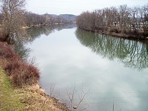
The Tuscarawas River in Dover in 2006
|
|

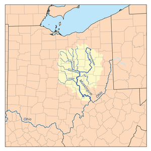
Map of the Muskingum River watershed showing the Tuscarawas
|
|
| Country | United States |
| State | Ohio |
| Counties | Stark, Summit, Tuscarawas, Coshocton |
| Physical characteristics | |
| Main source | near Hartville 40°56′34″N 81°20′45″W / 40.94278°N 81.34583°W |
| River mouth | Muskingum River Coshocton 735 ft (224 m) 40°16′31″N 81°52′24″W / 40.27528°N 81.87333°W |
| Length | 129.9 mi (209.1 km) |
| Discharge (location 2) |
|
| Basin features | |
| Basin size | 2,590 sq mi (6,700 km2) |
The Tuscarawas River is a major river in northeastern Ohio, United States. It is about 130 miles (209 km) long. This river is a main branch of the Muskingum River.
The Tuscarawas River is part of a huge water system. Its waters eventually flow into the Ohio River, then the Mississippi River. Finally, they reach the Gulf of Mexico. The river drains an area of about 2,590 square miles (6,700 km²). This area includes parts of the Allegheny Plateau.
Contents
River's Journey: Where the Tuscarawas Flows
The Tuscarawas River starts southwest of Hartville. This is in northern Stark County. It first flows west through Uniontown. Then it enters southern Summit County.
- The river passes through the Portage Lakes area. This is south of Akron and Barberton.
- From Barberton, the Tuscarawas generally flows south. It goes through Stark and Tuscarawas counties.
- Many towns grew along its banks. These include Clinton, Canal Fulton, and Massillon. Other towns are Navarre, Bolivar, and Zoar. Also, Dover and New Philadelphia.
- South of New Philadelphia, the river turns southwest and west. It flows past Tuscarawas and Gnadenhutten. It also passes Port Washington and Newcomerstown. These were once villages of the Lenape people.
- The river then enters Coshocton County. In the city of Coshocton, it joins the Walhonding River. Together, they form the Muskingum River.

The Ohio and Erie Canal
The Ohio and Erie Canal was built next to the river. This happened between 1828 and 1830. The canal helped move goods and people. It made transportation much easier.
However, the canal's use started to decline in the 1850s. A big flood in 1913 damaged it badly. It could not be repaired after that. Today, parts of the canal's old towpath are used as a trail. People enjoy hiking and bicycling on it.
Other Names for the River
The Tuscarawas River has had other names in the past. These names came from Native American terms. Some historical names include:
- Little Muskingum River
- Mashongam River
- Tuscarawa River
- Tuskarawas Creek
Fish Safety
As of 2006, the state of Ohio has given advice about eating fish from the river. It is recommended to limit how much fish you eat. This is because some fish have small amounts of certain chemicals. These chemicals are mercury and PCBs.
Tributaries: Rivers Joining the Tuscarawas
Many smaller rivers and creeks flow into the Tuscarawas River. These are called tributaries.
- In Summit County, Chippewa Creek joins near Clinton.
- Sandy Creek flows in near Bolivar in Stark County.
- In Tuscarawas County, Conotton Creek joins southeast of Zoar.
- Sugar Creek meets the river at Dover.
- Stillwater Creek flows in north of Tuscarawas.
- Nimishillen Creek is a tributary of Sandy Creek. It drains the city of Canton.
River Flow: How Much Water Moves
Scientists measure how much water flows in rivers. This is called the flow rate.
- Near Newcomerstown, the river's average flow was 2,591 cubic feet per second (73 cubic meters per second) between 1922 and 2005.
- The highest flow ever recorded there was 46,800 cubic feet per second (1,325 cubic meters per second) on January 26, 1937.
- The lowest flow was 216 cubic feet per second (6 cubic meters per second) on August 15, 1944.
- Further upstream, near Massillon, the average flow was 466 cubic feet per second (13 cubic meters per second) between 1938 and 2005.
- The highest flow recorded there was 10,700 cubic feet per second (303 cubic meters per second) on July 5, 1969.
- The lowest flow was 45 cubic feet per second (1.3 cubic meters per second) on September 20, 1999.
In Popular Culture
The Tuscarawas River has appeared in books and songs.
- In Conrad Richter's novel The Light in the Forest (1953), a character remembers a scene along the Tuscarawas River.
- The band Sun Kil Moon mentions the Tuscarawas in their song "Carry Me, Ohio". The lyric says, "Tuscarawas flows into the prairie land." This refers to how the river's water eventually reaches the Mississippi River.
 | Chris Smalls |
 | Fred Hampton |
 | Ralph Abernathy |

