Conotton Creek facts for kids
Quick facts for kids Conotton Creek |
|
|---|---|

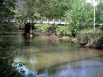
Connoton Creek flows under Ohio State Route 39 in Sherrodsville, Ohio
|
|
| Other name(s) | One Leg Creek |
| Country | United States |
| State | Ohio |
| Physical characteristics | |
| Main source | Green Township, Harrison County 1,240 ft (380 m) 40°19′42″N 80°57′08″W / 40.32833°N 80.95222°W |
| River mouth | Tuscarawas River Fairfield Township, Tuscarawas County 874 ft (266 m) 40°34′34″N 81°23′32″W / 40.57611°N 81.39222°W |
| Length | 38.7 mi (62.3 km) |
| Basin features | |
| Basin size | 286 sq mi (740 km2) |
Conotton Creek is a cool stream in eastern Ohio, United States. It flows for about 38.7 miles (62.3 km). This creek is an important part of the bigger Mississippi River system. It helps drain water from a large area of 286 square miles (741 km²). This area covers parts of Carroll, Harrison, and Tuscarawas County, Ohio.
The creek starts high up at 1240 feet (378 meters). It then flows down to 874 feet (266 meters) where it joins the Tuscarawas River.
Contents
Conotton Creek: A Journey Through Ohio
Conotton Creek begins its journey in eastern Harrison County, Ohio. It flows generally west-northwest. Along its path, the creek passes through several towns. These include Jewett, Scio, Conotton, Bowerston, Leesville, Sherrodsville, New Cumberland, and Somerdale. Finally, it reaches its mouth in central Tuscarawas County.
A railway, the Wheeling and Lake Erie Railway, runs along the creek's valley. Also, two state routes follow the creek. Ohio State Route 151 is near the source to Bowerston. Ohio State Route 212 runs from Bowerston to the creek's end. There's even a fun path called the Conotton Creek Trail that goes from Bowerston to Jewett.
What's in a Name?
Conotton Creek has had a few different names over time. The Geographic Names Information System lists some of these.
- Connotten Creek
- Connotton Creek
- Conolton Creek
- Conoten Creek
- Gutgatsink Creek
- Kannotten Creek
- Kennottenhead Creek
- Knottenhead Creek
- One Leg Creek
In the 1800s, people sometimes called it "One Leg Creek." This name came from a Native American person who lived near where the creek meets the Tuscarawas River.
In 1808, the Ohio government said the stream was "navigable." This meant boats could travel on it. But this rule was changed in 1816. This was probably so people could build dams for mills along the creek.
Important Lakes and Dams
Conotton Creek and its smaller streams are part of a system that helps control floods.
Dover Dam
The Dover Dam is located downstream on the Tuscarawas River. It's usually dry, but it can hold back water from Conotton Creek and its tributaries. This creates a temporary lake up to 916 feet (279 meters) high. This is done by the United States Army Corps of Engineers to help prevent floods further downstream.
Atwood Lake
Atwood Lake is a beautiful lake formed by the Atwood Dam. This dam is near the mouth of a tributary called Indian Fork. Atwood Lake usually has a water level of 928 feet (283 meters). It can go up to a maximum of 941 feet (287 meters) during heavy rains.
Leesville Lake
Another important lake is Leesville Lake. It is formed by the Leesville Dam on McGuire Creek, which is another tributary of Conotton Creek. Leesville Lake's normal water level is 963 feet (294 meters). It can reach a maximum of 977.5 feet (298 meters).
 | Kyle Baker |
 | Joseph Yoakum |
 | Laura Wheeler Waring |
 | Henry Ossawa Tanner |

