Carroll County, Ohio facts for kids
Quick facts for kids
Carroll County
|
|||
|---|---|---|---|

|
|||
|
|||

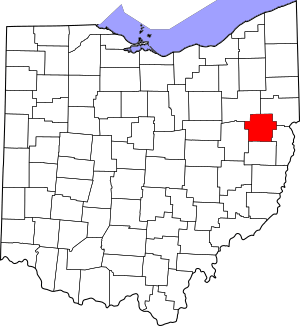
Location within the U.S. state of Ohio
|
|||
 Ohio's location within the U.S. |
|||
| Country | |||
| State | |||
| Founded | January 1, 1833 | ||
| Named for | Charles Carroll of Carrollton | ||
| Seat | Carrollton | ||
| Largest village | Carrollton* | ||
| Area | |||
| • Total | 399 sq mi (1,030 km2) | ||
| • Land | 395 sq mi (1,020 km2) | ||
| • Water | 4.3 sq mi (11 km2) 1.1%% | ||
| Population
(2020)
|
|||
| • Total | 26,721 |
||
| • Density | 67/sq mi (26/km2) | ||
| Time zone | UTC−5 (Eastern) | ||
| • Summer (DST) | UTC−4 (EDT) | ||
| Congressional district | 6th | ||
|
|||
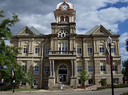
Carroll County is a county located in the state of Ohio, in the United States. It's a place where about 26,721 people lived in 2020. The main town, or county seat, is Carrollton. However, the largest village in the county is Minerva.
The county is named after Charles Carroll of Carrollton. He was the very last person to sign the Declaration of Independence who was still alive. Carroll County is also part of a larger area called the Canton-Massillon, OH Metropolitan Statistical Area. It's also in the Appalachian Ohio region, which is known for its beautiful hills.
Contents
History of Carroll County
Carroll County was officially created on December 25, 1832. It was formed using parts of several nearby counties. These included Columbiana, Harrison, Jefferson, Stark, and Tuscarawas counties.
A very old path, known as the Great Trail, runs through Carroll County. This trail was important long ago. It connected the forks of the Ohio River with Lake Erie and the flat lands further inland.
Geography and Location
Carroll County covers a total area of about 399 square miles. Most of this is land, about 395 square miles. The rest, about 4.3 square miles, is water. This makes it one of the smaller counties in Ohio. In fact, it's the fifth smallest in land area and the smallest overall.
Counties Nearby
Carroll County shares its borders with several other counties:
- Columbiana County (to the northeast)
- Jefferson County (to the southeast)
- Harrison County (to the south)
- Tuscarawas County (to the southwest)
- Stark County (to the northwest)
Main Roads
Many state highways pass through Carroll County. These roads help people travel around the area. Some of the main ones include:
 SR 9
SR 9 SR 39
SR 39 SR 43
SR 43 SR 164
 SR 171
 SR 183
 SR 212
 SR 332
 SR 524
 SR 542
People of Carroll County (Demographics)
The number of people living in Carroll County has changed over the years.
| Historical population | |||
|---|---|---|---|
| Census | Pop. | %± | |
| 1840 | 18,108 | — | |
| 1850 | 17,685 | −2.3% | |
| 1860 | 15,738 | −11.0% | |
| 1870 | 14,491 | −7.9% | |
| 1880 | 16,416 | 13.3% | |
| 1890 | 17,566 | 7.0% | |
| 1900 | 16,811 | −4.3% | |
| 1910 | 15,761 | −6.2% | |
| 1920 | 15,942 | 1.1% | |
| 1930 | 16,057 | 0.7% | |
| 1940 | 17,449 | 8.7% | |
| 1950 | 19,039 | 9.1% | |
| 1960 | 20,857 | 9.5% | |
| 1970 | 21,579 | 3.5% | |
| 1980 | 25,598 | 18.6% | |
| 1990 | 26,521 | 3.6% | |
| 2000 | 28,836 | 8.7% | |
| 2010 | 28,836 | 0.0% | |
| 2020 | 26,721 | −7.3% | |
| U.S. Decennial Census 1790-1960 1900-1990 1990-2000 2020 |
|||
What the 2010 Census Showed
In 2010, there were 28,836 people living in Carroll County. There were 11,385 households, which are groups of people living together. The population density was about 73 people per square mile.
Most people in the county were white (97.8%). A smaller number were Black or African American (0.5%), American Indian (0.3%), or Asian (0.2%). About 0.8% of the population was of Hispanic or Latino background.
Many families in Carroll County have German roots (29.2%). Other common backgrounds include Irish (14.4%), American (11.3%), English (9.8%), and Italian (6.1%).
About 29.8% of households had children under 18 living with them. The average household had 2.50 people. The average age of people in the county was 43.1 years old.
Culture and Festivals
Carroll County hosts some fun local events that celebrate its history and community.
The Great Trail Festival
This festival takes place near the village of Malvern every year. It usually happens at the end of August and beginning of September. The festival celebrates old-fashioned music, arts, and crafts. It focuses on Ohio's early history, especially the Native American and French heritage of the region. You might even see a small group of buffalo and a battle reenactment!
Algonquin Mill Fest
Another popular local event is the Algonquin Mill Fest. It's held about 4 miles south of Carrollton. This festival takes place at the Algonquin Mill, which is a pioneer village. The village has an old one-room schoolhouse, a saw mill and flour mill powered by steam, and other historic buildings. Visitors can buy handmade arts and crafts. They can also enjoy pancakes and chicken barbecue dinners.
Flight Fest
In Malvern, there's also Flight Fest. This is a competition where people fly remote-control airplanes. It's a great event for anyone interested in aviation!
Education
Carroll County has several public school districts and high schools.
Public School Districts
- Brown Local School District
- Carrollton Exempted Village School District
- Conotton Valley Union Local School District
High Schools
- Carrollton High School
- Conotton Valley High School
- Malvern High School
Communities in Carroll County
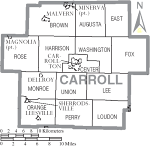
Carroll County is made up of several different types of communities.
Villages
These are smaller towns in the county:
- Carrollton (This is the county seat, where the main government offices are)
- Dellroy
- Leesville
- Magnolia
- Malvern
- Minerva
- Sherrodsville
Townships
Townships are areas of land that often include smaller communities or rural areas.
- Augusta
- Brown
- Center
- East
- Fox
- Harrison
- Lee
- Loudon
- Monroe
- Orange
- Perry
- Rose
- Union
- Washington
Census-Designated Places
These are areas that are like towns but are not officially incorporated as villages or cities.
- Lake Mohawk
- Pekin
Unincorporated Communities
These are small places that don't have their own local government.
See also
 In Spanish: Condado de Carroll (Ohio) para niños
 | Kyle Baker |
 | Joseph Yoakum |
 | Laura Wheeler Waring |
 | Henry Ossawa Tanner |


