Columbiana County, Ohio facts for kids
Quick facts for kids
Columbiana County
|
|||
|---|---|---|---|

|
|||
|
|||

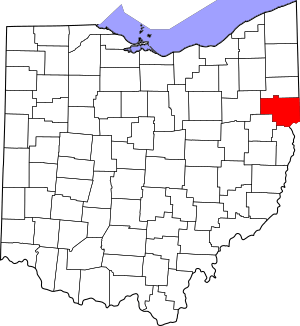
Location within the U.S. state of Ohio
|
|||
 Ohio's location within the U.S. |
|||
| Country | |||
| State | |||
| Founded | May 1, 1803 | ||
| Named for | Christopher Columbus | ||
| Seat | Lisbon | ||
| Largest city | Salem | ||
| Area | |||
| • Total | 535 sq mi (1,390 km2) | ||
| • Land | 532 sq mi (1,380 km2) | ||
| • Water | 2.8 sq mi (7 km2) 0.5%% | ||
| Population
(2020)
|
|||
| • Total | 101,877 |
||
| • Density | 190/sq mi (70/km2) | ||
| Time zone | UTC−5 (Eastern) | ||
| • Summer (DST) | UTC−4 (EDT) | ||
| Congressional district | 6th | ||
Columbiana County is a county in the U.S. state of Ohio. In 2020, about 101,877 people lived here. The main town, called the county seat, is Lisbon. The biggest city is Salem.
The county was created in 1803. Its name comes from Christopher Columbus, a famous explorer from the 1400s. Columbiana County is part of a larger area called the Mahoning Valley. It is also considered part of Appalachian Ohio. This means it shares some culture with the Appalachian Mountains region.
Northern parts of the county are more like Northeast Ohio. But southern parts are more like Greater Pittsburgh and the Upper Ohio Valley. The county is mostly rural, meaning it has a lot of countryside. It sits between these two bigger city areas.
Contents
History of Columbiana County
Early Native American Life
Long ago, the Native American peoples who lived here were the Lenape, Mingo, and Wyandot. The Wyandot people had a camp where the city of Salem is today. Important trails used by these groups ran through the county. The most famous was the Great Trail. It went through the southern parts of the county towards Sandusky.
In the mid-1700s, American colonists started exploring the area. George Washington, who later became president, even camped near what is now East Liverpool in 1770.
First Settlements and County Founding
In the 1780s, Native Americans gave up control of the land. Then, the area was surveyed. This means it was carefully measured and mapped out. This mapping system was very important. It was one of the first of its kind in any modern country.
The first permanent settlement was in 1792 or 1793. A hunter named John Quinn settled near Calcutta. Columbiana County was officially founded in 1803. Its name combines "Columbus" with "-iana," meaning "land of."
Early settlers included Quakers and Scotch-Irish people from Pennsylvania. Later, many Germans also moved to the county.
The Civil War and Industries
During the American Civil War, a battle happened here. On July 26, 1863, Confederate soldiers led by John Morgan were captured. This happened at the Battle of Salineville. It was one of the northernmost battles of the war.
Columbiana County was once famous for its pottery industry. The city of East Liverpool and nearby towns made more than half of all the ceramics in the United States. Over 300 pottery factories once operated in East Liverpool. Other big industries included making iron and bricks. Transportation was also key, with the Ohio River, the Sandy and Beaver Canal, and the Pennsylvania Railroad system.
Recent Events: Train Derailment
On February 3, 2023, a freight train carrying chemicals derailed in East Palestine. After the fire burned for two days, emergency teams decided to do a controlled burn of some chemicals. This released certain chemicals into the air and affected the Ohio River.
Geography of Columbiana County
The county covers about 535 square miles. Most of this is land, with a small part being water.
Neighboring Counties
Columbiana County shares borders with these other counties:
- Mahoning County (north)
- Lawrence County, Pennsylvania (northeast)
- Beaver County, Pennsylvania (east)
- Hancock County, West Virginia (southeast)
- Jefferson County (south)
- Carroll County (southwest)
- Stark County (west)
Main Roads
Many important roads run through Columbiana County. These include:
 US 30
US 30 US 62
US 62 SR 7
SR 7 SR 9
SR 9 SR 11
SR 11 SR 14
SR 14 SR 39
SR 39 SR 45
SR 45 SR 46
SR 46 SR 154
 SR 164
 SR 170
 SR 172
 SR 173
 SR 267
 SR 344
 SR 517
 SR 518
 SR 558
 SR 644
People of Columbiana County
| Historical population | |||
|---|---|---|---|
| Census | Pop. | %± | |
| 1810 | 10,878 | — | |
| 1820 | 22,033 | 102.5% | |
| 1830 | 35,592 | 61.5% | |
| 1840 | 40,378 | 13.4% | |
| 1850 | 33,621 | −16.7% | |
| 1860 | 32,836 | −2.3% | |
| 1870 | 38,299 | 16.6% | |
| 1880 | 48,602 | 26.9% | |
| 1890 | 59,029 | 21.5% | |
| 1900 | 68,590 | 16.2% | |
| 1910 | 76,619 | 11.7% | |
| 1920 | 83,131 | 8.5% | |
| 1930 | 86,484 | 4.0% | |
| 1940 | 90,121 | 4.2% | |
| 1950 | 98,920 | 9.8% | |
| 1960 | 107,004 | 8.2% | |
| 1970 | 108,310 | 1.2% | |
| 1980 | 113,572 | 4.9% | |
| 1990 | 108,276 | −4.7% | |
| 2000 | 112,075 | 3.5% | |
| 2010 | 107,841 | −3.8% | |
| 2020 | 101,877 | −5.5% | |
| U.S. Decennial Census 1790–1960 1900–1990 1990–2000 2020 |
|||
In 2010, there were 107,841 people living in Columbiana County. Most people (95.5%) were white. About 2.2% were Black or African American. People of Hispanic or Latino origin made up 1.2% of the population.
Many families lived in the county. The average age was about 42 years old. The median income for a family was around $48,948 per year. About 16% of the population lived below the poverty line.
Education in Columbiana County
Colleges and Universities
Students can attend several colleges in the county:
- Allegheny Wesleyan College
- Kent State University at East Liverpool
- Kent State University at Salem
Career and Technical Schools
There are also schools for specific job training:
- Columbiana County Career and Technical Center
- East Ohio College
- New Castle School of Trades
Public School Districts
Many public school districts serve the county's students:
- Alliance City School District
- Beaver Local School District
- Columbiana Exempted Village School District
- Crestview Local School District
- East Liverpool City School District
- East Palestine City School District
- Leetonia Exempted Village School District
- Lisbon Exempted Village School District
- Minerva Local School District
- Salem City School District
- Southern Local School District
- United Local School District
- Wellsville Local School District
- West Branch Local School District
High Schools
Here are some of the high schools in Columbiana County:
- Beaver Local High School
- Columbiana High School
- Crestview High School
- David Anderson Junior/Senior High School
- East Liverpool Junior/Senior High School
- East Palestine High School
- Leetonia High School
- Salem High School
- Southern Local Junior/Senior High School
- United High School
- Wellsville Junior/Senior High School
Private Schools
There are also private schools in the area:
- Heartland Christian School – Columbiana
- East Liverpool Christian School – Glenmoor
- St. Paul Elementary School – Salem
Communities in Columbiana County
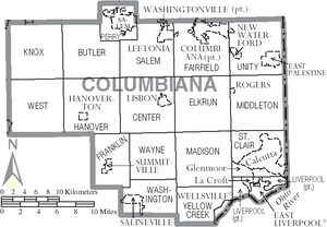
Columbiana County has several cities, villages, and other communities.
Cities
Villages
Townships
- Butler
- Center
- Elkrun
- Fairfield
- Franklin
- Hanover
- Knox
- Liverpool
- Madison
- Middleton
- Perry
- Salem
- St. Clair
- Unity
- Washington
- Wayne
- West
- Yellow Creek
Census-Designated Places (CDPs)
CDPs are areas that are like towns but are not officially incorporated as cities or villages.
- Calcutta
- Damascus
- East Rochester
- Glenmoor
- Homeworth
- La Croft
- Lake Tomahawk
- Negley
- Salem Heights
Unincorporated Communities
These are smaller communities that are not officially part of a city or village.
- Achor
- Bayard
- Cannons Mill
- Chambersburg
- Clarkson
- Dungannon
- East Carmel
- East Fairfield
- Elkton
- Franklin Square
- Fredericktown
- Gavers
- Glasgow
- Guilford
- Highlandtown
- Kensington
- Lynchburg
- Middleton
- Mill Rock
- Millport
- Moultrie
- New Alexander
- New Garden
- New Middleton
- New Salisbury
- North Georgetown
- Reading
- Signal
- Teegarden
- Unionville
- Unity
- Valley
- West Point
- Williamsport
- Winona
Community Populations (2020 Census)
This table shows the population of the main communities in Columbiana County based on the 2020 census. * Most of the town is in Columbiana County
** A smaller part of the town is in Columbiana County
† County seat
| Rank | City/Town/etc. | Population (2020 Census) | Township | Type of Community |
|---|---|---|---|---|
| 1 | Salem* | 11,915 | Perry, Salem | City |
| 2 | East Liverpool | 9,958 | Liverpool | City |
| 3 | Columbiana* | 6,559 | Fairfield, Unity | City |
| 4 | East Palestine | 4,761 | Unity | Village |
| 5 | Calcutta | 3,941 | St. Clair | CDP |
| 6 | Minerva** | 3,684 | West | Village |
| 7 | Wellsville | 3,113 | Yellow Creek | Village |
| 8 | † Lisbon | 2,597 | Center, Elkrun | Village |
| 9 | Leetonia | 1,833 | Salem, Fairfield | Village |
| 10 | Glenmoor | 1,829 | St. Clair | CDP |
| 11 | Salineville | 1,206 | Washington | Village |
| 12 | New Waterford | 1,194 | Unity | Village |
| 13 | La Croft | 1,078 | Liverpool | CDP |
| 14 | Washingtonville* | 712 | Salem | Village |
| 15 | Lake Tomahawk | 494 | Middleton | CDP |
| 16 | Homeworth | 492 | Knox | CDP |
| 17 | Damascus** | 418 | Butler | CDP |
| 18 | Hanoverton | 354 | Hanover | Village |
| 19 | Negley | 274 | Middleton | CDP |
| 20 | East Rochester | 224 | West | CDP |
| 21 | Rogers | 194 | Middleton | Village |
| 22 | Summitville | 110 | Franklin | Village |
Famous People from Columbiana County
Many notable people have connections to Columbiana County:
- Harvey Firestone: He started the Firestone Tire and Rubber Company.
- Mark Hanna: A U.S. senator from Ohio who grew up in Lisbon.
- Lou Holtz: A well-known college football coach who grew up in East Liverpool.
- Rich Karlis: A former NFL placekicker for the Denver Broncos and other teams, from Salem, Ohio.
- William McKinley: The 25th president of the United States. He grew up in Lisbon.
- William Ralston: He founded the Bank of California and was once a very rich man. He was born in Columbiana County.
- Derek Wolfe: A former NFL defensive end for the Denver Broncos and Baltimore Ravens. He grew up in Negley.
See also
 In Spanish: Condado de Columbiana para niños
 | Georgia Louise Harris Brown |
 | Julian Abele |
 | Norma Merrick Sklarek |
 | William Sidney Pittman |


