East Rochester, Ohio facts for kids
Quick facts for kids
East Rochester, Ohio
|
|
|---|---|

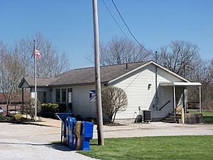
East Rochester Post Office
|
|

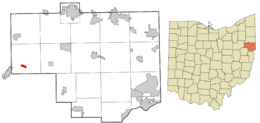
Location of East Rochester in Columbiana County, Ohio.
|
|
| Country | United States |
| State | Ohio |
| County | Columbiana |
| Township | West |
| Area | |
| • Total | 0.43 sq mi (1.10 km2) |
| • Land | 0.43 sq mi (1.10 km2) |
| • Water | 0.00 sq mi (0.00 km2) |
| Elevation | 1,079 ft (329 m) |
| Population
(2020)
|
|
| • Total | 224 |
| • Density | 525.82/sq mi (202.93/km2) |
| Time zone | UTC-5 (Eastern (EST)) |
| • Summer (DST) | UTC-4 (EDT) |
| ZIP code |
44625
|
| Area code(s) | 330, 234 |
| FIPS code | 39-24024 |
| GNIS feature ID | 2628889 |
| School District | Minerva Local School District |
East Rochester is a small community in Ohio, United States. It is located in Columbiana County, within West Township. It is considered an unincorporated community, meaning it does not have its own local government like a city or town.
East Rochester is also a census-designated place (CDP). This means the U.S. Census Bureau defines it for statistical purposes. In 2020, about 224 people lived there. The community is found along U.S. Route 30, a major road. It has its own post office with the ZIP code 44625.
History of East Rochester
| Historical population | |||
|---|---|---|---|
| Census | Pop. | %± | |
| 2010 | 231 | — | |
| 2020 | 224 | −3.0% | |
| U.S. Decennial Census | |||
East Rochester was first officially known as "Rochester." It was planned out and officially recorded, a process called "platting," in 1834. This means its streets and lots were laid out on a map.
A railroad, the Cleveland and Pittsburgh Railroad, was built through the community in 1852. This helped connect East Rochester to other places. When a post office was set up, the name "East Rochester" was chosen. This was done to avoid confusion with another place in Ohio already named Rochester. The post office has been serving the community since 1840.
Geography and Location
East Rochester is situated along U.S. Route 30. This road connects it to nearby cities. It is about 32 miles (51 km) northwest of East Liverpool. It is also about 22 miles (35 km) east of Canton.
The closest town with its own government is Minerva. Minerva is located about 4 miles (6 km) to the west. East Rochester covers an area of about 0.43 square miles (1.1 square kilometers). It is located in the valley of Sandy Creek. This creek flows west towards the Tuscarawas River, which is a branch of the Ohio River.
Education for Students
Children living in East Rochester attend schools within the Minerva Local School District. This school district provides education for students from kindergarten through high school.
The schools that serve the community are:
- Minerva Elementary School – for students in grades K-5
- Minerva Middle School – for students in grades 6-8
- Minerva High School – for students in grades 9-12
See also
 In Spanish: East Rochester (Ohio) para niños
 | May Edward Chinn |
 | Rebecca Cole |
 | Alexa Canady |
 | Dorothy Lavinia Brown |

