Negley, Ohio facts for kids
Quick facts for kids
Negley, Ohio
|
|
|---|---|

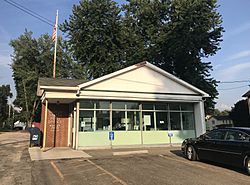
Negley post office
|
|

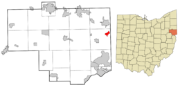
Location of Negley in Columbiana County, Ohio.
|
|
| Country | United States |
| State | Ohio |
| County | Columbiana |
| Township | Middleton |
| Area | |
| • Total | 0.90 sq mi (2.32 km2) |
| • Land | 0.90 sq mi (2.32 km2) |
| • Water | 0.00 sq mi (0.00 km2) |
| Elevation | 856 ft (261 m) |
| Population
(2020)
|
|
| • Total | 274 |
| • Density | 305.80/sq mi (118.01/km2) |
| Time zone | UTC-5 (Eastern (EST)) |
| • Summer (DST) | UTC-4 (EDT) |
| ZIP code |
44441
|
| Area code(s) | 330, 234 |
| FIPS code | 39-53802 |
| GNIS feature ID | 2628937 |
| School District | East Palestine City School District |
Negley is a small community in Ohio, United States. It's not an official city or town, but a "census-designated place" (CDP). This means it's an area that the government counts for population statistics. Negley is located in Middleton Township, Columbiana County, Ohio. In 2020, about 274 people lived there.
Contents
Discovering Negley's Past
Negley got its name from James S. Negley. He was a very important person during the American Civil War, serving as a Major General for the Union. After the war, he became a politician, working in the United States House of Representatives.
Later, James Negley went into the railroad business. He was the president of a railway company called the New York, Pittsburgh & Chicago Railway. In 1883, his company planned out Negley as the very first new town along its train line. They named it in his honor. A post office has been open in Negley since 1883.
Negley grew into a small community because of a nearby coal mine. The Powers Mining Company operated this mine. The community once had a special display honoring local people who served in World War II. This display was taken down in the 1960s because it had become old and worn out.
Where is Negley Located?
Negley is in the eastern part of Middleton Township, Columbiana County, Ohio. It's very close to the border between Ohio and Pennsylvania. The community sits near two creeks, the North Fork of the Little Beaver Creek and Bull Creek. It's also located at the base of the Appalachian Mountains.
The area of Negley is about 0.89 square miles (2.32 square kilometers). All of this area is land, with no large bodies of water.
Local Businesses in Negley
One of the businesses in Negley is PennOhio Waste. This company operates a special landfill where they dispose of construction and demolition waste.
Learning in Negley: Schools
Children who live in Negley attend schools in the East Palestine City School District. Negley used to have its own traditional schoolhouse a long time ago. Later, it had an elementary school.
Today, students from Negley go to these schools:
- East Palestine Elementary School – for students in grades K-4
- East Palestine Middle School – for students in grades 5-8
- East Palestine High School – for students in grades 9-12
Getting Around: Transportation
Two main highways pass through Negley, making it easy to travel to and from the community:
A short train line, the Youngstown and Southeastern Railroad, also runs through Negley. Negley was once home to the only repair shop for the Youngstown and Southern Railway.
Famous People from Negley
Some interesting people have come from Negley:
- Ammon Hennacy – He was a writer and activist known for his Christian anarchist beliefs.
- Kyle Maite – He is a musician, known as the rhythm and lead guitarist for the band Hit the Lights.
- Derek Wolfe – He was a professional American football player. He played as a defensive end for the Denver Broncos and the Baltimore Ravens in the NFL.
See also
 In Spanish: Negley (Ohio) para niños
 | Janet Taylor Pickett |
 | Synthia Saint James |
 | Howardena Pindell |
 | Faith Ringgold |

