Northeast Ohio facts for kids
Quick facts for kids
Northeast Ohio
|
|
|---|---|
|
Images top to bottom, left to right: the skylines of Cleveland, Akron, Canton, Youngstown, and a view of downtown Cleveland from Parma
|
|
| Country | |
| State | |
| Largest city | Cleveland |
| Other cities |
List
|
| Area | |
| • Land | 22,067.4 km2 (8,520.29 sq mi) |
| • Water | 8,040 km2 (3,104.2 sq mi) |
| Population
(2020)
|
|
| • Total | 4,502,460 |
| • Density | 196.48/km2 (508.89/sq mi) |
| Time zone | UTC-5 (EST) |
| • Summer (DST) | UTC-4 (EDT) |
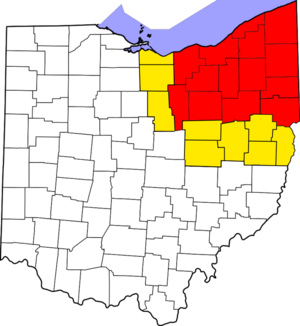
Northeast Ohio is a special part of the state of Ohio in the United States. It's a region with its own unique geography and culture. This area stretches from the southern shore of Lake Erie down to the start of the Appalachian Mountains.
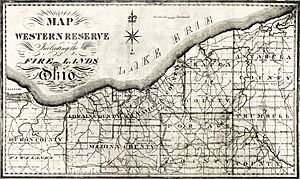
More than 4.5 million people call Northeast Ohio home. The biggest city here is Cleveland, which had over 372,000 residents in 2020. Other important cities include Akron, Canton, Mansfield, Sandusky, and Youngstown. A big part of Northeast Ohio used to be known as the Connecticut Western Reserve a long time ago.
Contents
What Makes Up Northeast Ohio?
The exact borders of Northeast Ohio can change depending on who you ask. But generally, it includes 16 to 23 counties. This region is home to many cities and towns.
It has six main city areas, called metropolitan statistical areas. These are like big city zones. There are also eight smaller city areas, called micropolitan statistical areas. Together, these areas make up a large and busy part of Ohio.
Counties in Northeast Ohio
Northeast Ohio is made up of many different counties. Here is a list of the counties that are usually included in this region:
Cleveland–Akron–Canton Combined Statistical Area
Most of Northeast Ohio is part of a very large area called the Cleveland–Akron–Canton Combined Statistical Area (CSA). Think of a CSA as a group of nearby cities and their surrounding areas that are all connected by jobs and people moving between them.
In 2020, this CSA was the 17th largest in the United States, with over 3.7 million people. It includes major cities like Cleveland, Akron, and Canton. It also includes smaller areas like Sandusky, Norwalk, and Wooster.
This large area is also part of the Great Lakes Megalopolis. A megalopolis is a huge chain of cities and towns that are very close together.
Higher Education in Northeast Ohio
Northeast Ohio is home to many colleges and universities. These schools offer different types of education, from large universities to smaller colleges. Students can study a wide range of subjects here.
Some of the well-known institutions include:
- Ashland University (Ashland)
- Baldwin Wallace University (Berea)
- Case Western Reserve University (Cleveland)
- Cleveland State University (Cleveland)
- Kent State University (Kent)
- Lorain County Community College (Elyria)
- Malone University (Canton)
- Northeast Ohio Medical University (Rootstown)
- Oberlin College (Oberlin)
- University of Akron (Akron)
- Youngstown State University (Youngstown)
Sports and Recreation
Northeast Ohio is a great place for sports fans! It has several professional sports teams that play in major leagues.
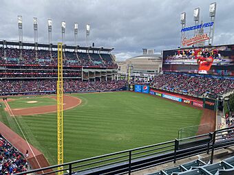
The Cleveland Guardians play Major League Baseball at Progressive Field. The Cleveland Browns play NFL football at Cleveland Browns Stadium. And the Cleveland Cavaliers play NBA basketball at Rocket Mortgage FieldHouse. This arena is also home to the Cleveland Monsters, a professional hockey team.
There are also many other professional and college sports teams in the region. For example, the Akron RubberDucks are a minor league baseball team. You can also find teams for soccer, ice hockey, and more.
If you like racing, you can visit Mid-Ohio Sports Car Course or Summit Motorsports Park.
Many colleges in the area also have strong sports programs. They compete in different divisions of the NCAA.
For outdoor fun, the Cleveland Metroparks offer beautiful nature preserves around Cleveland. The Cuyahoga Valley National Park is another amazing place to explore. It covers the Cuyahoga River valley between Cleveland and Akron. You can also visit Mentor Headlands Beach, which is the longest natural beach on the Great Lakes.
Transportation
Getting around Northeast Ohio is easy with many different transportation options.
Local Transit
Many counties and cities have their own public transportation systems. These systems help people travel by bus or other means within the local area.
- Ashtabula County Transportation System
- Geauga County Transit
- Greater Cleveland Regional Transit Authority
- Laketran
- Lorain County Transit
- Medina County Transit
- METRO Regional Transit Authority
- Portage Area Regional Transportation Authority
- Richland County Transit
- Stark Area Regional Transit Authority
- Steel Valley Regional Transit Authority
- Western Reserve Transit Authority
Amtrak Stations
You can also travel by train through Northeast Ohio. Amtrak has stations in several cities:
- Alliance station
- Cleveland Lakefront Station
- Elyria station
- Sandusky station
Highways
Major highways crisscross Northeast Ohio, making it easy to drive between cities.
Interstate Highways
These are major highways that connect states.
 Interstate 71
 Interstate 271
 Interstate 76
 Interstate 77
 Interstate 80
 Interstate 480
 Interstate 90
 Interstate 490
 Interstate 277
 Interstate 680
US Highways
These are also important national highways.
 U.S. Route 6
 U.S. Route 20
 U.S. Route 30
 U.S. Route 42
 U.S. Route 62
 U.S. Route 224
 U.S. Route 250
 U.S. Route 322
 U.S. Route 422
Airports
Northeast Ohio has several airports for both commercial flights and smaller private planes.
- Cleveland-Hopkins International Airport (CLE) in Cleveland is the largest airport. It handles many commercial flights.
- Akron-Canton Regional Airport (CAK) serves the Akron and Canton areas. It also has commercial flights.
- Youngstown-Warren Regional Airport (YNG) serves the Youngstown and Warren areas.
Other airports in the region are mainly for smaller planes or private use. These include Cleveland Burke Lakefront Airport, Cuyahoga County Airport, and Lorain County Regional Airport.
Area Codes
Phone numbers in Northeast Ohio use different area codes. An area code is the first three numbers of a phone number. They help direct calls to the right part of the country.
In the 1950s, most of Northeast Ohio used area code 216. Over time, as more people got phones, new area codes were added.
- In 1996, area code 330 was created for the southern part of Northeast Ohio. This included cities like Akron and Canton.
- In 1997, area code 440 was added for areas around Cleveland but outside the city center. This helped provide more phone numbers.
- Sometimes, a city might even have parts in different area codes! For example, Parma was split between two area codes.
- To make sure there are enough phone numbers, new area codes can be "overlaid" on top of existing ones. This means new phone numbers in that area might get the new code. For example, area code 234 was added over 330. This means you sometimes need to dial all ten digits of a phone number, even for local calls.
- Soon, area code 436 will be added to overlap with 440, for the same reason.
 | William M. Jackson |
 | Juan E. Gilbert |
 | Neil deGrasse Tyson |


