
Cuyahoga River facts for kids
Quick facts for kids Cuyahoga River |
|
|---|---|

The Cuyahoga River in Cleveland.
|
|

Map of the Cuyahoga River drainage basin
|
|
| Country | United States |
| State | Ohio |
| Counties | Cuyahoga, Summit, Portage, Geauga |
| Cities | Cleveland, Akron, Cuyahoga Falls, Kent |
| Physical characteristics | |
| Main source | 1,093 feet (333.1 m) 41°26′26″N 81°09′07″W / 41.44056°N 81.15194°WConfluence of East Branch Cuyahoga River and West Branch Cuyahoga River near Pond Road and Rapids Road, Burton, Geauga County, Ohio |
| River mouth | Lake Erie at Cleveland, Cuyahoga County, Ohio 571 feet (174.0 m) 41°30′13″N 81°42′44″W / 41.50361°N 81.71222°W |
| Length | 84.9 miles (136.6 km) |
| Basin features | |
| Basin size | 809 square miles (2,100 km2) |
The Cuyahoga River is a river in the United States, found in Northeast Ohio. It flows through the city of Cleveland and empties into Lake Erie.
For many years, especially in the 20th century, the river was very dirty due to pollution from factories. It became so polluted that it actually "caught fire" at least 13 times! The most famous fire happened on June 22, 1969. This event helped start the American environmental movement.
Since then, people have worked hard to clean up the river. The city of Cleveland and the Ohio Environmental Protection Agency (OEPA) have led these efforts. In 2019, a group called American Rivers named the Cuyahoga "River of the Year." This was to celebrate 50 years of the river getting much healthier.
Contents
What's in a Name?
The name Cuyahoga likely means "crooked river." This comes from an old Native American word. The river's winding shape does look a bit like a crooked path.
Some people also say the name comes from a word meaning "jawbone." This is because the river's bends might remind someone of an animal's jaw. However, the "crooked river" meaning is the most widely accepted idea.
The River's Journey
The Cuyahoga River starts its journey in Hambden, Ohio. It flows south, then turns sharply north near Akron and Cuyahoga Falls. It then flows through the beautiful Cuyahoga Valley National Park. Finally, it reaches Cleveland and flows into Lake Erie.
The river is about 84.9 miles (136.6 km) long. It drains water from a large area of land, about 813 square miles (2,110 km2).
The Cuyahoga River was formed a long time ago by giant sheets of ice, called glaciers. When the last glaciers melted about 10,000 to 12,000 years ago, the river's path changed. It used to flow south, but the melting ice made it flow north towards Lake Erie. As it flowed, it carved its way around the rocks and dirt left by the glaciers. This is why the river has its famous U-shape and many bends. These bends make the river much longer than if it flowed in a straight line.
A River's History
The Cuyahoga River was an important landmark in early American history. In 1795, it marked part of the border of the United States after a peace treaty.
In 1796, a surveyor named Moses Cleaveland arrived at the river's mouth. He decided to start a settlement there, which later became the city of Cleveland.
Cleaning Up the River
.jpg)
For many years in the 1900s, the Cuyahoga River was one of the most polluted rivers in the United States. The part of the river from Akron to Cleveland had almost no fish. It was filled with oily films, thick black oil, and trash. The water had very little oxygen, so animals could not live there.
The river caught fire at least 13 times. The biggest fire, in 1952, caused over $1 million in damage to boats and buildings.
Things started to change in the late 1960s. Cleveland's mayor, Carl Stokes, helped get people to approve money to clean up the rivers. On June 22, 1969, another river fire started when a spark hit an oil slick. Mayor Stokes brought reporters to the river to show them how bad the pollution was.
Even though the 1969 fire didn't cause much damage, it got the attention of Time magazine. They used a dramatic photo from the larger 1952 fire in an article about America's polluted waterways. This article helped make people across the country aware of the problem.

The 1969 Cuyahoga River fire became a symbol of water pollution. It helped lead to important new laws like the Clean Water Act. It also led to the creation of the federal Environmental Protection Agency (EPA) and the Ohio Environmental Protection Agency (OEPA). These agencies work to protect our environment.
Thanks to these efforts, the water quality in the Cuyahoga River has greatly improved. Parts of the river that once had no fish now have 44 different kinds of fish! The most common fish found today are hogsuckers and spotfin shiners, which are sensitive to water quality. This shows how much cleaner the river has become.
In March 2019, the OEPA announced that fish caught in the river are now safe to eat. This is a huge success story for the Cuyahoga River.
.jpg)
How the River Was Changed

The lower part of the Cuyahoga River, near Cleveland, has been changed a lot by people. Originally, the river met Lake Erie in a shallow marsh. In 1827, a new, man-made mouth was created. This allows large ships to travel easily between the river and the lake.
The United States Army Corps of Engineers regularly dredges (cleans out the bottom of) the river. They make the lower 5 miles (8.0 km) of the river 27 feet (8.2 m) deep. This allows large freighter ships to carry materials like asphalt, gravel, and steel to factories along the riverbanks. The Corps of Engineers has also straightened parts of the river and made turning areas wider for these ships.

Breaking Ice
Sometimes, the United States Coast Guard helps break up ice on Lake Erie and the lower Cuyahoga River. This helps ships continue to use the river during colder months.
Flooding
People have tried to control flooding along the Cuyahoga River. However, many buildings are built in low-lying areas near the river. Heavy rains or snow can still cause severe flooding in these places.
The upper part of the Cuyahoga River drops steeply in elevation, creating waterfalls and rapids. The lower part of the river is much flatter and moves slowly. This means it can take a while for floodwaters to drain away.
Dams on the River
Dams are structures built across a river to control its flow. Several dams have been built on the Cuyahoga River over the years.
One important dam was the Brecksville Dam at river mile 20. It stopped fish from moving freely up and down the river. This dam was removed in 2020, which is great for fish!

The largest dam is the Gorge Metropolitan Park Dam, also known as the FirstEnergy Dam. It is 57 feet (17 m) tall. This dam created a large, still pool of water where oxygen levels were low, which was bad for water quality.
This dam was built in 1912 to help generate power. The power plant it served was shut down in 1991. For a long time, there was debate about removing the dam. Removing it would be expensive and complicated. The area behind the dam might also contain polluted sediments from the past.
However, in 2019, officials announced a plan to remove the Gorge Metropolitan Park Dam by 2023. This project will cost about $65 to $70 million. It is a big step towards restoring the river to a more natural state.
Two other dams in Cuyahoga Falls, the Sheraton and LeFever Dams, were removed in 2013. This helped bring about 1 mile (1.6 km) of the river back to its natural flow. It also created new whitewater areas for recreation.
Two smaller dams in Kent and Munroe Falls also affected water quality. The Munroe Falls Dam was changed in 2005, revealing a natural waterfall. The dam was later removed, leaving a natural ledge. The Kent Dam was bypassed in 2004. These changes have helped the river meet water quality standards in those areas.
Other Names for the Cuyahoga River
Over time, the Cuyahoga River has been known by several different names, including:
- Cajahage River
- Cayagaga River
- Cayahoga River
- Cayhahoga River
- Cayohoga River
- Cujahaga River
- Cuyohaga River
- Gichawaga Creek
- Goyahague River
- Gwahago River
- River de Saguin
- Rivière Blanche
- Rivière à Seguin
- Saguin River
- Yashahia
- Cayahaga River
- Cayanhoga River
- Cayhoga River
- Coyahoga River
- Cuahoga River
- Guyahoga River
- Gwahoga River
- Kiahagoh River
- White River
Images for kids
-
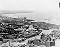
The river's mouth at Lake Erie in Cleveland, circa 1920.
See also
 In Spanish: Río Cuyahoga para niños
