Cuyahoga Valley National Park facts for kids
Quick facts for kids Cuyahoga Valley National Park |
|
|---|---|
|
IUCN Category II (National Park)
|
|
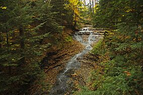
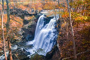
Waterfalls, such as this one, can be found throughout the park.
|
|
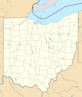
| Location | Summit County & Cuyahoga County, Ohio, United States |
| Nearest city | Cleveland, Akron |
| Area | 32,783 acres (51.2 sq mi; 132.7 km2) |
| Established | October 11, 2000 |
| Visitors | 2,860,059 (in 2023) |
| Governing body | National Park Service |
The Cuyahoga Valley National Park is a special place in Ohio, United States. It's a national park that helps protect and restore the beautiful natural areas along the Cuyahoga River. This park is located between the cities of Akron and Cleveland.
This park is about 32,783 acres (51.2 sq mi; 132.7 km2) big. It's managed by the National Park Service, but some parts are also looked after by local parks or private businesses. Cuyahoga Valley was first created as a "national recreation area" in 1974. Then, in 2000, it became a full national park. It's the only national park that started out as a recreation area.
Cuyahoga Valley is Ohio's only national park. It's also one of three national parks in the Great Lakes Basin. The other two are Isle Royale National Park and Indiana Dunes National Park. What makes Cuyahoga Valley unique is that it's right next to two big cities. It also has many roads, a railroad, small towns, and other attractions inside its borders. In 2023, almost 2.9 million people visited the park. This makes it one of the most visited national parks in the country.
Contents
Exploring the Park's Past
Early People of the Valley
Long ago, around 200 AD, people from the Hopewell Culture lived in this area. They built a special mound called the Everett Mound inside what is now the park.
Many different Native American tribes lived in or traveled through the Cuyahoga Valley. These included the Wyandot, Iroquois, Ottawa, Ojibwe, Munsee, Potawatomi, Miami, Catawba, and Shawnee. The Lenapé Nation, also known as the Delaware Nation, were especially important. They were known as "the Grandfathers" by many other tribes in the Ohio River Valley.
The Lenapé people had a fair way of making decisions. Their leaders would talk with elders who shared what the people wanted before any choices were made. They were skilled at making things like pottery, tools, clothes, and baskets. They also traded with people far away.
Land was very important to the Lenapé Nation for hunting and farming. Farming was their main way to get food. Over time, due to difficult changes in laws and agreements, the Lenapé people moved west and south. Today, many Lenapé live in Oklahoma and Ontario, Canada.
The Lenapé's hunting changed when they started trading furs with Europeans. They hunted more animals like beavers for trade, which caused animal populations to drop. These trade routes often followed rivers.
Portage Path was located in modern-day Summit County, Ohio. Native Americans used this path to carry their canoes between the Cuyahoga and Tuscarawas Rivers. This path was about eight miles long. Using canoes, they could travel by water from the Great Lakes all the way to the Gulf of Mexico, except for this short carrying section. Today, you can find signs that mark the path in the city of Akron, Ohio. Portage County got its name from this important path.
Agreements and Changes
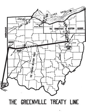
The Lenapé Nation no longer lives in the Cuyahoga Valley because of many changes and agreements. In 1795, the Treaty of Greenville set the Cuyahoga River as a boundary between Native American lands and European settlements. Later, in 1805, another agreement called the Treaty of Fort Industry meant that about 500,000 acres (200,000 ha) of land, including the park area, was given up. The agreement promised money to the tribes, but a part that allowed them to keep hunting on the land was not followed.
Today, the Lenapé Nation is often called the Delaware Nation. Their main office is in Oklahoma, but some also live in Kansas, Wisconsin, Ontario, Canada, and their original homelands like Pennsylvania.
How the Park Grew Over Time
In the 1870s, people from nearby cities started coming to the valley for fun. They enjoyed carriage rides and boat trips on the canal. By 1880, the Valley Railway offered another way to escape city life.
Real park development began in the 1910s and 1920s with local park districts. In 1929, a businessman named Hayward Kendall donated 430 acres (0.7 sq mi; 1.7 km2) of land. He wanted it to be a park forever, named Virginia Kendall Park after his mother. In the 1930s, the Civilian Conservation Corps (CCC) helped build many park structures. These included the Happy Days Lodge and shelters at places like Octagon and Kendall Lake. The Happy Days Lodge was built for city children to use as a camp.
Making Cuyahoga Valley a National Park
By the 1960s, people worried that cities were growing too fast and would spoil the valley's natural beauty. There was also concern about pollution in the Cuyahoga River from factories and sewage. The river even caught fire in 1952 and 1969! Local people worked with government officials to find a lasting solution.
Finally, on December 27, 1974, President Gerald Ford signed a bill to create the Cuyahoga Valley National Recreation Area. Even though some thought it wasn't special enough, it was created to protect the area.
The National Park Service then started buying land for the park. Homes were either purchased or special agreements were made to protect the scenic views.
The National Park Service's Role
In 1985, the National Park Service took over a 47 acres (0.1 sq mi; 0.2 km2) area called the Krejci Dump. It was found to have very harmful materials. The area was closed in 1986 and became a "Superfund" site, meaning it needed a big cleanup. Companies that caused the pollution helped pay for the cleanup. By 2015, the area was cleaned up and restored.
On October 11, 2000, the area officially became the Cuyahoga Valley National Park. This happened after a bill was passed by Congress. The park is managed by the National Park Service. The David Berger National Memorial in Beachwood, Ohio, is also managed by the park.
The Richfield Coliseum, a large sports arena in the area, was taken down in 1999. That land became part of the national park in 2000. Now, it's a grassy field where people enjoy birdwatching.
In 2024, Cuyahoga Valley National Park made a special "sister park" agreement with Dartmoor National Park in England. They plan to work together to improve conservation efforts. This was the first agreement of its kind between the U.S. National Park Service and an English national park.
Amazing Animals and Plants
Wildlife in the Park
Animals you might see in Cuyahoga Valley National Park are common in Ohio. These include raccoons, muskrats, coyotes, skunks, red foxes, beavers, peregrine falcons, river otters, bald eagles, opossums, and white-tailed deer. You can also spot Canada geese, gray foxes, minks, great blue herons, and different kinds of bats.
Plants and Trees
The park is home to many types of trees like maples, oaks, pines, and sycamores. In open areas, you'll find grasses like Kentucky bluegrass. Near water, you might see sedges. Many beautiful flowers bloom in the park, such as spring beauty, yellow trout lily, and Virginia bluebells. Different kinds of ferns, like Christmas ferns and Cinnamon ferns, also grow throughout the park.
Weather in the Valley
The Boston Mill Visitor Center in Cuyahoga Valley National Park has a climate with warm summers. The average coldest temperature in winter is about −6.5 °F (−21.4 °C).
| Climate data for Boston Mill Visitor Center, elevation 722 ft (220 m), 1981–2010 normals, extremes 1981–2019 | |||||||||||||
|---|---|---|---|---|---|---|---|---|---|---|---|---|---|
| Month | Jan | Feb | Mar | Apr | May | Jun | Jul | Aug | Sep | Oct | Nov | Dec | Year |
| Record high °F (°C) | 69.3 (20.7) |
75.7 (24.3) |
82.5 (28.1) |
86.8 (30.4) |
91.5 (33.1) |
101.7 (38.7) |
100.8 (38.2) |
97.6 (36.4) |
93.3 (34.1) |
89.6 (32.0) |
78.5 (25.8) |
75.9 (24.4) |
101.7 (38.7) |
| Mean daily maximum °F (°C) | 34.9 (1.6) |
38.1 (3.4) |
47.1 (8.4) |
59.5 (15.3) |
70.2 (21.2) |
79.6 (26.4) |
83.4 (28.6) |
81.5 (27.5) |
74.8 (23.8) |
63.2 (17.3) |
51.5 (10.8) |
38.9 (3.8) |
60.3 (15.7) |
| Mean daily minimum °F (°C) | 20.7 (−6.3) |
22.3 (−5.4) |
28.9 (−1.7) |
39.6 (4.2) |
49.1 (9.5) |
59.2 (15.1) |
63.4 (17.4) |
62.0 (16.7) |
55.2 (12.9) |
44.7 (7.1) |
35.9 (2.2) |
25.8 (−3.4) |
42.3 (5.7) |
| Record low °F (°C) | −23.3 (−30.7) |
−12.2 (−24.6) |
−5.7 (−20.9) |
14.5 (−9.7) |
29.3 (−1.5) |
37.4 (3.0) |
44.6 (7.0) |
41.3 (5.2) |
35.7 (2.1) |
21.5 (−5.8) |
10.6 (−11.9) |
−14.9 (−26.1) |
−23.3 (−30.7) |
| Average precipitation inches (mm) | 2.43 (62) |
2.08 (53) |
2.77 (70) |
3.35 (85) |
3.92 (100) |
3.84 (98) |
3.94 (100) |
3.56 (90) |
3.51 (89) |
2.88 (73) |
3.27 (83) |
2.87 (73) |
38.42 (976) |
| Average dew point °F (°C) | 20.9 (−6.2) |
22.3 (−5.4) |
28.2 (−2.1) |
37.3 (2.9) |
48.0 (8.9) |
58.0 (14.4) |
62.3 (16.8) |
61.8 (16.6) |
55.3 (12.9) |
43.7 (6.5) |
34.5 (1.4) |
25.3 (−3.7) |
41.6 (5.3) |
| Source: PRISM | |||||||||||||
Fun Things to See and Do
Cuyahoga Valley National Park has a mix of natural wonders, historical sites, and even some private attractions. This is pretty unique for a national park! It includes areas managed by Cleveland Metroparks and Summit Metro Parks.
The park's natural beauty includes forests, rolling hills, deep ravines, wetlands, rivers, and waterfalls. There are about 100 waterfalls in the valley! The most famous is Brandywine Falls, which is 65-foot (20 m) tall and the tallest in the park. The Ledges are cool rock formations that offer great views of the wooded valley. You can also find small caves among the boulders near the Ledges.
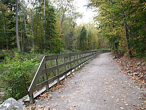
The park has many trails for hiking, biking, and running. The most popular is the 20-mile (32 km) Towpath Trail. It follows the old path of the Ohio and Erie Canal. In winter, you can go skiing and sledding at Kendall Hills. Visitors can also play golf or take a scenic train ride on the Cuyahoga Valley Scenic Railroad during special events.
You can also explore old 19th and early 20th-century farms, like the Hale Farm and Village. The park also hosts art shows, outdoor concerts, and theater performances at places like Blossom Music Center.
The Ohio and Erie Canal Towpath Trail
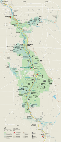
The Ohio and Erie Canal Towpath Trail is a long path developed by the National Park Service. It's the main trail through Cuyahoga Valley National Park. The trail stretches almost 21 mi (34 km) and follows the Cuyahoga River for much of its length. You'll find restrooms and places to get food and drinks along the way. There are also three visitor centers: the Canal Exploration Center, Boston Store, and the Hunt House. The trail connects to other trails, allowing you to go even further north or south.
During certain times of the year, the Cuyahoga Valley Scenic Railroad (CVSR) lets visitors travel along the towpath by train. You can get on or off at different stops. The train is very popular with bicyclists and for seeing the beautiful fall colors.
History of the Canal
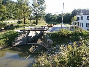
The Towpath Trail follows the historic route of the Ohio and Erie Canal. Before the canal was built (between 1825 and 1832), it was hard to travel and sell crops in Ohio. The canal created a new way to transport goods and people from Cleveland on Lake Erie to Portsmouth on the Ohio River. This connected Ohio to the rest of the eastern United States.
Today, you can walk or ride along the same path where mules once pulled canal boats. You can still see parts of the old canal and learn about its history from signs along the trail. You might even spot signs of beavers living near the water.
Stanford House: A Historic Stay
The Stanford House is a historic farm home built in the 1830s by George Stanford, one of the first settlers in the area. In 1978, the National Park Service bought the property. After renovations, it became the park's first lodging facility in 2011. You can rent the entire house for meetings or overnight stays. There are no other places to stay overnight or camp inside the park.
Towpath Trail Access Points
You can find parking for the Towpath Trail at many places. Some popular spots include:
- Lock 39, west of Rockside Road.
- The Canal Exploration Center, at Hillside Road.
- The Boston Store, east on Boston Mills Road.
- The Peninsula Depot, in the village of Peninsula.
- Lock 28, also called Deep Lock, south of Major Road.
- The Hunt House, at Bolanz Road.
- Ira Road, just north of the intersection.
- Botzum station, south of Bath Road.
The Story of the Land (Geology)
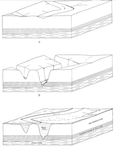
The Cuyahoga River has a very interesting "V" shape. It flows southwest, then suddenly turns north to empty into Lake Erie. The northern part of the "V" follows an older valley that existed before glaciers. The southern part is a newer path. Waterfalls, like those on the Tinkers and Brandywine Creeks, formed as streams cut through softer rock layers.
Long ago, huge glaciers covered this area. When they melted, they left behind thick layers of sand, gravel, and clay, filling the valley up to 400 feet (120 m) deep. You can still see signs of these glaciers today, like the Defiance moraine, a ridge of rocky material.
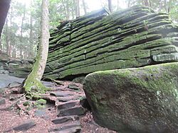
The Ledges are a famous part of the park. They are impressive rock formations made of a strong stone called Sharon Conglomerate. Over time, as softer rock underneath wore away, huge blocks of this strong stone settled, creating cracks and small caves that are fun to explore.
Places to Learn: Visitor Centers
- The Canal Exploration Center is on Canal Road. It has interactive maps and games about the history of the canal, especially from 1825 to 1876. The building used to be a tavern where canal boat passengers waited.
- The Boston Store was built in 1836 and is east of Riverview Road. It was once a warehouse, store, and post office. Now, it's a visitor center with exhibits about building canal boats. You can also watch a short video and get maps.
- The Hunt House at Riverview and Bolanz Roads looks like a family farm from the late 1800s. Here, you can learn about the area's farming history and get information about park activities. It's a great place to start a hike or bike ride.
- The Frazee House on Canal Road was built around 1825, when the canal was being dug. It's a good example of an old Western Reserve home and has exhibits about its architecture and the Frazee family.
Historic Spots to Visit
| Site | Image | Description |
|---|---|---|
| Canal Exploration Center | This center has exhibits about the Ohio and Erie Canal. It's in a renovated building that was once a lively tavern. Lock 38 of the canal is right outside. | |
| Ohio and Erie Canal Structures | The Ohio and Erie Canal was built between 1825 and 1832. It helped Ohio trade with the world. Even though it stopped working after a big flood in 1913, you can still see parts of the old canal and its structures along the Towpath Trail. | |
| Frazee House |  |
The Frazee House was being built in 1825 when the canal was dug right through its front yard. It's a great example of the architectural style from that time. |
| Boston Store (Boston Mill Visitor Center) |  |
This old building from the canal era was owned by the Boston Land and Manufacturing Company. It now has many exhibits about how canal boats were built. |
| Peninsula Depot |  |
The Peninsula Depot is a train station for the Cuyahoga Valley Scenic Railroad. It was moved to Peninsula in the 1960s. It's one of the oldest train stations from the Valley Railway. |
| Everett Covered Bridge |  |
The Everett Covered Bridge is the only covered bridge in Summit County. It was built in 1877. A storm destroyed it in 1975, but the National Park Service rebuilt it in 1986. |
| Brandywine Village |  |
George Wallace started Brandywine Village in 1814 by building a sawmill near Brandywine Falls. More people moved there, and it grew into a small village. You can still see a few old buildings and foundations today. |
| Civilian Conservation Corps Structures |  |
The Civilian Conservation Corps built several structures in the valley in the late 1930s. These include Happy Days Lodge and shelters at the Ledges, Octagon, and Kendall Lake. They were made from American chestnut wood. |
| Stanford House |  |
George Stanford built this beautiful Greek Revival home around 1830. It now serves as a place for meetings and retreats, and also offers overnight stays for visitors. It used to be a youth hostel. |
| Hale Farm and Village |  |
Hale Farm and Village is an outdoor museum where people in costumes show what life was like long ago. It has 21 historic buildings and many skilled craftspeople. You can watch them blow glass, make candles, weave, and more. The farm also has animals and gardens. |
The park also has many other historic sites that are listed on the National Register of Historic Places.
See also
 In Spanish: Parque nacional Valle Cuyahoga para niños
 | Laphonza Butler |
 | Daisy Bates |
 | Elizabeth Piper Ensley |


