Summit County, Ohio facts for kids
Quick facts for kids
Summit County
|
|||
|---|---|---|---|

|
|||
|
|||

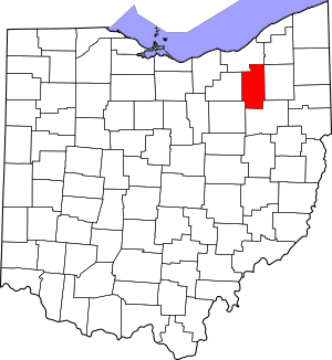
Location within the U.S. state of Ohio
|
|||
 Ohio's location within the U.S. |
|||
| Country | |||
| State | |||
| Founded | March 3, 1840 | ||
| Named for | the highest elevation on the Ohio and Erie Canal | ||
| Seat | Akron | ||
| Largest city | Akron | ||
| Area | |||
| • Total | 419.38 sq mi (1,086.2 km2) | ||
| • Land | 412.08 sq mi (1,067.3 km2) | ||
| • Water | 7.3 sq mi (19 km2) 1.7%% | ||
| Population
(2020)
|
|||
| • Total | 540,428 | ||
| • Estimate
(2022)
|
535,882 |
||
| • Density | 1,288.636/sq mi (497.545/km2) | ||
| Time zone | UTC−5 (Eastern) | ||
| • Summer (DST) | UTC−4 (EDT) | ||
| Congressional district | 13th | ||
Summit County is a busy county located in the state of Ohio in the United States. It is home to many people, with a population of over 540,000 as of 2020. This makes it the fourth-largest county in Ohio by population.
The main city in Summit County is Akron. Akron is also the "county seat," which means it's where the county government offices are located. Summit County was created on March 3, 1840. It was formed from parts of three other counties: Medina, Portage, and Stark.
The county got its name, "Summit," because it has the highest point along the Ohio and Erie Canal. This canal was an important waterway for transportation a long time ago. Summit County is part of the larger Akron metropolitan area. It is also included in the even bigger Cleveland-Akron-Canton area.
Contents
Exploring Summit County's Geography
Summit County covers about 419 square miles. Most of this area, about 412 square miles, is land. The rest, about 7.3 square miles, is water. A big part of Cuyahoga Valley National Park is found in the northern section of the county. This park is a great place to explore nature.
The southern border of an old land area called the Connecticut Western Reserve runs through the southern part of Summit County. This historical boundary causes the county's eastern and western borders to have some interesting jogs or turns.
Major Roads and Highways
Many important roads and highways cross through Summit County. These roads help people travel easily within the county and to other parts of Ohio.
 I-76
I-76 I-77
I-77
 I-80 / Ohio Turnpike
 I-271
I-271 I-277
I-277 I-480
I-480 US 224
 SR 8
SR 8 SR 18
SR 18 SR 21
SR 21 SR 59
SR 59 SR 82
SR 82 SR 91
SR 91 SR 93
SR 93 SR 162
 SR 176
 SR 236
 SR 241
 SR 261
 SR 303
 SR 585
 SR 619
 SR 764
Neighboring Counties
Summit County shares its borders with several other counties in Ohio:
- Cuyahoga County to the northwest
- Geauga County to the northeast
- Portage County to the east
- Stark County to the south
- Wayne County to the southwest
- Medina County to the west
National Parks and Protected Areas
A significant part of Cuyahoga Valley National Park is located in Summit County. This national park offers beautiful natural landscapes and outdoor activities. It also extends north into Cuyahoga County.
Population and People of Summit County
The number of people living in Summit County has changed over the years. Here's a look at the population from past censuses:
| Historical population | |||
|---|---|---|---|
| Census | Pop. | %± | |
| 1840 | 22,560 | — | |
| 1850 | 27,485 | 21.8% | |
| 1860 | 27,344 | −0.5% | |
| 1870 | 34,674 | 26.8% | |
| 1880 | 43,788 | 26.3% | |
| 1890 | 54,089 | 23.5% | |
| 1900 | 71,715 | 32.6% | |
| 1910 | 108,253 | 50.9% | |
| 1920 | 286,065 | 164.3% | |
| 1930 | 344,131 | 20.3% | |
| 1940 | 339,405 | −1.4% | |
| 1950 | 410,032 | 20.8% | |
| 1960 | 513,569 | 25.3% | |
| 1970 | 553,371 | 7.8% | |
| 1980 | 524,472 | −5.2% | |
| 1990 | 514,990 | −1.8% | |
| 2000 | 542,899 | 5.4% | |
| 2010 | 541,781 | −0.2% | |
| 2020 | 540,428 | −0.2% | |
| 2022 (est.) | 535,882 | −1.1% | |
| U.S. Decennial Census 1790-1960 1900-1990 1990-2000 2010-2020 |
|||
In 2010, there were about 541,781 people living in Summit County. There were also over 222,000 households. A household is a group of people living together in one home. About 29.8% of households had children under 18 living with them. The average age of people in the county was 40 years old.
Education in Summit County
Summit County has many schools and places to learn.
Colleges and Universities
For students who want to continue their education after high school, Summit County offers several colleges and universities:
- University of Akron, located in Akron
- Kent State University Twinsburg Academic Center, in Twinsburg
- Stark State College Akron
Fun and Recreation
Summit County has great places for outdoor fun and activities.
- Summit Metro Parks are a system of parks that offer trails for hiking, biking, and other ways to enjoy nature.
Communities in Summit County
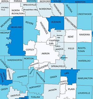
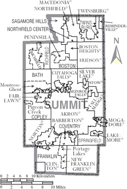
Summit County is made up of many different cities, villages, and townships. Each community has its own unique character.
Cities in Summit County
These are the largest communities in Summit County:
- Akron (This is the county seat!)
- Barberton
- Cuyahoga Falls
- Fairlawn
- Green
- Hudson
- Macedonia
- Munroe Falls
- New Franklin
- Norton (partly in Wayne County)
- Reminderville
- Stow
- Tallmadge
- Twinsburg
Villages in Summit County
Villages are smaller communities within the county:
Townships in Summit County
Townships are areas of land that often include smaller towns or rural areas:
- Bath
- Boston
- Copley
- Coventry
- Northfield Center
- Richfield
- Sagamore Hills
- Springfield
- Twinsburg
Census-Designated Places
These are areas that are like towns but are not officially incorporated as cities or villages:
Unincorporated Communities
These are small communities that are not part of any city or village government:
See also
 In Spanish: Condado de Summit (Ohio) para niños
 | May Edward Chinn |
 | Rebecca Cole |
 | Alexa Canady |
 | Dorothy Lavinia Brown |


