Stark County, Ohio facts for kids
Quick facts for kids
Stark County
|
|||
|---|---|---|---|

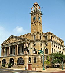
Stark County Courthouse
|
|||
|
|||

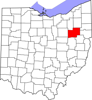
Location within the U.S. state of Ohio
|
|||
 Ohio's location within the U.S. |
|||
| Country | |||
| State | |||
| Founded | January 1, 1809 | ||
| Named for | John Stark | ||
| Seat | Canton | ||
| Largest city | Canton | ||
| Area | |||
| • Total | 581 sq mi (1,500 km2) | ||
| • Land | 575 sq mi (1,490 km2) | ||
| • Water | 5.3 sq mi (14 km2) 0.9%% | ||
| Population
(2020)
|
|||
| • Total | 374,853 | ||
| • Estimate
(2021)
|
373,834 |
||
| • Density | 645.2/sq mi (249.11/km2) | ||
| Time zone | UTC−5 (Eastern) | ||
| • Summer (DST) | UTC−4 (EDT) | ||
| Congressional districts | 6th, 13th | ||
Stark County is a county located in the northeastern part of U.S. state of Ohio. In 2020, about 374,853 people lived there. Its main city, or county seat, is Canton. The county was started in 1808 and officially organized in 1809. It is named after John Stark, a brave officer from the American Revolutionary War.
Stark County is part of a larger area called the Canton-Massillon, OH Metropolitan Statistical Area. This area is also part of the even bigger Cleveland-Akron-Canton, OH Combined Statistical Area.
Contents
History of Stark County
Stark County got its name from American Revolutionary War General John Stark. John Stark was born in 1728 and died in 1822. He was a general in the American Continental Army during the war. He became famous as the "Hero of Bennington" for his great service at the Battle of Bennington in 1777.
In the 1760s and 1770s, Moravian missionaries came to the area. They were from Pennsylvania. They wanted to share their faith with the native people. They also helped native people who had already converted to move away from white settlers. Some of the first missionaries were Christian Frederick Post and John Heckewelder.
The first lasting settlements in Stark County began in 1805. Canton was one of the first. Many early settlers, maybe 80%, spoke German and came from Pennsylvania. Others came from Virginia, New York, and New England. Cutting down trees and sawmills were important early businesses. They provided wood for all the new settlers. Stark County was originally part of Columbiana County. It became its own county in 1807.
When the American Civil War began, men from Stark County quickly volunteered. They wanted to help keep the United States together. By 1862, over 1,100 men from the county had joined the army.
Football History in Stark County
In the early 1900s, Stark County was very important for the start of professional football. There was a big rivalry between the Massillon Tigers and the Canton Bulldogs. This rivalry helped make the Ohio League very popular. The Canton Bulldogs later became one of the first teams in the National Football League. They played in the NFL for several years.
Because of Stark County's role in football history, the Pro Football Hall of Fame is located in Canton. Two large football stadiums are still used today. They are Tom Benson Hall of Fame Stadium in Canton and Paul Brown Tiger Stadium in Massillon. These stadiums are mostly used for high school football. Tom Benson Hall of Fame Stadium also hosts the NFL's yearly Pro Football Hall of Fame Game.
Stark County's Role in Elections
In the later 1900s, Stark County's voting patterns often changed. The county's votes closely matched who won the U.S. Presidential election. Ohio is known as a "swing state," meaning it can vote for either party. Within Ohio, Stark County is seen as a "bellwether." This means it often predicts the national election winner.
Because of this, presidential candidates often visit the area many times. Big news groups also pay close attention to the election results in Stark County. For example, New York Times has written many stories about the county's citizens and their voting concerns for over ten years.
Geography of Stark County
Stark County covers about 581 square miles. Most of this, about 575 square miles, is land. The rest, about 5.3 square miles, is water.
Neighboring Counties
- Portage County (north)
- Mahoning County (northeast)
- Columbiana County (east)
- Carroll County (southeast)
- Tuscarawas County (south)
- Holmes County (southwest)
- Wayne County (west)
- Summit County (northwest)
Main Roads and Highways
 I-77
I-77 US 30
US 30 US 62
US 62 US 250
 SR 21
SR 21 SR 43
SR 43 SR 44
SR 44 SR 93
SR 93 SR 153
 SR 172
 SR 173
 SR 183
 SR 212
 SR 236
 SR 241
 SR 297
 SR 619
 SR 627
 SR 687
 SR 800
Protected Areas
Population and People
| Historical population | |||
|---|---|---|---|
| Census | Pop. | %± | |
| 1810 | 2,734 | — | |
| 1820 | 12,406 | 353.8% | |
| 1830 | 26,588 | 114.3% | |
| 1840 | 34,603 | 30.1% | |
| 1850 | 39,878 | 15.2% | |
| 1860 | 42,978 | 7.8% | |
| 1870 | 52,508 | 22.2% | |
| 1880 | 64,031 | 21.9% | |
| 1890 | 84,170 | 31.5% | |
| 1900 | 94,747 | 12.6% | |
| 1910 | 122,987 | 29.8% | |
| 1920 | 177,218 | 44.1% | |
| 1930 | 221,784 | 25.1% | |
| 1940 | 234,887 | 5.9% | |
| 1950 | 283,194 | 20.6% | |
| 1960 | 340,345 | 20.2% | |
| 1970 | 372,210 | 9.4% | |
| 1980 | 378,823 | 1.8% | |
| 1990 | 367,585 | −3.0% | |
| 2000 | 378,098 | 2.9% | |
| 2010 | 375,586 | −0.7% | |
| 2020 | 374,853 | −0.2% | |
| 2021 (est.) | 373,834 | −0.5% | |
| U.S. decennial census 1790-1960 1900-1990 1990–2000 2010-2020 |
|||
2010 Census Information
In 2010, there were 375,586 people living in Stark County. There were 151,089 households and 100,417 families. The population density was about 653 people per square mile.
Most people in the county were white (88.7%). About 7.6% were black or African American. Other groups included Asian (0.7%), American Indian (0.3%), and people from two or more races (2.2%). About 1.6% of the population was Hispanic or Latino.
Many people in Stark County have German roots (33.6%). Other common backgrounds include Irish (15.5%), English (10.1%), and Italian (10.1%).
About 30.2% of households had children under 18 living with them. About 49.2% were married couples. The average household had 2.42 people. The average family had 2.96 people. The average age in the county was 41.1 years old.
The average income for a household was $44,941. For a family, it was $55,976. About 12.7% of all people in the county lived below the poverty line. This included 19.5% of those under 18.
Education in Stark County
Colleges and Universities
- Kent State University at Stark
- Malone University
- Stark State College
- University of Mount Union
- Walsh University
Technical and Career Centers
- R. G. Drage Career Technical Center
- Sours Adult Career & Technical Center
Public School Districts
- Alliance City School District
- Canton City School District
- Canton Local School District
- Fairless Local School District
- Jackson Local School District
- Lake Local School District
- Louisville City School District
- Marlington Local School District
- Massilon City School District
- Minerva Local School District
- North Canton City School District
- Northwest Local School District
- Osnaburg Local School District
- Perry Local School District
- Plain Local School District
- Sandy Valley Local School District
- Tuslaw Local School District
Private School Districts
- Stark County Catholic Schools
High Schools
- Alliance High School
- Canton McKinley High School
- Canton South High School
- Central Catholic High School
- Early College High School
- East Canton High School
- Fairless High School
- GlenOak High School
- Hoover High School
- Indian River High School
- Jackson High School
- Lake Center Christian School
- Lake Middle/High School
- Louisville High School
- Marlington High School
- Massillon Christian School
- Minerva High School
- Northwest High School
- Perry High School
- St. Thomas Aquinas High School
- Washington High School
Communities in Stark County
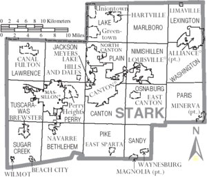
Cities
- Alliance
- Canal Fulton
- Canton (county seat)
- Louisville
- Massillon
- North Canton
Villages
Townships
Before 1815, Stark County had only eight large townships. After some changes, the townships now are:
- Bethlehem
- Canton
- Jackson
- Lake
- Lawrence
- Lexington
- Marlboro
- Nimishillen
- Osnaburg
- Paris
- Perry
- Pike
- Plain
- Sandy
- Sugar Creek
- Tuscarawas
- Washington
Census-Designated Places
These are areas that are not officially cities or villages but are recognized for census purposes:
Unincorporated Communities
These are small communities that are not part of any city, village, or census-designated place:
See also
 In Spanish: Condado de Stark (Ohio) para niños
 | Sharif Bey |
 | Hale Woodruff |
 | Richmond Barthé |
 | Purvis Young |


