Uniontown, Ohio facts for kids
Quick facts for kids
Uniontown, Ohio
|
|
|---|---|
 |
|

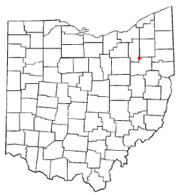
Location of Uniontown, Ohio
|
|

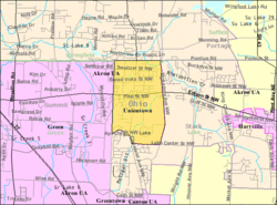
Detailed map of Uniontown
|
|
| Country | United States |
| State | Ohio |
| County | Stark Summit |
| Township | Lake |
| Area | |
| • Total | 4.20 sq mi (10.89 km2) |
| • Land | 4.18 sq mi (10.83 km2) |
| • Water | 0.02 sq mi (0.06 km2) |
| Elevation | 1,132 ft (345 m) |
| Population
(2020)
|
|
| • Total | 7,173 |
| • Density | 1,715.21/sq mi (662.21/km2) |
| Time zone | UTC-5 (Eastern (EST)) |
| • Summer (DST) | UTC-4 (EDT) |
| ZIP code |
44685
|
| Area code(s) | 330 |
| FIPS code | 39-78736 |
| GNIS feature ID | 2393262 |
Uniontown is a small community located in Stark County, Ohio, in the United States. It is known as a census-designated place (CDP), which means it's an area identified by the United States Census Bureau for statistics, but it's not an officially incorporated town or city. In 2020, about 7,173 people lived in Uniontown. It is part of the larger Canton-Massillon metropolitan area.
Contents
History of Uniontown
Uniontown was first planned out in 1816. Its name, "Union," came from two important stagecoach lines that met near where the town was first built. Stagecoaches were like old-fashioned buses that carried people and mail.
By the 1830s, Uniontown had grown quite a bit. It had a church, a schoolhouse, and a place where leather was made (called a tannery). There was also a tavern, which was a type of inn or pub, and two stores where people could buy supplies. A post office has been serving the community since 1920.
Environmental Cleanup Site
South of Uniontown, there was once a large area called the Industrial Excess Landfill (IEL). This site used to be a pit where sand and gravel were dug out. In 1966, it was turned into a landfill, a place where waste is buried.
The landfill accepted many different types of waste. This included solid and liquid waste from factories in nearby Akron, Ohio, as well as other industrial materials. The landfill stopped taking waste in 1980.
After it closed, the landfill caused pollution in the soil and groundwater. Groundwater is the water found underground in cracks and spaces in soil, sand, and rock. Because of this pollution, the U.S. Environmental Protection Agency (EPA) listed the IEL as a Superfund site in 1984. A Superfund site is a place that has been polluted by hazardous waste and needs a special cleanup.
The EPA found that polluted water was spreading from the site in all directions. To help protect people, a system was put in place to control harmful vapors in areas where people lived nearby. Cleanup efforts began, and by 2004, the EPA believed the main cleanup was finished.
Geography and Location
Uniontown is located near the Tuscarawas River. This river is an important waterway in Ohio.
According to the United States Census Bureau, Uniontown covers a total area of about 2.5 square miles (6.5 square kilometers). Most of this area is land, with a very small part being water.
Population Information
| Historical population | |||
|---|---|---|---|
| Census | Pop. | %± | |
| 2020 | 7,173 | — | |
| U.S. Decennial Census | |||
Uniontown is part of the Canton-Massillon, OH Metropolitan Statistical Area. This means it's part of a larger region that includes the cities of Canton and Massillon.
In 2000, there were 2,802 people living in Uniontown. About 26% of the homes had children under 18 living there. Most households were married couples living together. The average age of people in Uniontown in 2000 was 44 years old.
Education in Uniontown
Uniontown has a public library. It is a branch of the Stark County District Library system. This library provides books, resources, and programs for the community.
See also
 In Spanish: Uniontown (Ohio) para niños
 | Selma Burke |
 | Pauline Powell Burns |
 | Frederick J. Brown |
 | Robert Blackburn |

