Harrison County, Ohio facts for kids
Quick facts for kids
Harrison County
|
|||
|---|---|---|---|
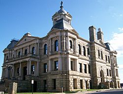
Harrison County Courthouse
|
|||
|
|||
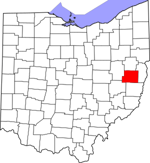
Location within the U.S. state of Ohio
|
|||
 Ohio's location within the U.S. |
|||
| Country | |||
| State | |||
| Founded | February 1, 1813 | ||
| Named for | William Henry Harrison | ||
| Seat | Cadiz | ||
| Largest village | Cadiz | ||
| Area | |||
| • Total | 411 sq mi (1,060 km2) | ||
| • Land | 402 sq mi (1,040 km2) | ||
| • Water | 8.4 sq mi (22 km2) 2.1%% | ||
| Population
(2020)
|
|||
| • Total | 14,483 |
||
| • Density | 35/sq mi (14/km2) | ||
| Time zone | UTC−5 (Eastern) | ||
| • Summer (DST) | UTC−4 (EDT) | ||
| Congressional district | 6th | ||
Harrison County is a county in the state of Ohio, USA. It is located in the eastern part of Ohio. In 2020, about 14,483 people lived here. This makes it one of the counties with fewer people in Ohio.
The main town and largest village in Harrison County is Cadiz. The county got its name from General William Henry Harrison. He was a hero in a war and later became a U.S. President.
Contents
History of Harrison County
Harrison County was created in 1813. It was formed from parts of two other counties: Jefferson and Tuscarawas. The county was named after General William Henry Harrison. He was famous for his actions in the War of 1812. He later became the ninth President of the United States.
In 1895, oil was found near Jewett, Ohio. More oil was discovered in the Scio, Ohio area in 1898. This led to an "oil boom" in Scio. However, by 1901, the oil boom in Scio had mostly ended.
Geography and Nature
According to the U.S. Census Bureau, Harrison County covers about 411 square miles. Most of this area, about 402 square miles, is land. The rest, about 8.4 square miles, is water.
In 2013, it was reported that the ground under Harrison County might hold a lot of "tight oil." This type of oil is trapped in rock layers. To get it out, special methods like horizontal drilling are used. This could mean important natural resources for the county.
Neighboring Counties
Harrison County shares borders with several other counties:
- Carroll County (to the north)
- Jefferson County (to the east)
- Belmont County (to the south)
- Guernsey County (to the southwest)
- Tuscarawas County (to the west)
Conotton Creek Trail
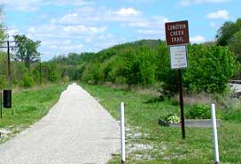
The Conotton Creek Trail is a special path built on old railroad lines. It follows Conotton Creek in northern Harrison County. The trail goes from Bowerston to Jewett. It is a paved path, great for walking or biking. The trail is about 11.4 miles long.
Population and People
| Historical population | |||
|---|---|---|---|
| Census | Pop. | %± | |
| 1820 | 14,345 | — | |
| 1830 | 20,916 | 45.8% | |
| 1840 | 20,099 | −3.9% | |
| 1850 | 20,157 | 0.3% | |
| 1860 | 19,110 | −5.2% | |
| 1870 | 18,682 | −2.2% | |
| 1880 | 20,456 | 9.5% | |
| 1890 | 20,830 | 1.8% | |
| 1900 | 20,486 | −1.7% | |
| 1910 | 19,076 | −6.9% | |
| 1920 | 19,625 | 2.9% | |
| 1930 | 18,844 | −4.0% | |
| 1940 | 20,313 | 7.8% | |
| 1950 | 19,054 | −6.2% | |
| 1960 | 17,995 | −5.6% | |
| 1970 | 17,013 | −5.5% | |
| 1980 | 18,152 | 6.7% | |
| 1990 | 16,085 | −11.4% | |
| 2000 | 15,856 | −1.4% | |
| 2010 | 15,864 | 0.1% | |
| 2020 | 14,483 | −8.7% | |
| U.S. Decennial Census 1790-1960 1900-1990 1990-2000 2020 |
|||
In 2010, about 15,864 people lived in Harrison County. There were 6,526 homes and 4,452 families. The population density was about 39 people per square mile. Most people living in the county were white (95.9%). About 2.1% were black or African American.
Many households (28.1%) had children under 18 living with them. The average age of people in the county was 44.4 years old. The average income for a household was about $35,363 per year.
Communities in Harrison County
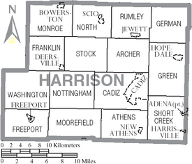
Harrison County has several towns and smaller communities.
Villages
- Adena
- Bowerston
- Cadiz (This is the county seat, where the main government offices are)
- Deersville
- Freeport
- Harrisville
- Hopedale
- Jewett
- New Athens
- Scio
Townships
- Archer
- Athens
- Cadiz
- Franklin
- Freeport
- German
- Green
- Monroe
- Moorefield
- North
- Nottingham
- Rumley
- Short Creek
- Stock
- Washington
Census-designated place
Unincorporated communities
Famous People from Harrison County
Many notable people have connections to Harrison County:
- John Bingham - He was a Congressman. He helped write important parts of the Fourteenth Amendment to the U.S. Constitution.
- Benjamin Cowen - He was an Assistant Secretary of the Interior. He played a key role in setting up Yellowstone National Park. He also promoted the idea that national parks are for everyone.
- George Custer - He was a military leader who served in the American Civil War. He was later killed in the Battle of Little Big Horn.
- Thomas Custer - He received the Medal of Honor, a very brave award. He was George Custer's brother.
- Clark Gable - A very famous actor.
- William Henry Holmes - He was an expert in many fields, including anthropology (the study of human societies), archaeology (the study of human history through digging up old sites), and geology (the study of Earth's physical structure). He also directed museums.
- Edwin Stanton - He was the Secretary of War during Abraham Lincoln's time as president.
See also
 In Spanish: Condado de Harrison (Ohio) para niños
 | Madam C. J. Walker |
 | Janet Emerson Bashen |
 | Annie Turnbo Malone |
 | Maggie L. Walker |


