Belmont County, Ohio facts for kids
Quick facts for kids
Belmont County
|
|||
|---|---|---|---|
|
|||
|
|||
| Motto(s): | |||
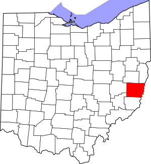
Location within the U.S. state of Ohio
|
|||
 Ohio's location within the U.S. |
|||
| Country | |||
| State | |||
| Founded | September 7, 1801 (created) November 7, 1801 (organized) |
||
| Named for | "beautiful mountain" in French | ||
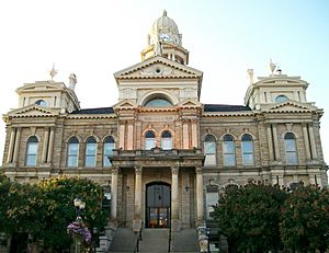
| Seat | St. Clairsville | ||
| Largest city | Martins Ferry | ||
| Area | |||
| • Total | 541.27 sq mi (1,401.9 km2) | ||
| • Land | 532.13 sq mi (1,378.2 km2) | ||
| • Water | 9.14 sq mi (23.7 km2) 1.7%% | ||
| Population
(2020)
|
|||
| • Total | 66,497 |
||
| • Density | 120/sq mi (50/km2) | ||
| Time zone | UTC−5 (Eastern) | ||
| • Summer (DST) | UTC−4 (EDT) | ||
| Congressional district | 6th | ||
Belmont County is a county located in the state of Ohio in the United States. In 2020, about 66,497 people lived here. The main town, called the county seat, is St. Clairsville. The biggest city in the county is Martins Ferry. Belmont County was officially started in 1801. Its name comes from a French phrase meaning "beautiful mountain." It is also part of the larger Wheeling metropolitan area.
Contents
History of Belmont County
Belmont County was created in September 1801. It was formed from parts of Jefferson and Washington counties. Two months later, it was officially organized. St. Clairsville became the county seat in 1803.
Over time, parts of Belmont County were used to form other counties. In 1810, some land went to Guernsey County. In 1813, more land was used for Monroe County. Since 1813, the county's borders have stayed the same. The name Belmont means "beautiful mountain" in French.
Early settlers came to the county using paths like Zane's Trace. Later, the National Road was built through the area. Many of the first settlers were Quakers. These people were strong opponents of slavery. One famous abolitionist, Benjamin Lundy, was among them.
Coal and Glass Industries
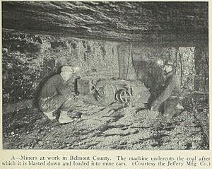
Belmont County is in Ohio's coal region. Long ago, steamships on the Ohio River would stop in Bellaire for coal. By 1866, railroads also served the county. These transportation links, along with coal and skilled workers, made the county a great place for glass factories.
The first glass factory was Excelsior Glass Works, started in 1849. In 1866, Belmont Glass Company opened in Bellaire. It was the first of many glass plants there. Bellaire became known as "Glass City" because it had 15 glass factories by 1881. Ohio was a leading state in glass production, and Belmont County was very important to this industry.
Fun Events and Symbols
Belmont County was home to the famous Jamboree in the Hills. This outdoor country music festival took place every year from 1977 to 2018. In 1986, the county held a special election. People voted for a new official county seal and flag. These were designed by Michael Massa, who lived in the county.
Geography of Belmont County
Belmont County is located on the eastern side of Ohio. Its eastern border is next to West Virginia, across the Ohio River. The Ohio River flows south along the county's eastern edge. Captina Creek and McMahon Creek also flow through the county. They both empty into the Ohio River.
The county has gentle, rolling hills with many small streams. Most of the land is used for farming. The highest point in the county is Galloway Knob, which is about 1,396 feet (426 meters) above sea level. The county covers a total area of about 541 square miles (1492 square kilometers). Most of this is land, with a small part being water.
Neighboring Counties
- Harrison County – north
- Jefferson County – northeast
- Ohio County, West Virginia – east
- Marshall County, West Virginia – southeast
- Monroe County – south
- Noble County – southwest
- Guernsey County – west
Main Roads
Parks and Natural Areas
- Barkcamp State Park
- Dysart Woods Natural Monument
- Egypt Valley Wildlife Area
Lakes in the County
- Barnesville Lake
- Barnesville Reservoir #3
- Belmont Lake
- Piedmont Lake (part)
Population Information
| Historical population | |||
|---|---|---|---|
| Census | Pop. | %± | |
| 1810 | 11,097 | — | |
| 1820 | 20,329 | 83.2% | |
| 1830 | 28,627 | 40.8% | |
| 1840 | 30,901 | 7.9% | |
| 1850 | 34,600 | 12.0% | |
| 1860 | 36,398 | 5.2% | |
| 1870 | 39,714 | 9.1% | |
| 1880 | 49,638 | 25.0% | |
| 1890 | 57,413 | 15.7% | |
| 1900 | 60,875 | 6.0% | |
| 1910 | 76,856 | 26.3% | |
| 1920 | 93,193 | 21.3% | |
| 1930 | 94,719 | 1.6% | |
| 1940 | 95,614 | 0.9% | |
| 1950 | 87,740 | −8.2% | |
| 1960 | 83,864 | −4.4% | |
| 1970 | 80,917 | −3.5% | |
| 1980 | 82,569 | 2.0% | |
| 1990 | 71,074 | −13.9% | |
| 2000 | 70,226 | −1.2% | |
| 2010 | 70,400 | 0.2% | |
| 2020 | 66,497 | −5.5% | |
| US Decennial Census 1790–1960 1900–1990 1990–2000 2020 |
|||
According to the 2010 United States census, there were 70,400 people living in Belmont County. About 28,679 households were counted. The population density was about 132 people per square mile. Most of the people living in the county were white (94.0%). About 4.0% were black or African American.
The average age of people in the county was 43.4 years old. About 27.2% of households had children under 18 living with them. The average household had 2.32 people.
Education in Belmont County
Belmont County has many schools for students from kindergarten through 12th grade. It also has colleges for higher education.
Schools for K–12 Students
- Barnesville Exempted Village School District
- Bellaire High School
- Belmont County Educational Service Center
- Bridgeport High School
- Buckeye Local High School
- East Richland Christian School
- Harrison Central High School
- Martins Ferry High School
- Olney Friends School
- Saint Clairsville High School
- Shadyside High School
- Union Local High School
- Powhatan Elementary School in Powhatan Point
Colleges and Universities
- Belmont College
- Ohio University Eastern Campus
Communities in Belmont County
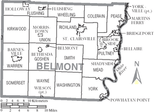
Belmont County has several cities, villages, and smaller communities.
Cities
- Martins Ferry
- St. Clairsville (county seat)
Villages
Census-Designated Places
These are special areas that are like towns but not officially incorporated.
Unincorporated Communities
These are smaller places that are not officially part of a city or village.
- Alledonia
- Anvil
- Armstrongs Mills
- Badgertown
- Barton
- Blaine
- Boston
- Businessburg
- Captina
- Centerville
- Colerain
- Crescent
- Dilles Bottom
- Egypt
- Fairpoint
- Farmington
- Hendrysburg
- Hunter
- Jacobsburg
- Key
- Lamira
- Lloydsville
- Maynard
- McClainville
- Pleasant Grove
- Riverview
- Sewellsville
- Somerton
- Steinersville
- Stewartsville
- Tacoma
- Temperanceville
- Uniontown
- Warnock
Townships
Belmont County is divided into several townships.
- Colerain
- Flushing
- Goshen
- Kirkwood
- Mead
- Pease
- Pultney
- Richland
- Smith
- Somerset
- Union
- Warren
- Washington
- Wayne
- Wheeling
- York
Famous People from Belmont County
Many notable people have come from Belmont County.
- James E. Boyd (1834–1906) – He was a mayor of Omaha and a governor of Nebraska.
- William Boyd (1895–1972) – A film and radio actor, famous for playing the Western character Hopalong Cassidy.
- Don Fleming (1937–1963) – A football player for the University of Florida and the Cleveland Browns. He graduated from Shadyside High School.
- Joey Galloway (1971) – Played football for Ohio State and in the NFL for 15 years. He graduated from Bellaire High School.
- John Havlicek (1940–2019) – A basketball player for Ohio State and the Boston Celtics. He is in the Hall of Fame. He graduated from Bridgeport High School.
- Bushrod Johnson (1817–1880) – One of the few generals for the Confederate States of America who was born in the North.
- Lance Mehl (born 1958) – An NFL football player born in Bellaire.
- Stan Olejniczak (1912–1979) – An NFL football player born in Neffs.
- Wilson Shannon (1802–1877) – The first governor of Ohio who was born in Ohio.
- Drusilla Wilson (1815–1908) – A leader in the temperance movement and a Quaker preacher.
See also
 In Spanish: Condado de Belmont para niños
 | Kyle Baker |
 | Joseph Yoakum |
 | Laura Wheeler Waring |
 | Henry Ossawa Tanner |


