Noble County, Ohio facts for kids
Quick facts for kids
Noble County
|
|||
|---|---|---|---|
|
County
|
|||

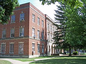
The Noble County Courthouse in Caldwell in 2007
|
|||
|
|||

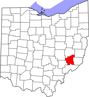
Location within the U.S. state of Ohio
|
|||
 Ohio's location within the U.S. |
|||
| Country | |||
| State | |||
| Founded | April 1, 1851 | ||
| Named for | either James Noble or Warren P. Noble | ||
| Seat | Caldwell | ||
| Largest village | Caldwell | ||
| Area | |||
| • Total | 405 sq mi (1,050 km2) | ||
| • Land | 398 sq mi (1,030 km2) | ||
| • Water | 6.6 sq mi (17 km2) 1.6%% | ||
| Population
(2020)
|
|||
| • Total | 14,115 | ||
| • Estimate
(2021)
|
14,176 |
||
| • Density | 34.85/sq mi (13.456/km2) | ||
| Time zone | UTC−5 (Eastern) | ||
| • Summer (DST) | UTC−4 (EDT) | ||
| Congressional district | 6th | ||
Noble County is a county located in the southeastern part of Ohio. As of the 2020 census, about 14,115 people lived there. This makes it one of the least populated counties in Ohio. Its main town, or county seat, is Caldwell. The county is named after Warren P. Noble, who was an early settler and a representative in the Ohio House.
Contents
History of Noble County
Noble County was formed on March 11, 1851. It was created from parts of four other counties: Guernsey, Morgan, Monroe, and Washington. It was the very last county to be formed in the state of Ohio. The county was named after either James Noble or Warren P. Noble. Both were early settlers in this area.
First Oil Well
Noble County was home to a very important discovery. The first North American oil well was found here. It was called the Thorla-McKee Well. Oil was struck in 1814, which means they found oil there. For a while, this area was a major center for oil production in Ohio.
USS Shenandoah Airship Crash
In 1925, a large United States Navy dirigible (a type of airship) called the USS Shenandoah (ZR-1) was flying over Noble County. It got caught in a severe storm. The airship broke apart into several pieces. Sadly, 14 people on board died in the accident. However, 29 people survived the crash.
Geography of Noble County
Noble County covers a total area of about 405 square miles (405 square miles (1,050 km2)). Most of this area, about 398 square miles (398 square miles (1,030 km2)), is land. The remaining 6.6 square miles (6.6 square miles (17 km2)) is water, which is about 1.6% of the total area.
Neighboring Counties
Noble County shares its borders with several other counties:
- Guernsey County (to the north)
- Belmont County (to the northeast)
- Monroe County (to the east)
- Washington County (to the south)
- Morgan County (to the west)
- Muskingum County (to the northwest)
Protected Natural Areas
A part of the Wayne National Forest is located within Noble County. This is a large protected area of natural land.
Population and People
| Historical population | |||
|---|---|---|---|
| Census | Pop. | %± | |
| 1860 | 20,751 | — | |
| 1870 | 19,949 | −3.9% | |
| 1880 | 21,138 | 6.0% | |
| 1890 | 20,753 | −1.8% | |
| 1900 | 19,466 | −6.2% | |
| 1910 | 18,601 | −4.4% | |
| 1920 | 17,849 | −4.0% | |
| 1930 | 14,961 | −16.2% | |
| 1940 | 14,587 | −2.5% | |
| 1950 | 11,750 | −19.4% | |
| 1960 | 10,982 | −6.5% | |
| 1970 | 10,428 | −5.0% | |
| 1980 | 11,310 | 8.5% | |
| 1990 | 11,336 | 0.2% | |
| 2000 | 14,058 | 24.0% | |
| 2010 | 14,645 | 4.2% | |
| 2020 | 14,115 | −3.6% | |
| 2021 (est.) | 14,176 | −3.2% | |
| U.S. Decennial Census 1790-1960 1900-1990 1990-2000 2010-2020 |
|||
2010 Census Information
In 2010, there were 14,645 people living in Noble County. These people lived in 4,852 households. About 3,394 of these were families. The county had about 36.8 people per square mile (36.8 inhabitants per square mile (14.2/km2)).
Most of the people in the county were white (96.1%). About 2.5% were black or African American. A small number were American Indian (0.3%) or Asian (0.1%). About 0.4% of the population was of Hispanic or Latino origin.
The average age of people in Noble County was 48.6 years old. About 30.4% of households had children under 18 living with them.
Education in Noble County
Students in Noble County are served by two main school districts. These are the Caldwell Exempted Village School District and the Noble Local School District.
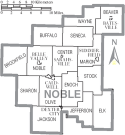
Communities in Noble County
Noble County has several different types of communities.
Villages
- Batesville
- Belle Valley
- Caldwell (This is the county seat, the main town)
- Dexter City
- Sarahsville
- Summerfield
Townships
- Beaver
- Brookfield
- Buffalo
- Center
- Elk
- Enoch
- Jackson
- Jefferson
- Marion
- Noble
- Olive
- Seneca
- Sharon
- Stock
- Wayne
Unincorporated Communities
These are smaller communities that are not officially organized as villages or cities.
- Ava
- Carlisle
- Crooked Tree
- Dudley
- Dungannon
- East Union
- Elk
- Fulda
- Gem
- Harriettsville
- Hiramsburg
- Honesty
- Hoskinsville
- Keith
- Kennonsburg
- Middleburg
- Moundsville
- Mount Ephraim
- Olive Green
- Rochester
- Sharon
- South Olive
- Steamtown
- Whigville
See also
 In Spanish: Condado de Noble (Ohio) para niños
 | Calvin Brent |
 | Walter T. Bailey |
 | Martha Cassell Thompson |
 | Alberta Jeannette Cassell |


