Washington County, Ohio facts for kids
Quick facts for kids
Washington County
|
|||
|---|---|---|---|
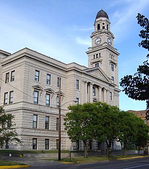
Washington County Courthouse
|
|||
|
|||
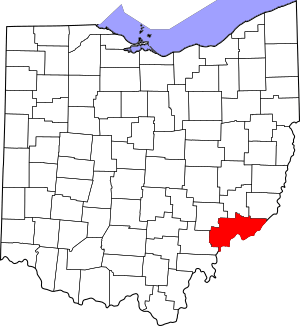
Location within the U.S. state of Ohio
|
|||
 Ohio's location within the U.S. |
|||
| Country | |||
| State | |||
| Founded | July 27, 1788 | ||
| Named for | George Washington | ||
| Seat | Marietta | ||
| Largest city | Marietta | ||
| Area | |||
| • Total | 640 sq mi (1,700 km2) | ||
| • Land | 632 sq mi (1,640 km2) | ||
| • Water | 8.0 sq mi (21 km2) 1.3%% | ||
| Population
(2020)
|
|||
| • Total | 59,711 |
||
| • Density | 93/sq mi (36/km2) | ||
| Time zone | UTC−5 (Eastern) | ||
| • Summer (DST) | UTC−4 (EDT) | ||
| Congressional district | 6th | ||
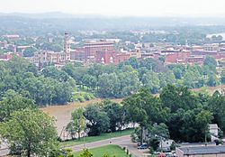
Washington County is a cool place in the southeastern part of Ohio, a state in the United States. It's a type of area called a county. In 2020, about 59,711 people lived here. Its main city, called the county seat, is Marietta.
Washington County is the oldest county in Ohio! It was named after George Washington, who was the first president of the United States. The county is part of a larger area that includes Parkersburg-Marietta-Vienna, which stretches into West Virginia.
Contents
Exploring Washington County's Geography
Washington County covers a total area of about 640 square miles. Most of this area, about 632 square miles, is land. The rest, about 8 square miles, is water. This makes it the fifth-largest county in Ohio by land size.
Rivers and Waterways
The southern and eastern edge of Washington County is formed by the Ohio River. This is a very important river! Other rivers and creeks also flow through the county. These include the Muskingum River, Little Muskingum River, Duck Creek, and the Little Hocking River. All of these eventually join the Ohio River.
Neighboring Counties
Washington County shares its borders with several other counties.
- To the north: Noble County
- To the northeast: Monroe County
- To the east: Tyler County, West Virginia
- To the southeast: Pleasants County, West Virginia
- To the south: Wood County, West Virginia
- To the southwest: Athens County
- To the northwest: Morgan County
Main Roads and Highways
Many important roads help people travel through Washington County. These include:
 I-77
I-77 US 50
US 50 SR 7
SR 7 SR 26
SR 26 SR 60
SR 60 SR 145
 SR 260
 SR 339
 SR 530
 SR 550
 SR 555
 SR 676
 SR 821
Special Natural Areas
Part of the Wayne National Forest is located in Washington County. This is a large forest area where people can enjoy nature. There's also the Boord State Nature Preserve, which helps protect local plants and animals.
People of Washington County
| Historical population | |||
|---|---|---|---|
| Census | Pop. | %± | |
| 1800 | 5,427 | — | |
| 1810 | 5,991 | 10.4% | |
| 1820 | 10,425 | 74.0% | |
| 1830 | 11,731 | 12.5% | |
| 1840 | 20,823 | 77.5% | |
| 1850 | 29,540 | 41.9% | |
| 1860 | 36,268 | 22.8% | |
| 1870 | 40,609 | 12.0% | |
| 1880 | 43,244 | 6.5% | |
| 1890 | 42,380 | −2.0% | |
| 1900 | 48,245 | 13.8% | |
| 1910 | 45,422 | −5.9% | |
| 1920 | 43,049 | −5.2% | |
| 1930 | 42,437 | −1.4% | |
| 1940 | 43,537 | 2.6% | |
| 1950 | 44,407 | 2.0% | |
| 1960 | 51,689 | 16.4% | |
| 1970 | 57,160 | 10.6% | |
| 1980 | 64,266 | 12.4% | |
| 1990 | 62,254 | −3.1% | |
| 2000 | 63,251 | 1.6% | |
| 2010 | 61,778 | −2.3% | |
| 2020 | 59,711 | −3.3% | |
| U.S. Decennial Census 1790-1960 1900-1990 1990-2000 2020 |
|||
In 2010, about 61,778 people lived in Washington County. Most people were white, and smaller groups included Black or African American, Asian, and American Indian people. Some people were also from two or more racial backgrounds. A small percentage of the population was of Hispanic or Latino origin.
Many families live in the county. The average age of people living here was about 43 years old. The average income for a family was around $53,131 per year.
Learning and Education
Washington County has many schools for students of all ages.
High Schools
As of 2016, there are six high schools in Washington County:
- Belpre Golden Eagles
- Beverly Fort Frye Cadets
- New Matamoras Frontier Cougars
- Marietta Tigers
- Vincent Warren Warriors
- Waterford Wildcats
Colleges and Career Training
For students who want to continue their education after high school, there are several options:
- The Washington County Career Center is a school that teaches job skills.
- Washington State Community College offers two-year college programs.
- Marietta College is a four-year college.
All of these higher education schools are located in the city of Marietta.
Communities in Washington County
Washington County has different types of communities, from bigger cities to smaller villages and townships.
Cities
Villages
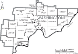
Townships
Townships are smaller local government areas within the county.
- Adams
- Aurelius
- Barlow
- Belpre
- Decatur
- Dunham
- Fairfield
- Fearing
- Grandview
- Independence
- Lawrence
- Liberty
- Ludlow
- Marietta
- Muskingum
- Newport
- Palmer
- Salem
- Warren
- Waterford
- Watertown
- Wesley
Census-Designated Places (CDPs)
These are areas that are like towns but don't have their own separate local government.
Unincorporated Communities
These are smaller places that are not part of a city or village.
- Archers Fork
- Barlow
- Bartlett
- Beavertown
- Beckett
- Bevan
- Bloomfield
- Bonn
- Briggs
- Caywood
- Churchtown
- Coal Run
- Constitution
- Cornerville
- Cow Run
- Cutler
- Dalzell
- Dart
- Decaturville
- Deucher
- Dunbar
- Dunham
- Elba
- Equity
- Fillmore
- Fleming
- Germantown
- Gracey
- Grandview
- Layman
- Leith
- Lower Newport
- Luke Chute
- Moore Junction
- Moss Run
- Newell Run
- Oak Grove
- Patten Mills
- Pinehurst
- Qualey
- Rainbow
- Relief
- Sitka
- Stanleyville
- Tick Ridge
- Veto
- Wade
- Warner
- Watertown
- Whipple
- Wingett Run
- Yankeeburg
See also
 In Spanish: Condado de Washington (Ohio) para niños
 | Charles R. Drew |
 | Benjamin Banneker |
 | Jane C. Wright |
 | Roger Arliner Young |


