Pleasants County, West Virginia facts for kids
Quick facts for kids
Pleasants County
|
|
|---|---|

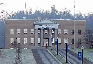
Pleasants County Courthouse in St. Marys
|
|

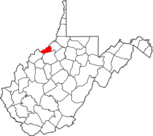
Location within the U.S. state of West Virginia
|
|
 West Virginia's location within the U.S. |
|
| Country | |
| State | |
| Founded | March 29, 1851 |
| Named for | James Pleasants |
| Seat | St. Marys |
| Largest city | St. Marys |
| Area | |
| • Total | 135 sq mi (350 km2) |
| • Land | 130 sq mi (300 km2) |
| • Water | 4.4 sq mi (11 km2) 3.3%% |
| Population
(2020)
|
|
| • Total | 7,653 |
| • Estimate
(2021)
|
7,601 |
| • Density | 56.69/sq mi (21.89/km2) |
| Time zone | UTC−5 (Eastern) |
| • Summer (DST) | UTC−4 (EDT) |
| Congressional district | 1st |
Pleasants County is a county in the state of West Virginia. In 2020, about 7,653 people lived there. The main town, or county seat, is St. Marys.
Contents
History of Pleasants County
Pleasants County was created on March 29, 1851. It was formed from parts of nearby Wood, Ritchie, and Tyler counties. The Virginia General Assembly, which was the state's law-making group, made this decision.
The county is named after James Pleasants, Jr.. He was an important person who used to be a US Senator and the Governor of Virginia.
During the American Civil War, on June 20, 1863, Pleasants County became part of the new state of West Virginia. West Virginia was one of fifty counties that joined the Union during the war.
How Local Government Was Organized
In 1863, West Virginia divided its counties into areas called civil townships. The idea was to help local governments work better. But this system was hard to use in a state with many rural areas.
So, in 1872, these townships were changed into magisterial districts. Pleasants County had six of these districts: Grant, Jefferson, Lafayette, McKim, Union, and Washington. These districts stayed mostly the same for over 100 years.
In the 1980s, the six old districts were combined into four new ones. These are now called District A, District B, District C, and District D.
Geography and Location
Pleasants County covers a total area of about 135 square miles. Most of this area, about 130 square miles, is land. The rest, about 4.4 square miles, is water. This means about 3.3% of the county is water.
Pleasants County is the fourth-smallest county in West Virginia by land area.
Main Roads in the County
Neighboring Counties
Pleasants County shares borders with these other counties:
- Washington County, Ohio (to the north)
- Tyler County (to the east)
- Ritchie County (to the southeast)
- Wood County (to the southwest)
Protected Natural Areas
Part of the Ohio River Islands National Wildlife Refuge is located in Pleasants County. This refuge helps protect wildlife and their homes.
Population and People
| Historical population | |||
|---|---|---|---|
| Census | Pop. | %± | |
| 1860 | 2,945 | — | |
| 1870 | 3,012 | 2.3% | |
| 1880 | 6,256 | 107.7% | |
| 1890 | 7,539 | 20.5% | |
| 1900 | 9,345 | 24.0% | |
| 1910 | 8,074 | −13.6% | |
| 1920 | 7,379 | −8.6% | |
| 1930 | 6,545 | −11.3% | |
| 1940 | 6,692 | 2.2% | |
| 1950 | 6,369 | −4.8% | |
| 1960 | 7,124 | 11.9% | |
| 1970 | 7,274 | 2.1% | |
| 1980 | 8,236 | 13.2% | |
| 1990 | 7,546 | −8.4% | |
| 2000 | 7,514 | −0.4% | |
| 2010 | 7,605 | 1.2% | |
| 2020 | 7,653 | 0.6% | |
| 2021 (est.) | 7,601 | −0.1% | |
| U.S. Decennial Census 1790–1960 1900–1990 1990–2000 2010–2020 |
|||
2020 Population Count
In the 2020 United States census, there were 7,653 people living in Pleasants County. There were 2,688 households, which are groups of people living together.
Most people, about 94.7%, were White. About 1.2% were African American, and smaller groups were Asian or Native American. Some people identified as being from other races or from two or more races. About 0.8% of the population was Hispanic or Latino.
The average age in the county was 43.1 years. About 19.2% of the people were under 18 years old.
2010 Population Count
The 2010 United States census counted 7,605 people in the county. There were 2,861 households.
About 97.3% of the people were white. Other groups included 1.3% black or African American, and 0.2% American Indian. About 0.8% of the population was Hispanic or Latino.
The average age was 42.4 years. About 31.0% of households had children under 18 living with them.
Education in Pleasants County
Pleasants County has one school district. This district includes one high school, one middle school, and two elementary schools.
The county also has the Mid Ohio Valley Technical Institute. This institute offers special training for jobs in many different areas.
Communities in Pleasants County
Cities
Towns
Magisterial Districts
Current Districts
- District A
- District B
- District C
- District D
Historic Districts
- Grant
- Jefferson
- Lafayette
- McKim
- Union
- Washington
Unincorporated Communities
These are smaller communities that are not officially cities or towns:
See also
 In Spanish: Condado de Pleasants para niños
 | Emma Amos |
 | Edward Mitchell Bannister |
 | Larry D. Alexander |
 | Ernie Barnes |

