Ritchie County, West Virginia facts for kids
Quick facts for kids
Ritchie County
|
|
|---|---|

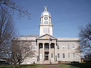
Ritchie County Courthouse in Harrisville
|
|

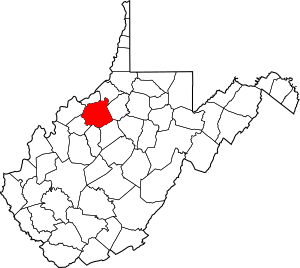
Location within the U.S. state of West Virginia
|
|
 West Virginia's location within the U.S. |
|
| Country | |
| State | |
| Founded | February 18, 1843 |
| Named for | Thomas Ritchie |
| Seat | Harrisville |
| Largest town | Harrisville |
| Area | |
| • Total | 454 sq mi (1,180 km2) |
| • Land | 452 sq mi (1,170 km2) |
| • Water | 1.7 sq mi (4 km2) 0.4%% |
| Population
(2020)
|
|
| • Total | 8,444 |
| • Estimate
(2021)
|
8,383 |
| • Density | 18.599/sq mi (7.181/km2) |
| Time zone | UTC−5 (Eastern) |
| • Summer (DST) | UTC−4 (EDT) |
| Congressional district | 1st |
Ritchie County is a county in the U.S. state of West Virginia. In 2020, about 8,444 people lived here. Its main town, or county seat, is Harrisville. The county was created in 1843 by the Virginia General Assembly. It was named after Thomas Ritchie, a newspaper publisher from Richmond, Virginia.
Contents
History of Ritchie County
Ritchie was one of fifty counties that joined the new state of West Virginia. This happened on June 20, 1863, during the American Civil War. Later that year, the new state divided its counties into areas called townships. This was meant to help local governments.
However, this idea did not work well in West Virginia because it was very rural. So, in 1872, the townships became "magisterial districts." These are smaller areas within a county that help with local government. Ritchie County was divided into four of these districts: Clay, Grant, Murphy, and Union.
In 1911, a historian named Minnie Kendall Lowther wrote a book. It was called "The History of Ritchie County." Her book is still seen as one of the best histories of any county in West Virginia.
Geography and Nature
Ritchie County covers a total area of about 454 square miles (1,176 square kilometers). Most of this area, about 452 square miles (1,171 square kilometers), is land. Only a small part, about 1.7 square miles (4.4 square kilometers), is water.
Main Roads in Ritchie County
Several important roads pass through Ritchie County. These highways help people travel to and from the county.
 U.S. Route 50
 West Virginia Route 16
 West Virginia Route 31
 West Virginia Route 47
 West Virginia Route 74
Neighboring Counties
Ritchie County shares its borders with several other counties. These are:
- Pleasants County (to the north)
- Tyler County (to the northeast)
- Doddridge County (to the east)
- Gilmer County (to the southeast)
- Calhoun County (to the south)
- Wirt County (to the southwest)
- Wood County (to the northwest)
Population Over Time
The number of people living in Ritchie County has changed a lot over the years. Here is a look at the population from different census counts:
| Historical population | |||
|---|---|---|---|
| Census | Pop. | %± | |
| 1850 | 3,902 | — | |
| 1860 | 6,847 | 75.5% | |
| 1870 | 9,055 | 32.2% | |
| 1880 | 13,474 | 48.8% | |
| 1890 | 16,621 | 23.4% | |
| 1900 | 18,901 | 13.7% | |
| 1910 | 17,875 | −5.4% | |
| 1920 | 16,506 | −7.7% | |
| 1930 | 15,594 | −5.5% | |
| 1940 | 15,389 | −1.3% | |
| 1950 | 12,535 | −18.5% | |
| 1960 | 10,877 | −13.2% | |
| 1970 | 10,145 | −6.7% | |
| 1980 | 11,442 | 12.8% | |
| 1990 | 10,233 | −10.6% | |
| 2000 | 10,343 | 1.1% | |
| 2010 | 10,449 | 1.0% | |
| 2020 | 8,444 | −19.2% | |
| 2021 (est.) | 8,383 | −19.8% | |
| U.S. Decennial Census 1790–1960 1900–1990 1990–2000 2010–2020 |
|||
What the 2010 Census Showed
In 2010, there were 10,449 people living in Ritchie County. These people lived in 4,367 households. About 28.2% of these households had children under 18 living with them. The average age of people in the county was 44.3 years old.
Most of the people in the county were white (98.7%). A small number of people were from other racial backgrounds. About 0.5% of the population was of Hispanic or Latino origin. Many people had German, Irish, American, or English family roots.
Fun Places to Visit
Ritchie County has several interesting places to see and visit.
- Historic Berdine's Five and Dime
- North Bend State Park
- North Bend Rail Trail
- The Double Scoop Ice Cream Parlor in Cairo, WV
- Pine Hill Pottery
- Sunny Hollow Farms
- Old Stone House Museum
Communities in Ritchie County
Ritchie County has different types of communities, from cities to small, unincorporated areas.
City
Towns
- Auburn
- Cairo
- Ellenboro
- Harrisville (This is the county seat, where the main government offices are.)
- Pullman
Magisterial Districts
These are the four local government areas within the county:
- Clay
- Grant
- Murphy
- Union
Unincorporated Communities
These are smaller communities that are not officially part of a city or town:
See also
 In Spanish: Condado de Ritchie para niños
 | Toni Morrison |
 | Barack Obama |
 | Martin Luther King Jr. |
 | Ralph Bunche |

