
North Bend Rail Trail facts for kids
Quick facts for kids North Bend Rail Trail State Park |
|
|---|---|

North Bend Rail Trail east of Cairo
|
|

North Bend Rail Trail State Park
Location in West Virginia
|
|
| Location | Doddridge, Harrison, Ritchie & Wood counties, West Virginia, United States |
| Nearest city | Pennsboro, West Virginia |
| Length | 72 mi (116 km) |
| Elevation | 856 ft (261 m) |
| Designated | West Virginia State Park |
| Governing body | West Virginia Division of Natural Resources |
The North Bend Rail Trail is a cool trail in West Virginia. It's about 72 miles long. This trail used to be a railroad line. Now, it's a great place for walking, biking, and even horseback riding!
The trail is managed by West Virginia State Parks. It's also part of the American Discovery Trail. This is a huge trail network that crosses the entire United States.
The North Bend Rail Trail runs next to U.S. Route 50. It starts near Clarksburg in the east. It ends near Parkersburg in the west. Along the way, it goes through four different counties. These are Harrison, Doddridge, Ritchie, and Wood counties.
You'll pass through several towns on the trail. These include Salem, West Union, Pennsboro, Ellenboro, and Cairo. The trail also goes right through North Bend State Park.
History of the Trail
From Railroad to Rail Trail
The North Bend Rail Trail was once a very important railroad line. It was built by the Northwestern Virginia Railroad company. They started building it in 1851. The goal was to connect Grafton, West Virginia to the Ohio River at Parkersburg, West Virginia. This was a distance of 103 miles.
The railroad line was finished on May 1, 1857. It was then sold to the Baltimore & Ohio Railroad (B&O). It became known as the B&O Parkersburg Branch. Engineers built this line very carefully. They made sure it had gentle curves and slopes. This made it easy for trains to travel. There were 23 tunnels and 52 bridges along the route!
In its best years, famous passenger trains used this line. Trains like the Metropolitan and the National Limited traveled here. The National Limited was a top train. It connected New York City to St. Louis, Missouri.
However, more and more people started buying cars. This meant fewer people rode trains. So, in 1971, the B&O stopped running passenger trains. A new company called Amtrak took over some passenger services.
Amtrak tried to bring back passenger trains on this route. They ran trains like the West Virginian and the Shenandoah. But not many people used these trains. So, Amtrak eventually stopped them too. By 1981, there were very few trains left on the line.
The railroad company, which was now called Chessie System, started using other routes. By 1985, they stopped all local train service. In 1987, CSX Transportation took over the line. They decided to close parts of the line. In September 1988, they removed the tracks.
Creating the Trail
After the tracks were removed, the railroad land was empty. CSX Transportation first wanted a lot of money for it. But eventually, they sold it to the state of West Virginia. The state paid about $320,000 for the land.
West Virginia then made plans to turn the old railroad into a fun trail. They wanted it to be part of their state park system. The first parts of the trail opened in 1991. More sections were added over the next few years. This created about 60 miles of trail. It included 50 bridges and 12 tunnels.
In 1996, the state bought even more of the old railroad land. This made the trail 72 miles long. Today, the North Bend Rail Trail is managed by the state's Department of Natural Resources. It has become one of the most famous trails in the Appalachian Mountains. People love it for its beautiful mountain views and long tunnels. One tunnel, Tunnel No. 2 near Salem, is 1,086 feet long!
Images for kids
-
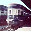
The National Limited train once rode on these tracks.
-
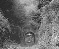
A work train leaving a tunnel near Salem in 1988, as tracks were being removed.
-
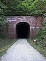
One of the many cool tunnels you'll find on the North Bend Rail Trail.
.jpg)


