Doddridge County, West Virginia facts for kids
Quick facts for kids
Doddridge County
|
|||
|---|---|---|---|

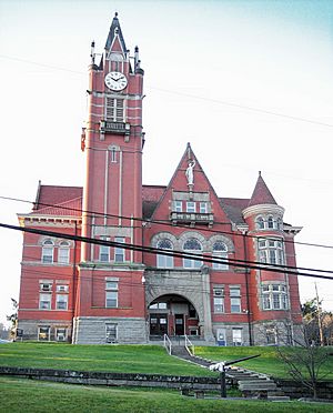
The Doddridge County Courthouse (1899) in West Union
|
|||
|
|||

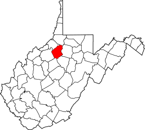
Location within the U.S. state of West Virginia
|
|||
 West Virginia's location within the U.S. |
|||
| Country | |||
| State | |||
| Founded | February 4, 1845 | ||
| Named for | Philip Doddridge | ||
| Seat | West Union | ||
| Largest town | West Union | ||
| Area | |||
| • Total | 320 sq mi (800 km2) | ||
| • Land | 320 sq mi (800 km2) | ||
| • Water | 0.8 sq mi (2 km2) 0.2%% | ||
| Population
(2020)
|
|||
| • Total | 7,808 | ||
| • Estimate
(2021)
|
7,735 |
||
| • Density | 24.4/sq mi (9.42/km2) | ||
| Time zone | UTC−5 (Eastern) | ||
| • Summer (DST) | UTC−4 (EDT) | ||
| Congressional district | 1st | ||
Doddridge County is a county located in the state of West Virginia, United States. In 2020, about 7,808 people lived here. The main town and county seat is West Union.
Doddridge County is also part of the larger Clarksburg, West Virginia, Micropolitan Statistical Area.
Contents
History of Doddridge County
Early Settlers and Life
The land that is now Doddridge County was first settled in the late 1780s. A man named James Caldwell owned a huge amount of land here. Later, in the early 1800s, Nathan Davis, Jr. and his brothers bought much of this land.
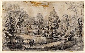
In 1828, Ephraim Bee and his wife Catherine built a log home. They also opened an inn called the "Beehive Inn." This inn became a popular spot for travelers and local people to meet. Ephraim Bee was also the first blacksmith in the area. He built a farm, stables, and even a horse-racing track!
A big flood in 1835 washed away the first bridge over Middle Island Creek. Later, in 1842, a new covered bridge was planned. Ephraim Bee, the blacksmith, made all the metal parts for this bridge, which was finished in 1843.
How the County Was Formed
Doddridge County was officially created in 1845. It was made from parts of four other counties in what was then still Virginia. The county was named after Philip Doddridge. He was an important leader from western Virginia who spoke up for the people in this region.
When the new county was formed, there was a discussion about where the main town, or county seat, should be. Ephraim Bee wanted it to be in Lewisport. But others decided on West Union, which was across the river.
In 1856, the Baltimore and Ohio Railroad came through the county. This helped connect the area to other places. A big fire in 1858 destroyed much of West Union.
West Virginia became its own state in 1863, during the American Civil War.
Districts and Local Government
In 1863, counties in West Virginia were divided into smaller areas called townships. This was meant to help local government. Later, these townships became "magisterial districts." Doddridge County first had six districts. Over time, more were added, and then they were combined into four new districts: Beech, Maple, Oak, and Pine.
There's a local story that a cave called Gatrell Cave on Maxwell Ridge was used by the Underground Railroad. This was a secret network that helped enslaved people escape to freedom before the Civil War. Another cave, Jaco Cave, is also said to have been used for this purpose. This cave was even featured in a movie from the 1970s!
The town of West Union officially became a town on July 20, 1881.
Oil and Gas Boom
The discovery of oil and gas brought a lot of changes to Doddridge County. The first oil well was drilled in 1892. Many farmers and their sons started working in the oil and gas fields. Landowners often received free natural gas piped to their homes. This meant they could use gas for heating, lighting, and cooking, instead of wood stoves and candles.
Later, factories like the Ideal Glass Factory opened in 1906 to use the natural gas. These factories created many jobs.
In June 1950, a major flood hit West Union. It destroyed homes and businesses and sadly caused many deaths across the county. The old covered bridge, which was 107 years old, was also destroyed.
Today, people in Doddridge County work in farming, timber, oil and gas, and for the county government and schools. Many also travel to nearby towns for work.
Several buildings in Doddridge County are listed on the National Register of Historic Places. These include the Lathrop Russell Charter House, the Doddridge County Courthouse, and the Silas P. Smith Opera House. West Union also has two historic districts recognized nationally.
Geography
Doddridge County covers about 320 square miles (829 square kilometers) of land. Only a tiny part, about 0.8 square miles, is water.
Main Roads
Neighboring Counties
Doddridge County shares borders with these counties:
- Wetzel County (north)
- Harrison County (east)
- Lewis County (southeast)
- Gilmer County (south)
- Ritchie County (west)
- Tyler County (northwest)
People of Doddridge County (Demographics)
| Historical population | |||
|---|---|---|---|
| Census | Pop. | %± | |
| 1850 | 2,750 | — | |
| 1860 | 5,203 | 89.2% | |
| 1870 | 7,076 | 36.0% | |
| 1880 | 10,552 | 49.1% | |
| 1890 | 12,183 | 15.5% | |
| 1900 | 13,689 | 12.4% | |
| 1910 | 12,672 | −7.4% | |
| 1920 | 11,976 | −5.5% | |
| 1930 | 10,488 | −12.4% | |
| 1940 | 10,923 | 4.1% | |
| 1950 | 9,026 | −17.4% | |
| 1960 | 6,970 | −22.8% | |
| 1970 | 6,389 | −8.3% | |
| 1980 | 7,433 | 16.3% | |
| 1990 | 6,994 | −5.9% | |
| 2000 | 7,403 | 5.8% | |
| 2010 | 8,202 | 10.8% | |
| 2020 | 7,808 | −4.8% | |
| 2021 (est.) | 7,735 | −5.7% | |
| U.S. Decennial Census 1790–1960 1900–1990 1990–2000 2010–2020 |
|||
In 2010, there were 8,202 people living in Doddridge County. Most people (97%) were white. About 1.4% were Black or African American, and smaller numbers were American Indian or Asian. About 0.5% of the population was of Hispanic or Latino background.
Many people in the county have German, Irish, English, or French Canadian family roots.
The average age of people in the county was about 42.4 years old. About 28.6% of households had children under 18 living with them.
The average income for a family in the county was around $34,016 per year. About 25.1% of all people in the county lived below the poverty line. This included about 36.7% of children under 18.
Communities
Town
- West Union (This is the county seat, meaning it's the main town where the county government is located.)
Magisterial Districts
These are local government areas within the county:
- Beech
- Maple
- Oak
- Pine
Unincorporated Communities
These are smaller communities that are not officially towns:
- Ashley
- Avon
- Avondale
- Big Battle
- Big Flint
- Big Isaac
- Blandville
- Center Point
- Central Station
- Doak
- Duckworth
- Greenwood
- Industrial
- Joy
- Miletus
- New Milton
- Nina
- Oxford
- Sedalia
- Smithburg
- Zinnia
Notable People
Doddridge County has been home to some interesting people:
- Matthew M. Neely: He was the only person from West Virginia to serve in both parts of the U.S. Congress and also be the state's governor.
- J. H. Diss DeBar: He designed the official Great Seal and Coat of Arms for West Virginia.
- Bantz J. Craddock: A four-star general in the U.S. Army.
- Ephraim Bee: An early settler and important figure in the county's history.
- Lewis Maxwell: He was a U.S. Representative from Virginia.
- Clyde Ware: A writer and director who worked on books, TV shows, and movies. He directed the movie "No Drums, No Bugles" which was filmed in the area.
See also
 In Spanish: Condado de Doddridge para niños
 | Laphonza Butler |
 | Daisy Bates |
 | Elizabeth Piper Ensley |


