Gilmer County, West Virginia facts for kids
Quick facts for kids
Gilmer County
|
||
|---|---|---|

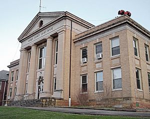
The Gilmer County Courthouse in Glenville
|
||
|
||

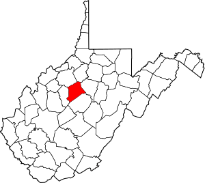
Location within the U.S. state of West Virginia
|
||
 West Virginia's location within the U.S. |
||
| Country | ||
| State | ||
| Founded | February 3, 1845 | |
| Named for | Thomas Walker Gilmer | |
| Seat | Glenville | |
| Largest town | Glenville | |
| Area | ||
| • Total | 340 sq mi (900 km2) | |
| • Land | 339 sq mi (880 km2) | |
| • Water | 1.6 sq mi (4 km2) 0.5%% | |
| Population
(2020)
|
||
| • Total | 7,408 | |
| • Estimate
(2021)
|
7,377 |
|
| • Density | 21.8/sq mi (8.41/km2) | |
| Time zone | UTC−5 (Eastern) | |
| • Summer (DST) | UTC−4 (EDT) | |
| Congressional district | 1st | |
Gilmer County is a county located in the state of West Virginia, United States. In 2020, about 7,408 people lived here. This makes it one of West Virginia's smallest counties by population.
The main town and county seat is Glenville. Gilmer County was created in 1845. It was formed from parts of Lewis and Kanawha Counties. The county is named after Thomas Walker Gilmer. He was the Governor of Virginia from 1840 to 1841. He also served in the United States Congress and was the Secretary of the Navy.
Gilmer County has many fun places to visit and things to do. Cedar Creek State Park is a great spot for camping, fishing, swimming, and hiking. Each June, the West Virginia State Folk Festival takes place here. It celebrates the state's traditional music and crafts.
Glenville State University is also in Gilmer County. It has a modern library and a collection of hand-carved birds. The Gilmer County Recreation Center Complex offers a small golf course. It also has a hall for events and places to stay. The county is home to ten historic landmarks. It also has the Cedar Creek Backway, a scenic route.
Gilmer County has two local newspapers: The Glenville Democrat and The Glenville Pathfinder. The Federal Correctional Institution, Gilmer, a federal prison, is the county's largest employer. As of 2023, Gilmer County has only one permanent traffic light. You can find it in the town of Glenville.
Contents
Geography
Gilmer County covers a total area of about 340 square miles (880 square kilometers). Most of this area, about 339 square miles (878 square kilometers), is land. Only a small part, about 1.6 square miles (4.1 square kilometers), is water.
In the 1800s, West Virginia counties were divided into smaller areas called townships. This was to help with local government. Later, these townships became "magisterial districts." Gilmer County used to have four districts: Centre, De Kalb, Glenville, and Troy. In the 1980s, De Kalb and Troy combined to form De Kalb-Troy District. A new district called City was also created.
Major Roads
You can travel through Gilmer County using several important highways:
 U.S. Highway 33
 U.S. Highway 119
 West Virginia Route 5
 West Virginia Route 18
 West Virginia Route 47
 West Virginia Route 74
 Interstate 79 (This highway passes through but has no exits in the county.)
Neighboring Counties
Gilmer County shares its borders with several other counties:
- Doddridge County (to the north)
- Lewis County (to the east)
- Braxton County (to the south)
- Calhoun County (to the west)
- Ritchie County (to the northwest)
Population Information
| Historical population | |||
|---|---|---|---|
| Census | Pop. | %± | |
| 1850 | 3,475 | — | |
| 1860 | 3,759 | 8.2% | |
| 1870 | 4,338 | 15.4% | |
| 1880 | 7,108 | 63.9% | |
| 1890 | 9,746 | 37.1% | |
| 1900 | 11,762 | 20.7% | |
| 1910 | 11,379 | −3.3% | |
| 1920 | 10,668 | −6.2% | |
| 1930 | 10,641 | −0.3% | |
| 1940 | 12,046 | 13.2% | |
| 1950 | 9,746 | −19.1% | |
| 1960 | 8,050 | −17.4% | |
| 1970 | 7,782 | −3.3% | |
| 1980 | 8,334 | 7.1% | |
| 1990 | 7,669 | −8.0% | |
| 2000 | 7,160 | −6.6% | |
| 2010 | 8,693 | 21.4% | |
| 2020 | 7,408 | −14.8% | |
| 2021 (est.) | 7,377 | −15.1% | |
| U.S. Decennial Census 1790–1960 1900–1990 1990–2000 2010–2020 |
|||
In 2010, there were 8,693 people living in Gilmer County. There were 2,753 households, and 1,806 families. The population density was about 25.7 people per square mile. The average household had 2.34 people, and the average family had 2.83 people. The median age of people in the county was 38.0 years old.
Communities
Towns
Magisterial Districts
- Center
- City
- De Kalb-Troy
- Glenville
Other Communities
These are smaller places that are not officially towns:
See also
 In Spanish: Condado de Gilmer (Virginia Occidental) para niños
 | Percy Lavon Julian |
 | Katherine Johnson |
 | George Washington Carver |
 | Annie Easley |


