Sand Fork, West Virginia facts for kids
Quick facts for kids
Sand Fork, West Virginia
|
|
|---|---|

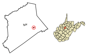
Location of Sand Fork in Gilmer County, West Virginia.
|
|
| Country | United States |
| State | West Virginia |
| County | Gilmer |
| Area | |
| • Total | 0.35 sq mi (0.90 km2) |
| • Land | 0.33 sq mi (0.84 km2) |
| • Water | 0.02 sq mi (0.06 km2) |
| Elevation | 735 ft (224 m) |
| Population
(2020)
|
|
| • Total | 182 |
| • Estimate
(2021)
|
181 |
| • Density | 455.38/sq mi (175.95/km2) |
| Time zone | UTC-5 (Eastern (EST)) |
| • Summer (DST) | UTC-4 (EDT) |
| ZIP code |
26430
|
| Area code(s) | 304 |
| FIPS code | 54-71620 |
| GNIS feature ID | 1546345 |
Sand Fork is a small town in Gilmer County, West Virginia, United States. In 2020, about 182 people lived there. The town is located along the Little Kanawha River. It's also at the mouth of a smaller stream called the Sand Fork.
Contents
History of Sand Fork
Sand Fork was first set up as a town in 1903. Back then, it was called Layopolis. It got its name from William R. Lay. He worked for a company called Eureka Pipe Line Company. This company was involved in the oil fields nearby.
For a long time, the town was known as Layopolis. But its post office was always called Sand Fork. In 1983, the people of the town voted to change the name. That's how Layopolis officially became Sand Fork.
Geography of Sand Fork
Sand Fork is located in West Virginia. Its exact location is 38°54′49″N 80°45′00″W / 38.913684°N 80.749976°W.
The town covers a total area of about 0.90 square kilometers (0.35 square miles). Most of this area is land, about 0.84 square kilometers (0.33 square miles). A small part, about 0.06 square kilometers (0.02 square miles), is water.
Population and People
| Historical population | |||
|---|---|---|---|
| Census | Pop. | %± | |
| 1970 | 252 | — | |
| 1980 | 280 | 11.1% | |
| 1990 | 196 | −30.0% | |
| 2000 | 176 | −10.2% | |
| 2010 | 159 | −9.7% | |
| 2020 | 182 | 14.5% | |
| 2021 (est.) | 181 | 13.8% | |
| U.S. Decennial Census | |||
Population in 2010
According to the census from 2010, there were 159 people living in Sand Fork. These people lived in 60 different homes. The town had about 481.8 people per square mile. There were 68 housing units in total.
Most of the people living in Sand Fork were White (98.1%). A small number (1.9%) were from two or more races.
The average age of people in the town was 35.5 years old. About 29.6% of the residents were under 18 years old. About 15.7% were 65 years old or older. There were more females (56.0%) than males (44.0%) in the town.
Things to See and Do
This small town has several interesting features. You can find an old general store, which is a type of shop. There are also several churches and an elementary school. A number of small businesses operate here too.
Near Sand Fork, there's a starting point for many off-road vehicle (ORV) trails. These trails are on private land, but people can use them freely. The trails are best for smaller vehicles. However, some parts can be used by larger ORVs.
See also
 In Spanish: Sand Fork (Virginia Occidental) para niños
 | Leon Lynch |
 | Milton P. Webster |
 | Ferdinand Smith |

