
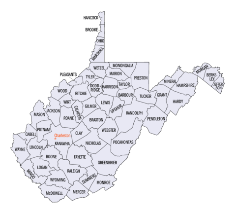
List of counties in West Virginia facts for kids
Quick facts for kids Counties of West Virginia |
|
|---|---|
 |
|
| Location | State of West Virginia |
| Number | 55 |
| Populations | 5,000 (Wirt) – 174,805 (Kanawha) |
| Areas | 83 square miles (210 km2) (Hancock) – 1,040 square miles (2,700 km2) (Randolph) |
| Government | County government |
| Subdivisions | cities, towns, unincorporated communities, census designated place |
The U.S. state of West Virginia has 55 counties. These counties are like smaller regions within the state. They help organize local government and services.
Fifty of these counties existed in 1861, during the American Civil War. These counties decided to separate from Virginia to create the new state of West Virginia. West Virginia officially became a state on June 20, 1863. After this, five more counties were formed from the original ones. These new counties are Grant, Mineral, Lincoln, Summers, and Mingo.
Contents
How West Virginia's Counties Were Formed
Joining the New State
After the Civil War, two eastern counties, Berkeley and Jefferson, did not want to be part of West Virginia. Virginia tried to get them back. However, in 1866, the United States Congress said they belonged to West Virginia. The Supreme Court of the United States agreed in 1871.
Rules for New Counties
The West Virginia Constitution was approved in 1872. It replaced the first state constitution from 1863. Article 9, Section 8, of this constitution explains how new counties can be made.
For a new county to be created, most citizens in that area must vote for it. The new county also needs to be at least 400 square miles (1,036 square kilometers) in size. It must also have a population of at least 6,000 people.
You cannot create a new county if it makes an existing county too small or with too few people. Based on the 2020 census, only three counties could be split: Greenbrier, Kanawha, and Randolph. All other counties are too small or do not have enough people to be divided.
How County Governments Work
Changes in County Government Powers
The first West Virginia constitution (1863) gave counties less power. Most local government tasks were handled by a system of townships, similar to those in New England.
The 1872 constitution changed this. It brought back a system like Virginia's, where each county was run by a county court. This court handled executive, legislative, and judicial jobs.
In 1880, West Virginia changed its constitution again. The county court system was replaced. Now, county government powers are divided among seven elected officials:
- The county commission
- County clerk
- Circuit clerk
- County sheriff
- County assessor
- County prosecuting attorney
- County surveyor of lands
What Counties Do
Counties only have the powers given to them by the state Constitution or state laws. Their jobs include:
- Keeping up the state's roads and other important structures.
- Providing money for libraries.
- Maintaining jails and hospitals.
- Managing waste disposal.
Public Education and Counties
In 1933, public education became a county responsibility. A "county unit plan" was started in May 1933. This plan combined the state's 398 school districts into the current 55 county school systems. This change made public schools more affordable and saved West Virginia a lot of money.
Facts About West Virginia Counties
Randolph County is the largest county by area. It covers 1,040 square miles (2,694 square kilometers). Hancock County is the smallest, at 83 square miles (215 square kilometers).
Kanawha County is the most populated, with 174,805 people in 2023. It also contributed land to create 12 other West Virginia counties. Wirt County has the smallest population, with 5,000 people in 2023.
The oldest county is Hampshire, created in 1754. The newest is Mingo, established in 1895.
Spruce Knob, located in Pendleton County, is the highest point in West Virginia. It is 4,863 feet (1,482 meters) tall.
The United States government uses special numbers called FIPS codes to identify counties. For West Virginia, these five-digit codes start with "54". For example, Barbour County's FIPS code is 54001. Each county's code is in the table below.
List of West Virginia Counties
| County |
FIPS code | County seat | Est. | Origin | Etymology | Population | Area | Map |
|---|---|---|---|---|---|---|---|---|
| Barbour County | 001 | Philippi | 1843 | Harrison, Lewis, and Randolph counties | Philip P. Barbour (1783–1841) United States Speaker of the House (1821–23) |
15,378 | 341 sq mi (883 km2) |
 |
| Berkeley County | 003 | Martinsburg | 1772 | Frederick County (Virginia) | Norborne Berkeley (1717–70) Royal Governor of Virginia (1768–70) |
132,440 | 321 sq mi (831 km2) |
 |
| Boone County | 005 | Madison | 1847 | Cabell, Kanawha, and Logan counties | Daniel Boone (1734–1820) American frontiersman |
20,576 | 503 sq mi (1,303 km2) |
 |
| Braxton County | 007 | Sutton | 1836 | Kanawha, Lewis, and Nicholas counties | Carter Braxton (1736–97) Signer of the Declaration of Independence |
12,162 | 514 sq mi (1,331 km2) |
 |
| Brooke County | 009 | Wellsburg | 1796 | Ohio County | Robert Brooke (1761–1800) Governor of Virginia (1794–96) |
21,373 | 89 sq mi (231 km2) |
 |
| Cabell County | 011 | Huntington | 1809 | Kanawha County | William H. Cabell (1772–1853) Governor of Virginia (1805–08) |
92,082 | 282 sq mi (730 km2) |
 |
| Calhoun County | 013 | Grantsville | 1856 | Gilmer County | John C. Calhoun (1782–1850) United States Vice President (1825–32) |
5,959 | 281 sq mi (728 km2) |
 |
| Clay County | 015 | Clay | 1858 | Braxton and Nicholas counties | Henry Clay (1777–1852) United States Senator Kentucky (1823–25) United States Speaker of the House (1849–52) |
7,783 | 342 sq mi (886 km2) |
 |
| Doddridge County | 017 | West Union | 1845 | Harrison, Lewis, Ritchie, and Tyler counties | Philip Doddridge (1773–1832) United States Congressman (Virginia) (1829–32) |
7,680 | 320 sq mi (829 km2) |
 |
| Fayette County | 019 | Fayetteville | 1831 | Kanawha, Greenbrier, Logan, and Nicholas counties | Marquis de Lafayette (1757–1834) French-born American Revolutionary War General |
39,072 | 664 sq mi (1,720 km2) |
 |
| Gilmer County | 021 | Glenville | 1845 | Kanawha and Lewis counties | Thomas Walker Gilmer (1802–44) United States Secretary of the Navy (1844) Governor of Virginia (1840–41) |
7,254 | 340 sq mi (881 km2) |
 |
| Grant County | 023 | Petersburg | 1866 | Hardy County | Ulysses S. Grant (1822–85) United States President (1869–77) |
10,921 | 477 sq mi (1,235 km2) |
 |
| Greenbrier County | 025 | Lewisburg | 1778 | Montgomery County (Virginia) and Botetourt County (Virginia) | Greenbrier River | 32,149 | 1,021 sq mi (2,644 km2) |
 |
| Hampshire County | 027 | Romney | 1754 | Augusta County (Virginia) and Frederick County (Virginia) | County of Hampshire in England | 23,649 | 642 sq mi (1,663 km2) |
 |
| Hancock County | 029 | New Cumberland | 1848 | Brooke County | John Hancock (1737–93) One of the Signers of the Declaration of Independence Governor of Massachusetts (1780–85) and (1787–93) |
28,145 | 83 sq mi (215 km2) |
 |
| Hardy County | 031 | Moorefield | 1786 | Hampshire County | Samuel Hardy (1758–85) Virginia delegate to the Continental Congress (1783–85) |
14,251 | 583 sq mi (1,510 km2) |
 |
| Harrison County | 033 | Clarksburg | 1784 | Monongalia County | Benjamin Harrison V (1726–91) Governor of Virginia (1781–84) |
64,639 | 416 sq mi (1,077 km2) |
 |
| Jackson County | 035 | Ripley | 1831 | Kanawha, Mason, and Wood counties | Andrew Jackson (1767–1845) United States President (1829–37) |
27,593 | 466 sq mi (1,207 km2) |
 |
| Jefferson County | 037 | Charles Town | 1801 | Berkeley County | Thomas Jefferson (1743–1826) United States President (1801–09) |
59,787 | 210 sq mi (544 km2) |
 |
| Kanawha County | 039 | Charleston | 1789 | Greenbrier and Montgomery County (Virginia) | Kanawha River | 174,805 | 903 sq mi (2,339 km2) |
 |
| Lewis County | 041 | Weston | 1816 | Harrison County | Charles Lewis (1736–74) American Colonel killed at the Battle of Point Pleasant |
16,500 | 389 sq mi (1,008 km2) |
 |
| Lincoln County | 043 | Hamlin | 1867 | Boone, Cabell, Kanawha, and Putnam counties | Abraham Lincoln (1809–65) United States President (1861–65) |
19,701 | 438 sq mi (1,134 km2) |
 |
| Logan County | 045 | Logan | 1824 | Cabell and Kanawha counties, Giles County (Virginia), and Tazewell County (Virginia) | Chief Logan (c. 1723-80) Mingo leader |
30,827 | 454 sq mi (1,176 km2) |
 |
| Marion County | 049 | Fairmont | 1842 | Harrison and Monongalia counties | Francis Marion (1732–95) American Revolutionary War General (1757–82) |
55,807 | 310 sq mi (803 km2) |
 |
| Marshall County | 051 | Moundsville | 1835 | Ohio County | John Marshall (1755–1835) United States Secretary of State (1800–01) Chief Justice of the United States (1801–35) |
29,405 | 307 sq mi (795 km2) |
 |
| Mason County | 053 | Point Pleasant | 1804 | Kanawha County | George Mason (1725–92) United States Constitutional Convention "Father of the Bill of Rights" |
24,765 | 432 sq mi (1,119 km2) |
 |
| McDowell County | 047 | Welch | 1858 | Tazewell County (Virginia) | James McDowell (1795–1851) Governor of Virginia (1843–46) |
17,439 | 535 sq mi (1,386 km2) |
 |
| Mercer County | 055 | Princeton | 1837 | Giles County (Virginia) and Tazewell County (Virginia) | Hugh Mercer (1726–77) American Revolutionary War General (1775–76) |
58,057 | 420 sq mi (1,088 km2) |
 |
| Mineral County | 057 | Keyser | 1866 | Hampshire County | abundant mineral resources | 26,867 | 328 sq mi (850 km2) |
 |
| Mingo County | 059 | Williamson | 1895 | Logan County | Mingo Native Americans | 22,023 | 423 sq mi (1,096 km2) |
 |
| Monongalia County | 061 | Morgantown | 1776 | Augusta County (Virginia) | Latin derivation for Monongahela River | 107,718 | 361 sq mi (935 km2) |
 |
| Monroe County | 063 | Union | 1799 | Greenbrier County | James Monroe (1758–1831) United States Senator (Virginia) (1790–94) Governor of Virginia (1799–1802) and (1811) United States President (1817–25) |
12,382 | 473 sq mi (1,225 km2) |
 |
| Morgan County | 065 | Berkeley Springs | 1820 | Berkeley and Hampshire counties | Daniel Morgan (1736–1802) United States Congressman (Virginia) (1797–99) |
17,649 | 229 sq mi (593 km2) |
 |
| Nicholas County | 067 | Summersville | 1818 | Greenbrier, Kanawha, and Randolph counties | Wilson Cary Nicholas (1761–1820) United States Senator (Virginia) (1799–1804) Governor of Virginia (1814–16) |
24,169 | 649 sq mi (1,681 km2) |
 |
| Ohio County | 069 | Wheeling | 1776 | Augusta County (Virginia) | Ohio River | 41,194 | 106 sq mi (275 km2) |
 |
| Pendleton County | 071 | Franklin | 1788 | Augusta County (Virginia), Rockingham County (Virginia), and Hardy | Edmund Pendleton (1721–1803) First Continental Congress (1774) |
6,029 | 698 sq mi (1,808 km2) |
 |
| Pleasants County | 073 | Saint Marys | 1851 | Ritchie, Tyler, and Wood counties | James Pleasants, Jr. (1769–1836) United States Senator (Virginia) (1819–22) Governor of Virginia (1822–25) |
7,428 | 131 sq mi (339 km2) |
 |
| Pocahontas County | 075 | Marlinton | 1821 | Bath County (Virginia), Pendleton, and Randolph | Pocahontas (c. 1595–1617) Powhatan Native American slave of early English settlers |
7,765 | 940 sq mi (2,435 km2) |
 |
| Preston County | 077 | Kingwood | 1818 | Monongalia County | James Patton Preston (1774–1843) Governor of Virginia (1816–19) |
34,099 | 648 sq mi (1,678 km2) |
 |
| Putnam County | 079 | Winfield | 1848 | Cabell, Kanawha, and Mason counties | Israel Putnam (1718–90) American Revolutionary War General |
56,962 | 346 sq mi (896 km2) |
 |
| Raleigh County | 081 | Beckley | 1850 | Fayette County | Sir Walter Raleigh (1554–1618) English explorer and poet |
72,356 | 607 sq mi (1,572 km2) |
 |
| Randolph County | 083 | Elkins | 1787 | Harrison County | Edmund Jennings Randolph (1753–1813) Governor of Virginia (1786–88) First United States Attorney General (1789–94) |
27,350 | 1,040 sq mi (2,694 km2) |
 |
| Ritchie County | 085 | Harrisville | 1843 | Harrison, Lewis, and Wood counties | Thomas Ritchie (1778–1854) nationally influential Virginia newspaper publisher |
8,167 | 454 sq mi (1,176 km2) |
 |
| Roane County | 087 | Spencer | 1856 | Gilmer, Jackson, and Kanawha counties | Spencer Roane (1762–1822) Virginia Supreme Court Justice (1794–1822) |
13,743 | 484 sq mi (1,254 km2) |
 |
| Summers County | 089 | Hinton | 1871 | Fayette, Greenbrier, Mercer, and Monroe counties | George W. Summers (1804–68) United States Congressman (Virginia) (1843) |
11,581 | 361 sq mi (935 km2) |
 |
| Taylor County | 091 | Grafton | 1844 | Barbour, Harrison, Marion counties | John Taylor of Caroline (1753–1824) United States Senator (Virginia) (1792–94) and (1803) and (1822–24) |
16,388 | 173 sq mi (448 km2) |
 |
| Tucker County | 093 | Parsons | 1856 | Randolph County | Henry St. George Tucker (1780–1848) United States Congressman (Virginia) (1815–19) Virginia Supreme Court (1831–41) |
6,604 | 419 sq mi (1,085 km2) |
 |
| Tyler County | 095 | Middlebourne | 1814 | Ohio County | John Tyler, Sr. (1747–1813) Governor of Virginia (1808–11) |
7,919 | 258 sq mi (668 km2) |
 |
| Upshur County | 097 | Buckhannon | 1851 | Barbour, Lewis, and Randolph counties | Abel Parker Upshur (1790–1844) United States Secretary of the Navy (1841–43) United States Secretary of State (1843–44) |
23,529 | 355 sq mi (919 km2) |
 |
| Wayne County | 099 | Wayne | 1842 | Cabell County | "Mad" Anthony Wayne Major General (1745–96) American Revolutionary War (1775–83) and (1792–96) United States Congressman Georgia (1791) |
37,686 | 506 sq mi (1,311 km2) |
 |
| Webster County | 101 | Webster Springs | 1860 | Braxton, Nicholas, and Randolph counties | Daniel Webster (1782–1852) United States Senator Massachusetts (1827–41) and (1845–50) United States Secretary of State (1841–53) and (1850–52) |
8,045 | 556 sq mi (1,440 km2) |
 |
| Wetzel County | 103 | New Martinsville | 1846 | Tyler County | Lewis Wetzel (1763–1808) noted frontiersman |
13,890 | 359 sq mi (930 km2) |
 |
| Wirt County | 105 | Elizabeth | 1848 | Jackson and Wood counties | William Wirt (1772–1834) United States Attorney General (1817–29) |
5,000 | 233 sq mi (603 km2) |
 |
| Wood County | 107 | Parkersburg | 1798 | Harrison County | James Wood (1741–1813) Governor of Virginia (1796–99) |
83,052 | 367 sq mi (951 km2) |
 |
| Wyoming County | 109 | Pineville | 1850 | Logan County | derived from Lenape Native American term for "wide plain" | 20,277 | 501 sq mi (1,298 km2) |
 |
See also
 In Spanish: Anexo:Condados de Virginia Occidental para niños
- List of governors of West Virginia
- List of National Historic Landmarks in West Virginia
- List of West Virginia counties by socioeconomic factors
