Webster County, West Virginia facts for kids
Quick facts for kids
Webster County
|
|
|---|---|

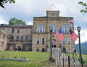
Webster County Courthouse
in Webster Springs, 2007 |
|

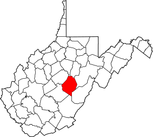
Location within the U.S. state of West Virginia
|
|
 West Virginia's location within the U.S. |
|
| Country | |
| State | |
| Founded | January 10, 1860 |
| Named for | Daniel Webster |
| Seat | Webster Springs |
| Largest town | Webster Springs |
| Area | |
| • Total | 556 sq mi (1,440 km2) |
| • Land | 553 sq mi (1,430 km2) |
| • Water | 2.8 sq mi (7 km2) 0.5%% |
| Population
(2020)
|
|
| • Total | 8,378 |
| • Estimate
(2021)
|
8,249 |
| • Density | 15.068/sq mi (5.818/km2) |
| Time zone | UTC−5 (Eastern) |
| • Summer (DST) | UTC−4 (EDT) |
| Congressional district | 1st |
Webster County is a county located in the state of West Virginia, United States. In 2020, the population of the county was 8,378 people. The main town and county seat is Webster Springs. This county was created in 1860. It was named after Daniel Webster, a famous American statesman.
Contents
Discovering Webster County's Past
Webster County was formed from parts of three other counties: Nicholas, Braxton, and Randolph. These areas were all part of Virginia at the time. The idea to create this new county started in 1851. The official approval came in 1860 from the Virginia government.
On June 20, 1863, Webster County became part of the new state of West Virginia. When West Virginia was formed, counties were divided into smaller areas called civil townships. The goal was to help local governments work better. However, this system was not practical in rural areas. So, in 1872, these townships became "magisterial districts."
Original Districts of Webster County
Webster County first had three magisterial districts:
- Fork Lick
- Glade
- Holly
A fourth district, Hacker Valley, was added in 1876. It was created from a part of Holly District. These four districts stayed mostly the same for a long time.
Changes to Districts in the 1990s
In the 1990s, the districts were changed. The four older districts were combined into three new ones:
- Central
- Northern
- Southern
Exploring Webster County's Geography
Webster County covers a total area of about 556 square miles (1,440 square kilometers). Most of this area, about 553 square miles (1,432 square kilometers), is land. The remaining 2.8 square miles (7.3 square kilometers) is water. This means about 0.5% of the county is covered by water.
Main Roads in Webster County
These are the most important highways that run through Webster County:
Neighboring Counties
Webster County shares its borders with several other counties:
- Lewis County (to the north)
- Upshur County (to the north)
- Randolph County (to the east)
- Pocahontas County (to the southeast)
- Greenbrier County (to the south)
- Nicholas County (to the southwest)
- Braxton County (to the west)
Protected Natural Areas
Part of the Monongahela National Forest is located within Webster County. This is a large protected area known for its beautiful nature.
Rivers and Streams
- Cougar Fork is one of the streams found in the county.
Understanding Webster County's Population
| Historical population | |||
|---|---|---|---|
| Census | Pop. | %± | |
| 1860 | 1,555 | — | |
| 1870 | 1,730 | 11.3% | |
| 1880 | 3,207 | 85.4% | |
| 1890 | 4,783 | 49.1% | |
| 1900 | 8,862 | 85.3% | |
| 1910 | 9,680 | 9.2% | |
| 1920 | 11,562 | 19.4% | |
| 1930 | 14,216 | 23.0% | |
| 1940 | 18,080 | 27.2% | |
| 1950 | 17,888 | −1.1% | |
| 1960 | 13,719 | −23.3% | |
| 1970 | 9,809 | −28.5% | |
| 1980 | 12,245 | 24.8% | |
| 1990 | 10,729 | −12.4% | |
| 2000 | 9,719 | −9.4% | |
| 2010 | 9,154 | −5.8% | |
| 2020 | 8,378 | −8.5% | |
| 2021 (est.) | 8,249 | −9.9% | |
| U.S. Decennial Census 1790–1960 1900–1990 1990–2000 2010–2020 |
|||
The population of Webster County has changed over many years. In 2010, there were 9,154 people living in the county. The population density was about 16.5 people per square mile. This means the county is not very crowded.
Most of the people living in Webster County are white (98.6%). A small number of people are from other racial backgrounds. About 0.5% of the population identified as Hispanic or Latino. Many residents have ancestors from Ireland, Germany, and England.
The average age of people in Webster County in 2010 was 44.1 years old. About 30.1% of households had children under 18 living with them.
Towns and Communities in Webster County
Webster County has several towns and smaller communities.
Main Towns
- Camden-on-Gauley
- Cowen
- Webster Springs (This is the county seat, also known as the Town of Addison)
Current Magisterial Districts
These are the three districts used today:
- Central
- Northern
- Southern
Historic Magisterial Districts
These were the original districts:
- Fork Lick
- Glade
- Hacker Valley
- Holly
Census-Designated Places
These are areas that are like towns but are not officially incorporated:
Other Communities (Unincorporated)
These are smaller communities that do not have their own local government:
Famous Person from Webster County
- Josh Stewart is an actor who comes from Webster County.
See also
 In Spanish: Condado de Webster (Virginia Occidental) para niños
 | Ernest Everett Just |
 | Mary Jackson |
 | Emmett Chappelle |
 | Marie Maynard Daly |

