Nicholas County, West Virginia facts for kids
Quick facts for kids
Nicholas County
|
||
|---|---|---|

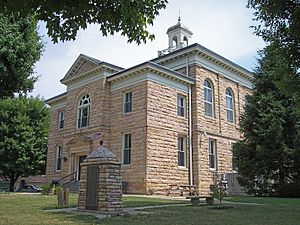
The Nicholas County Courthouse in Summersville in 2007
|
||
|
||

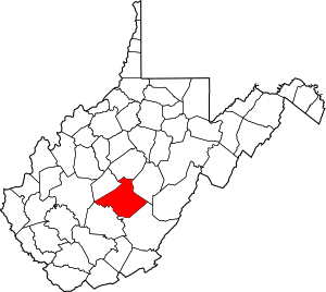
Location within the U.S. state of West Virginia
|
||
 West Virginia's location within the U.S. |
||
| Country | ||
| State | ||
| Founded | January 30, 1818 | |
| Named for | Wilson Cary Nicholas | |
| Seat | Summersville | |
| Largest city | Summersville | |
| Area | ||
| • Total | 654 sq mi (1,690 km2) | |
| • Land | 647 sq mi (1,680 km2) | |
| • Water | 7.6 sq mi (20 km2) 1.2%% | |
| Population
(2020)
|
||
| • Total | 24,604 | |
| • Estimate
(2021)
|
24,300 |
|
| • Density | 37.621/sq mi (14.525/km2) | |
| Time zone | UTC−5 (Eastern) | |
| • Summer (DST) | UTC−4 (EDT) | |
| Congressional district | 1st | |

Nicholas County is a special area called a county in the middle of West Virginia. Think of it like a big neighborhood with its own local government. In 2020, about 24,604 people lived here. The main town and where the county government is located is Summersville. Nicholas County was officially created in 1818. It was named after Wilson Cary Nicholas, who was a governor of Virginia a long time ago.
Contents
Exploring Nicholas County's Land
Nicholas County covers a total area of about 654 square miles. Most of this area, about 647 square miles, is land. The rest, about 7.6 square miles, is water. That's about 1.2% of the total area.
Back in 1863, West Virginia divided its counties into smaller parts called townships. This was to help local areas manage themselves better. But it was hard to do in places with few people. So, in 1872, these townships became "magisterial districts." Nicholas County was first split into six districts. These were Grant, Jefferson, Kentucky, Mumble-the-peg, Summersville, and Wilderness. In 1873, Mumble-the-peg changed its name to Hamilton District. Later, in the 1880s, a seventh district called Beaver was added.
Main Roads in Nicholas County
These are the most important roads that help people travel through Nicholas County:
 U.S. Highway 19
 West Virginia Route 20
 West Virginia Route 39
 West Virginia Route 41
 West Virginia Route 55
Historic Battlefields
Nicholas County is home to some historic battlefields:
- Carnifex Ferry Battlefield
- Keslers Cross Lanes
Neighboring Counties
Nicholas County shares its borders with several other counties:
- Braxton County (to the north)
- Webster County (to the northeast)
- Greenbrier County (to the southeast)
- Fayette County (to the southwest)
- Clay County (to the northwest)
- Kanawha County (to the west)
Protected Natural Areas
Parts of these beautiful natural areas are found in Nicholas County:
- Gauley River National Recreation Area
- Monongahela National Forest
Who Lives in Nicholas County?
| Historical population | |||
|---|---|---|---|
| Census | Pop. | %± | |
| 1820 | 1,853 | — | |
| 1830 | 3,346 | 80.6% | |
| 1840 | 2,515 | −24.8% | |
| 1850 | 3,963 | 57.6% | |
| 1860 | 4,627 | 16.8% | |
| 1870 | 4,458 | −3.7% | |
| 1880 | 7,223 | 62.0% | |
| 1890 | 9,309 | 28.9% | |
| 1900 | 11,403 | 22.5% | |
| 1910 | 17,699 | 55.2% | |
| 1920 | 20,717 | 17.1% | |
| 1930 | 20,686 | −0.1% | |
| 1940 | 24,070 | 16.4% | |
| 1950 | 27,696 | 15.1% | |
| 1960 | 25,414 | −8.2% | |
| 1970 | 22,552 | −11.3% | |
| 1980 | 28,126 | 24.7% | |
| 1990 | 26,775 | −4.8% | |
| 2000 | 26,562 | −0.8% | |
| 2010 | 26,233 | −1.2% | |
| 2020 | 24,604 | −6.2% | |
| 2021 (est.) | 24,300 | −7.4% | |
| U.S. Decennial Census 1790–1960 1900–1990 1990–2000 2010–2020 |
|||
A Look at the 2010 Population
In 2010, there were 26,233 people living in Nicholas County. These people lived in 10,938 homes, and 7,591 of these were families. The county had about 40.6 people per square mile. Most people (98.4%) were white. A small number of people were Asian, American Indian, or Black. About 0.6% of the population was of Hispanic or Latino background.
Many families (28.8%) had children under 18 living with them. More than half of the homes (53.8%) were married couples. The average age of people in the county was about 43.3 years old.
Towns and Areas in Nicholas County
Cities
- Richwood
- Summersville (This is the main town and county seat)
Magisterial Districts
- Beaver
- Grant
- Hamilton
- Jefferson
- Kentucky
- Summersville
- Wilderness
Census-Designated Places (CDPs)
These are areas that are like towns but are not officially incorporated as cities.
Unincorporated Communities
These are smaller communities that are not officially part of a city or CDP.
See also
 In Spanish: Condado de Nicholas (Virginia Occidental) para niños
 | Anna J. Cooper |
 | Mary McLeod Bethune |
 | Lillie Mae Bradford |


