Richwood, West Virginia facts for kids
Quick facts for kids
Richwood, West Virginia
|
|||||
|---|---|---|---|---|---|
 |
|||||
|
|||||
| Nickname(s):
"The Ramp Capital of the World,"
"The Gateway to the Monongahela National Forest" |
|||||
| Motto(s):
The City Merry on the Banks of the Cherry
|
|||||
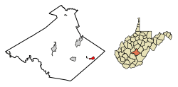
Location of Richwood in Nicholas County, West Virginia.
|
|||||
| Country | United States | ||||
| State | West Virginia | ||||
| County | Nicholas | ||||
| Area | |||||
| • Total | 1.67 sq mi (4.32 km2) | ||||
| • Land | 1.61 sq mi (4.17 km2) | ||||
| • Water | 0.06 sq mi (0.15 km2) 3.59% | ||||
| Elevation | 2,205 ft (672 m) | ||||
| Population
(2020)
|
|||||
| • Total | 1,661 | ||||
| • Estimate
(2021)
|
1,637 | ||||
| • Density | 1,152.17/sq mi (444.95/km2) | ||||
| Time zone | UTC-5 (EST) | ||||
| • Summer (DST) | UTC-4 (EDT) | ||||
| ZIP code |
26261
|
||||
| Area code(s) | 304, 681 | ||||
| FIPS code | 54-68116 | ||||
| GNIS feature ID | 1555475 | ||||
| Website | cityofrichwoodwv.com | ||||
Richwood is a city located in Nicholas County, West Virginia, United States. In 2020, about 1,661 people lived there.
For many years, Richwood was a busy town known for its coal mining and lumber industries. It has a special history, including a group called the Cherry River Navy. This group worked to bring attention to important local issues. Richwood is also famous as the "Ramp Capital of the World." Every April, the city hosts a big festival that brings visitors from all over.
Contents
Richwood's History
People have lived near the Cherry River since the late 1700s. For a long time, it was a quiet area with mostly farms. This changed in 1898 when a railroad was built here. The area was then known as Cherry Tree Bottoms.
In 1901, the town became official and was named Richwood. This name came from the many hardwood forests nearby. Soon, Richwood had a large sawmill and the world's biggest clothespin factory!
Growth and Change in Richwood
Richwood was once home to many big businesses. Besides the sawmill and clothespin factory, other factories made wood products like axe handles and paper. Coal mining also became very important before the Great Depression. Banks also did well as large companies invested in the city.
However, when the big factories closed or moved, many people left Richwood. The coal industry also slowed down, and most local coal mines closed. This caused the town to face tough times.
Today, Richwood is working to become a center for artisan crafts and technology. The Downtown Richwood Historic District was added to the National Register of Historic Places in 2001. This means its historic buildings are protected.
Richwood is the home of the Cherry River Navy. This group was started by John Teets, A.B. Campbell, and Lee Reese. They wanted to help build a missing road link between Richwood and Marlinton. This road, part of West Virginia Route 39, has since been built.
The 2016 Flood
On June 23, 2016, a very bad flood hit parts of West Virginia. Richwood was one of the towns most affected. The flood caused a lot of damage to roads and buildings. Richwood High School and Richwood Middle School were so damaged they had to be closed.
Richwood's Geography
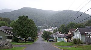
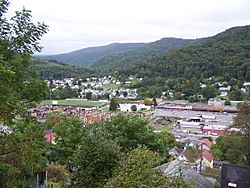
Richwood is located at 38°13′25″N 80°32′12″W / 38.22361°N 80.53667°W. The Cherry River starts in Richwood where its north and south forks join together. Some parts of the city are flat along the river valley. Other neighborhoods are built on the steep hillsides nearby.
The United States Census Bureau says Richwood covers about 1.67 square miles (4.32 square kilometers). Most of this area is land, with a small part being water.
Richwood's Climate
The climate in Richwood has mild changes between high and low temperatures. It also gets enough rain all year. According to the Köppen Climate Classification system, Richwood has a marine west coast climate. This means it has cool, but not freezing, winters and warm, but not hot, summers.
| Climate data for Richwood 1SSE, West Virginia, 1991–2020 normals, 1985-2020 extremes: 3090ft (942m) | |||||||||||||
|---|---|---|---|---|---|---|---|---|---|---|---|---|---|
| Month | Jan | Feb | Mar | Apr | May | Jun | Jul | Aug | Sep | Oct | Nov | Dec | Year |
| Record high °F (°C) | 67 (19) |
71 (22) |
80 (27) |
84 (29) |
87 (31) |
89 (32) |
94 (34) |
93 (34) |
90 (32) |
84 (29) |
81 (27) |
74 (23) |
94 (34) |
| Mean maximum °F (°C) | 60.6 (15.9) |
62.0 (16.7) |
69.8 (21.0) |
78.9 (26.1) |
80.9 (27.2) |
83.3 (28.5) |
84.2 (29.0) |
84.6 (29.2) |
82.5 (28.1) |
77.0 (25.0) |
70.1 (21.2) |
61.8 (16.6) |
86.2 (30.1) |
| Mean daily maximum °F (°C) | 37.6 (3.1) |
40.6 (4.8) |
48.4 (9.1) |
60.1 (15.6) |
68.4 (20.2) |
74.2 (23.4) |
77.7 (25.4) |
76.7 (24.8) |
72.1 (22.3) |
62.6 (17.0) |
51.2 (10.7) |
42.0 (5.6) |
59.3 (15.2) |
| Daily mean °F (°C) | 28.7 (−1.8) |
31.1 (−0.5) |
38.8 (3.8) |
49.6 (9.8) |
58.3 (14.6) |
65.0 (18.3) |
68.7 (20.4) |
67.7 (19.8) |
62.5 (16.9) |
52.6 (11.4) |
42.0 (5.6) |
33.6 (0.9) |
49.9 (9.9) |
| Mean daily minimum °F (°C) | 19.9 (−6.7) |
21.7 (−5.7) |
29.1 (−1.6) |
39.2 (4.0) |
48.2 (9.0) |
55.7 (13.2) |
59.8 (15.4) |
58.8 (14.9) |
52.9 (11.6) |
42.7 (5.9) |
32.7 (0.4) |
25.1 (−3.8) |
40.5 (4.7) |
| Mean minimum °F (°C) | −0.9 (−18.3) |
2.2 (−16.6) |
10.2 (−12.1) |
21.3 (−5.9) |
33.4 (0.8) |
43.5 (6.4) |
49.7 (9.8) |
49.5 (9.7) |
37.8 (3.2) |
26.7 (−2.9) |
15.2 (−9.3) |
5.5 (−14.7) |
−4.7 (−20.4) |
| Record low °F (°C) | −24 (−31) |
−12 (−24) |
−3 (−19) |
13 (−11) |
25 (−4) |
34 (1) |
38 (3) |
35 (2) |
29 (−2) |
19 (−7) |
3 (−16) |
−16 (−27) |
−24 (−31) |
| Average precipitation inches (mm) | 4.32 (110) |
3.95 (100) |
5.29 (134) |
4.77 (121) |
5.83 (148) |
5.16 (131) |
5.99 (152) |
4.38 (111) |
4.17 (106) |
3.57 (91) |
3.87 (98) |
4.54 (115) |
55.84 (1,417) |
| Average snowfall inches (cm) | 26.10 (66.3) |
21.90 (55.6) |
16.00 (40.6) |
5.30 (13.5) |
0.00 (0.00) |
0.00 (0.00) |
0.00 (0.00) |
0.00 (0.00) |
0.00 (0.00) |
1.10 (2.8) |
7.50 (19.1) |
22.10 (56.1) |
100 (254) |
| Source 1: NOAA | |||||||||||||
| Source 2: XMACIS (temp records & monthly max/mins) | |||||||||||||
Richwood's Population
| Historical population | |||
|---|---|---|---|
| Census | Pop. | %± | |
| 1910 | 3,061 | — | |
| 1920 | 4,331 | 41.5% | |
| 1930 | 5,720 | 32.1% | |
| 1940 | 5,051 | −11.7% | |
| 1950 | 5,321 | 5.3% | |
| 1960 | 4,110 | −22.8% | |
| 1970 | 3,717 | −9.6% | |
| 1980 | 3,568 | −4.0% | |
| 1990 | 2,808 | −21.3% | |
| 2000 | 2,477 | −11.8% | |
| 2010 | 2,051 | −17.2% | |
| 2020 | 1,661 | −19.0% | |
| 2021 (est.) | 1,637 | −20.2% | |
| U.S. Decennial Census | |||
People in Richwood (2010 Census)
In 2010, there were 2,051 people living in Richwood. They lived in 889 households, and 543 of these were families. The city had about 1,274 people per square mile.
Most people (97.1%) were White. A small number were African American (0.2%) or Native American (0.4%). About 2.2% of people were of two or more races. Hispanic or Latino people made up 0.7% of the population.
About 24.6% of households had children under 18. Many households (40.0%) were married couples. Some households were led by a female (15.2%) or male (5.8%) without a spouse. About 38.9% of households were not families.
The average age in Richwood was 49 years old. About 18.9% of residents were under 18. About 24.7% were 65 or older. The city had slightly more females (52.8%) than males (47.2%).
Richwood's Economy
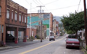
For much of the 20th century, Richwood was the main business center for Nicholas County. However, in the last 25 years, Summersville has become the main shopping and business area. This happened because U.S. Route 19 was made into a four-lane highway, and businesses grew along it.
Still, Richwood remains an important center for eastern Nicholas County. It is the only official city in that area. The city has a small shopping area that includes a Dollar General store.
Efforts have been made to attract visitors to Richwood. People come to enjoy the beautiful nature of the nearby Monongahela National Forest. The mayor has welcomed visitors and encouraged craftspeople to start businesses there.
Richwood also has a small airport called Richwood Municipal Airport. It is located in the nearby community of New Hope. Like many older industrial towns, Richwood has faced some economic challenges.
Fun Places to Visit in Richwood
Richwood is in a mountain setting, very close to the Monongahela National Forest. This means there are many places for outdoor fun!
- Rivers: Three rivers that flow into the Gauley River are found here: the Williams River, Cranberry River, and Cherry River. They are all wild rivers within the forest.
- Scenic Drives: A beautiful highway and visitor center are located near WV 39 and WV 150. This area is close to the Cranberry Glades Botanical Area and the Cranberry Wilderness.
- Cranberry Glades: The Cranberry Glades Botanical Area is a unique place. It's the southernmost Canadian-style bog in the world!
- Summit Lake: Summit Lake is the only place nearby for calm water activities like paddling.
- Golf: Richwood is also home to Cherry Hill Country Club, a nine-hole golf course on Hinkle Mountain.
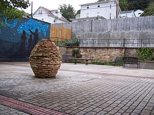
- Sculpture Garden: The Sterling Spencer Memorial Sculpture Garden is a nice park named after a local wood sculptor.
Education in Richwood
Three schools serve students in Richwood. They are managed by the Nicholas County Board of Education:
- Cherry River Elementary
- Richwood Middle School
- Richwood High School
In 2005, the girls' high school softball team won the school's first state championship in any sport!
After the flood on June 23, 2016, Richwood High School and Richwood Middle School had to move temporarily. The school board plans to fix up the Cherry River Elementary site to hold all three of Richwood's schools.
Healthcare in Richwood
Camden Family Health is the main healthcare provider in Richwood. It has a clinic with doctors, nurse practitioners, and registered nurses. For emergencies and hospital care, Summersville Regional Medical Center is the closest option.
Richwood used to have two hospitals. McClung Hospital was open during the city's busy years in the early 1900s. Richwood Area Community Hospital, also known as Sacred Heart Hospital, operated from 1954 until 2008. It closed because of financial problems.
Emergency Services
Richwood has several groups that help keep people safe:
- Fire and Rescue: The Richwood Volunteer Fire Department provides fire and rescue services. They have a central station in town and serve Richwood and nearby areas.
- Police: The Richwood Police Department is the city's main police force. They work from the municipal building. The Nicholas County Sheriff's Department and West Virginia State Police also help when needed.
- Ambulance: Redi-Care Ambulance provides emergency medical services. They are a private company with a station in the east end of town. They usually have an advanced life support (ALS) unit and a basic life support (BLS) unit ready.
Transportation
The main road in Richwood is a two-lane highway that carries West Virginia Routes 39 and 55. These highways connect Richwood to U.S. Route 19 to the west and U.S. Route 219 to the east.
The road from Marlinton to Richwood through the Monongahela National Forest was built thanks to the Cherry River Navy. This road reduced a three-hour drive to about 45 minutes. It is now considered one of the most scenic drives in West Virginia and leads to many National Forest recreation spots.
In the early days of Richwood, the railroad was very important. Trains carried wood, coal, and people in and out of the town every day. Over time, train traffic decreased. By the early 1980s, roads had completely replaced trains for transportation. The train tracks were removed, and the old railroad path was turned into a gravel rail-trail for hiking and bicycling.
Famous People from Richwood
- Michael Barrett: A basketball player who won an Olympic gold medal in 1968.
- Peter Brunette: A film critic and historian.
- Jim Comstock: An editor for local newspapers like The West Virginia Hillbilly.
- Wayland Dean: A professional baseball player.
- Nancy Douglas: A spy during the Civil War.
- Marian McQuade: The person who started National Grandparents Day.
- Marian McQuade: Also in the Richwood High School Hall of Fame.
See also
 In Spanish: Richwood (Virginia Occidental) para niños
 | Toni Morrison |
 | Barack Obama |
 | Martin Luther King Jr. |
 | Ralph Bunche |


