
Marlinton, West Virginia facts for kids
Quick facts for kids
Marlinton, West Virginia
|
|||
|---|---|---|---|

Historic Depot and the Greenbrier River Trail in Marlinton.
|
|||
|
|||

Location of Marlinton in Pocahontas County, West Virginia.
|
|||
| Country | United States | ||
| State | West Virginia | ||
| County | Pocahontas | ||
| Area | |||
| • Total | 2.44 sq mi (6.33 km2) | ||
| • Land | 2.35 sq mi (6.09 km2) | ||
| • Water | 0.09 sq mi (0.24 km2) | ||
| Elevation | 2,126 ft (648 m) | ||
| Population
(2020)
|
|||
| • Total | 998 | ||
| • Estimate
(2021)
|
982 | ||
| • Density | 408.76/sq mi (157.80/km2) | ||
| Time zone | UTC-5 (Eastern (EST)) | ||
| • Summer (DST) | UTC-4 (EDT) | ||
| ZIP code |
24954
|
||
| Area code(s) | 304 | ||
| FIPS code | 54-51676 | ||
| GNIS feature ID | 1552003 | ||
| Website | https://townofmarlintonwv.com/ | ||


Marlinton is a small town in West Virginia, United States. It's the main town, or county seat, of Pocahontas County. In 2020, about 998 people lived there. Marlinton is located right next to the beautiful Greenbrier River and is known for its amazing natural scenery.
Contents
Marlinton's Early Days
Marlinton got its name from Jacob Marlin. In 1749, Jacob Marlin and Stephen Sewell were the first non-native settlers to live west of the Allegheny Mountains in the Greenbrier Valley. They built a cabin in the area that is now Marlinton. After some disagreements, Sewell moved into a nearby hollowed-out sycamore tree.
In 1751, a surveyor named John Lewis found them. Sewell later settled near what is now Rainelle.
Historic Places in Marlinton
Marlinton is home to several important historic buildings. These places are listed on the National Register of Historic Places, which means they are special and protected. They include:
- The Frank and Anna Hunter House
- The IOOF Lodge Building
- The Marlinton Chesapeake and Ohio Railroad Station
- The Marlinton Opera House
- The Pocahontas County Courthouse and Jail
- The Pocahontas Times Print Shop
Close to Marlinton, you can also find Droop Mountain Battlefield and New Deal Resources in Watoga State Park Historic District. These sites also have important history.
Internet Access Challenges
Because Marlinton is in a rural area, and close to the United States National Radio Quiet Zone, getting fast internet has been a challenge. The Radio Quiet Zone is a special area where radio signals are limited. This is to protect sensitive radio telescopes nearby.
However, a ski resort called Snowshoe Mountain, which is also nearby, found a solution. They built a special internet system. This system provides fast internet, WiFi, and cell phone service without bothering the radio telescopes.
Marlinton's Geography
Marlinton covers about 2.53 square miles (6.55 square kilometers). Most of this area is land, with a small part being water. The town is located in the southwest part of the United States National Radio Quiet Zone. This zone helps protect important scientific instruments from radio interference.
Marlinton's Climate
Marlinton has a climate where the temperatures don't change too much between hot and cold. It also gets enough rain all year long. According to the Köppen Climate Classification system, Marlinton has a humid continental climate. This type of climate is often called "Dfb" on climate maps.
| Climate data for Marlinton, West Virginia, 1991–2020 normals, 1893-2020 extremes: 2150ft (655m) | |||||||||||||
|---|---|---|---|---|---|---|---|---|---|---|---|---|---|
| Month | Jan | Feb | Mar | Apr | May | Jun | Jul | Aug | Sep | Oct | Nov | Dec | Year |
| Record high °F (°C) | 76 (24) |
79 (26) |
86 (30) |
92 (33) |
97 (36) |
100 (38) |
97 (36) |
98 (37) |
92 (33) |
90 (32) |
82 (28) |
70 (21) |
100 (38) |
| Mean maximum °F (°C) | 57.5 (14.2) |
60.6 (15.9) |
68.8 (20.4) |
78.4 (25.8) |
82.0 (27.8) |
84.1 (28.9) |
85.9 (29.9) |
84.8 (29.3) |
82.4 (28.0) |
75.8 (24.3) |
68.4 (20.2) |
58.2 (14.6) |
85.7 (29.8) |
| Mean daily maximum °F (°C) | 36.3 (2.4) |
40.4 (4.7) |
48.7 (9.3) |
60.3 (15.7) |
68.3 (20.2) |
75.0 (23.9) |
78.4 (25.8) |
77.1 (25.1) |
72.0 (22.2) |
61.9 (16.6) |
50.2 (10.1) |
39.8 (4.3) |
59.0 (15.0) |
| Daily mean °F (°C) | 26.3 (−3.2) |
29.4 (−1.4) |
36.4 (2.4) |
46.7 (8.2) |
55.6 (13.1) |
63.2 (17.3) |
67.0 (19.4) |
66.0 (18.9) |
60.2 (15.7) |
48.7 (9.3) |
37.7 (3.2) |
29.7 (−1.3) |
47.2 (8.5) |
| Mean daily minimum °F (°C) | 16.2 (−8.8) |
18.4 (−7.6) |
24.1 (−4.4) |
33.0 (0.6) |
42.9 (6.1) |
51.4 (10.8) |
55.7 (13.2) |
54.8 (12.7) |
48.3 (9.1) |
35.4 (1.9) |
25.2 (−3.8) |
19.6 (−6.9) |
35.4 (1.9) |
| Mean minimum °F (°C) | −3.2 (−19.6) |
0.6 (−17.4) |
8.4 (−13.1) |
20.1 (−6.6) |
29.0 (−1.7) |
38.9 (3.8) |
46.2 (7.9) |
45.5 (7.5) |
34.6 (1.4) |
20.8 (−6.2) |
12.5 (−10.8) |
4.6 (−15.2) |
−5.6 (−20.9) |
| Record low °F (°C) | −27 (−33) |
−23 (−31) |
−5 (−21) |
4 (−16) |
20 (−7) |
30 (−1) |
36 (2) |
34 (1) |
24 (−4) |
8 (−13) |
−4 (−20) |
−24 (−31) |
−27 (−33) |
| Average precipitation inches (mm) | 3.57 (91) |
3.17 (81) |
4.11 (104) |
3.95 (100) |
4.82 (122) |
3.85 (98) |
4.38 (111) |
3.88 (99) |
3.49 (89) |
2.89 (73) |
3.05 (77) |
3.76 (96) |
44.92 (1,141) |
| Average snowfall inches (cm) | 12.20 (31.0) |
11.30 (28.7) |
7.20 (18.3) |
0.80 (2.0) |
0.00 (0.00) |
0.00 (0.00) |
0.00 (0.00) |
0.00 (0.00) |
0.00 (0.00) |
0.10 (0.25) |
1.10 (2.8) |
9.80 (24.9) |
42.5 (107.95) |
| Source 1: NOAA | |||||||||||||
| Source 2: XMACIS (temp records & monthly max/mins) | |||||||||||||
Marlinton's Population
| Historical population | |||
|---|---|---|---|
| Census | Pop. | %± | |
| 1890 | 5 | — | |
| 1900 | 171 | 3,320.0% | |
| 1910 | 1,045 | 511.1% | |
| 1920 | 1,177 | 12.6% | |
| 1930 | 1,586 | 34.7% | |
| 1940 | 1,644 | 3.7% | |
| 1950 | 1,645 | 0.1% | |
| 1960 | 1,586 | −3.6% | |
| 1970 | 1,286 | −18.9% | |
| 1980 | 1,352 | 5.1% | |
| 1990 | 1,148 | −15.1% | |
| 2000 | 1,204 | 4.9% | |
| 2010 | 1,054 | −12.5% | |
| 2020 | 998 | −5.3% | |
| U.S. Decennial Census | |||
Population in 2010
In 2010, about 1,054 people lived in Marlinton. There were 467 households, which are groups of people living together. Out of these, 247 were families.
Most of the people living in Marlinton (97.8%) were White. A smaller number were African American (1.4%) or Native American (0.3%). About 0.5% of the population identified as Hispanic or Latino.
In terms of households, about 24.4% had children under 18 living there. About 31.7% were married couples. Many households (47.1%) were not families. The average household had 2.12 people. The average family had 2.80 people.
The average age of people in Marlinton was 47.4 years old. About 18.2% of residents were under 18. About 21.2% were 65 years old or older. The town had slightly more females (54.4%) than males (45.6%).
Fun Events in Marlinton
Marlinton is famous for its unique festivals! It hosts the Roadkill Cook-off and the Hudson Cream West Virginia Biscuit Bake Off during the Autumn Harvest Festival.
The first Roadkill Cook-off happened in 1991. It has become well-known across the country, even appearing on TV shows about food and travel. The cook-off was paused in 2020 and 2021 because of the Covid pandemic. But don't worry, organizers brought the fun tradition back in 2022 and it continued in 2023!
Gallery
-
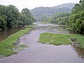
The Greenbrier River in Marlinton


See also
 In Spanish: Marlinton (Virginia Occidental) para niños
