
Greenbrier River Trail facts for kids
Quick facts for kids Greenbrier River Rail Trail State Park |
|
|---|---|

Greenbrier River Trail south of Marlinton
|
|

Greenbrier River Rail Trail State Park
Location in West Virginia
|
|
| Location | Greenbrier County, West Virginia and Pocahontas County, West Virginia |
| Nearest town | Marlinton, West Virginia |
| Elevation | 2,116 ft (645 m) |
| Established | 1980 |
| Named for | Greenbrier River |
| Governing body | West Virginia Division of Natural Resources |
The Greenbrier River Trail (GRT) is a special kind of park in West Virginia. It's a long, narrow state park that follows an old railroad track. This trail stretches for about 77.1-mile (124.1 km) (that's like 124 kilometers!) between the towns of North Caldwell and Cass.
The trail was originally built for trains by the Chesapeake and Ohio Railway. It was used to carry people and goods. But after the Great Depression in the 1930s, fewer trains used the line. In the late 1970s, the land was given to the State of West Virginia. It was then turned into a fun trail for everyone to enjoy in 1980.
The Greenbrier River Trail is great for many activities. You can go hiking, bicycling, skiing, or even horseback riding. The path is made of crushed limestone, which makes it smooth and easy to use. It's even friendly for wheelchairs! There are 14 places where you can get onto the trail.
Along the way, you'll find 16 simple campsites. Some even have cool three-sided shelters for camping. There are also many picnic tables for a nice outdoor meal. The trail goes through three state parks and two state forests. As you follow the Greenbrier River, the trail gently slopes downhill from north to south. You'll cross 35 bridges and go through two tunnels! One tunnel is called Droop Mountain Tunnel, and it's about 409 feet (125 m) long. The other is Sharps Tunnel, which is about 500 feet (150 m) long.
The Greenbrier River Trail has won some big awards. In 1999, it was named a Millennium Legacy Trail. This means it's a very important trail for the future. In 2012, it joined the National Rail Trail Hall of Fame. Backpacker magazine also called it "one of the Top 10 hiking trails in the United States."
History of the Greenbrier River Trail
The Greenbrier River Trail follows parts of an old railroad line. This line was built by the Chesapeake and Ohio Railway. It was finished between 1899 and 1900. The railway was very busy in the 1920s. It connected to another railway and helped move goods. These goods included stone from quarries, wood from sawmills, and leather from tanneries. Farmers also used it to transport their crops and animals. The busiest year for the railway was 1926.
After the 1930s, fewer trains used the line. This was because new roads were built, and many trees had been cut down. Passenger trains stopped running on January 8, 1958. Freight trains stopped in December 1978. The railway officially closed on December 29, 1978.
The Chesapeake and Ohio Railway gave most of this old railway land to West Virginia. This happened on June 20, 1980. The state then turned it into the Greenbrier River Trail. Some of the old tracks were even used by the Cass Scenic Railroad.
Trail Access Points
You can get onto the Greenbrier River Trail at many different points. These are called trailheads. Each trailhead has parking for visitors. Here is a list of some of the main trailheads:
| Trailhead | Milepost | Directions | Map Coordinates |
|---|---|---|---|
| North Caldwell | 3.0 | About 1.3 mi (2.1 km) north of US 60 on Stone House Road | 37°47′37″N 80°22′50″W / 37.79361°N 80.38056°W |
| Harper | 5.8 | On County Road 30/3 | |
| Keister | 11.1 | On County Road 30/1 | |
| Anthony | 14.4 | On County Road 21/2 | |
| Spring Creek | 21.4 | On County Road 13, about 3.5 mi (5.6 km) east of US 219 | |
| Renick | 24.5 | On Auto Road (County Road 11), about 0.4 mi (0.64 km) east of US 219 | |
| Horrock | 29.6 | On Rorer Road (County Road 7/2) | |
| Beard | 38.5 | On Beard Post Office Road (County Road 31/8) | |
| Burnsides | 41.7 | On Workman Road (County Road 31/3) | |
| Seebert | 45.8 | At Seebert on Seebert Road (County Road 27), about 2 miles (3.2 km) east of US 219 | 38°07′36″N 80°10′33″W / 38.12667°N 80.17583°W |
| Marlinton | 56.0 | At Marlinton on WV 39 | 38°13′18″N 80°05′39″W / 38.22167°N 80.09417°W |
| Cass | 80.4 | At Slabtown, about 0.5 mi (0.80 km) south of Cass on WV 66 at Deer Creek Road | 38°23′27″N 79°55′20″W / 38.39083°N 79.92222°W |
Images for kids
-
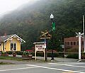
Marlinton trailhead
-
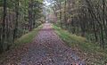
Straight shady section of trail
-
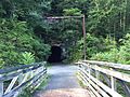
Southern entrance to Sharps Tunnel


