
U.S. Route 60 in West Virginia facts for kids
Quick facts for kids
|
||||
|---|---|---|---|---|
| Midland Trail | ||||
|
US 60 highlighted in red
|
||||
| Route information | ||||
| Maintained by WVDOH | ||||
| Length | 177.8 mi (286.1 km) | |||
| Existed | 1926–present | |||
| Major junctions | ||||
| West end | ||||
|
||||
| East end | ||||
| Location | ||||
| Counties: | Wayne, Cabell, Putnam, Kanawha, Fayette, Greenbrier | |||
| Highway system | ||||
| United States Numbered Highways List • Bannered • Divided • Replaced West Virginia Routes
|
||||

U.S. Route 60 (or US 60) is a major road that travels across the middle and southern parts of West Virginia. It starts at the Kentucky state line near Catlettsburg, Kentucky, and Kenova. The road then goes through important cities like Huntington, Charleston, and White Sulphur Springs.
After passing White Sulphur Springs, US 60 leaves West Virginia and enters Virginia. For part of this journey, it shares the road with Interstate 64 (I-64). A large part of US 60 in West Virginia is also known as the Midland Trail. This section is even marked with signs as a National Scenic Byway, which means it's a special road with beautiful views.
Contents
What is U.S. Route 60?
US 60 is a long highway that crosses the United States. The part we are talking about is in West Virginia. It's about 177.8 miles (286.1 kilometers) long in this state. The road was officially created in 1926. It connects many towns and cities, helping people travel and move goods.
The Midland Trail: A Scenic Journey

The Midland Trail is a special part of US 60. It's a National Scenic Byway that runs through Southern West Virginia. This scenic route stretches for about 100 miles (160 kilometers). It goes from White Sulphur Springs in the east to Charleston in the west.
History of the Midland Trail
The Midland Trail follows an old path. People believe that buffalo and native peoples first carved this path into the mountains. Later, in 1790, George Washington ordered the trail to be cleared. This made it easier for people to travel.
Over time, the trail became an important road. Stagecoaches used it for travel, and soldiers traveled on it during the American Civil War. It was once part of a much longer trail that crossed the entire country.
The James River and Kanawha Turnpike
In this area, the Midland Trail follows the path of the historic James River and Kanawha Turnpike. This was an early road built to connect canals. These canals were on the James River in Virginia. They connected to the part of the Kanawha River in West Virginia where boats could travel.
Traveling the Midland Trail Today
The Midland Trail goes through some of the toughest mountain areas in West Virginia. Before 1988, many vehicles, including large trucks carrying coal and timber, used this road. But in 1988, a new section of I-64 was finished. This new interstate highway made travel much faster.
Because of the new interstate, less traffic uses the Midland Trail now. Today, it's mostly used by local drivers. It's also popular with "shunpikers." These are people who prefer to take a slower, more beautiful road instead of a busy highway. The trail offers a peaceful break from fast travel.
The road goes through the Kanawha River Valley and then climbs high up onto a plateau. Because of the sharp turns and steep hills, drivers of large vehicles like RVs should be careful. New drivers should also be extra cautious, especially when the weather is bad.
Important Road Connections
US 60 connects with many other important roads and interstates in West Virginia. These connections help people travel to different cities and regions.
- In Huntington, US 60 connects with US 52 and I-64.
- In South Charleston, it connects with I-64.
- In Charleston, US 60 meets US 119, I-64, and I-77.
- Near Hico, it crosses US 19.
- In Lewisburg, it connects with US 219.
- Near White Sulphur Springs, it connects with WV 92 and I-64.
These are just a few of the many roads that US 60 connects with as it travels across West Virginia.
Images for kids
-
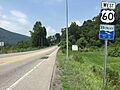
View west along US 60 at CR 60/14 departing White Sulphur Springs
-
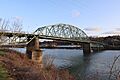
US 60 crossing the Kanawha River at the Patrick Street Bridge in Charleston
_at_Harts_Run_Road_(Greenbrier_County_Route_60-14)_in_White_Sulphur_Springs,_Greenbrier_County,_West_Virginia.jpg)

