
James River facts for kids
Quick facts for kids James River |
|
|---|---|

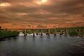
James River at the crossing of the Blue Ridge Parkway
|
|

A map of the James River drainage basin
|
|
| Native name | Powhatan (Powhatan) |
| Country | United States |
| State | Virginia |
| Physical characteristics | |
| Main source | Confluence of Cowpasture River and Jackson River Iron Gate, Allegheny Mountains, Virginia 37°47′4″N 79°46′33″W / 37.78444°N 79.77583°W |
| River mouth | Hampton Roads Chesapeake Bay, Virginia 36°56′30″N 76°26′37″W / 36.94167°N 76.44361°W |
| Length | 348 mi (560 km) |
| Basin features | |
| Basin size | 10,432 sq mi (27,020 km2) |
| Tributaries |
|

The James River is a very important river in Virginia, USA. It starts in the Appalachian Mountains and flows for about 348 miles (560 km) to the Chesapeake Bay. If you include the Jackson River, which is one of its starting points, it's even longer, at 444 miles (715 km). This makes it the longest river entirely within Virginia.
Many historic cities are located along the James River. These include Jamestown and Williamsburg, which were Virginia's first colonial capitals. Today, Richmond, the current capital, also sits on its banks. The river has played a huge role in Virginia's history and continues to be important today.
Contents
History of the James River
Early History and Naming
Before Europeans arrived, Native Americans lived along the river. They called it the Powhatan River, after the powerful Powhatan people who lived there.
In 1607, English colonists arrived and built the first permanent English settlement in the Americas at Jamestown. They renamed the river "James" after King James I of England. This settlement was about 35 miles (56 km) upstream from the Chesapeake Bay.
The River's Role in Colonial Virginia
For many years, the James River was like a major highway for the colonial Virginia. Ships from England used it to bring supplies and new settlers. At first, the colonists hoped to find gold, but they didn't send much valuable treasure back to England.
Then, in 1612, a businessman named John Rolfe started growing a new kind of tobacco. This tobacco became very popular in England. Soon, the river was used to export huge barrels of this "cash crop" from many plantations built along its banks. This made the colony financially successful and encouraged more people to invest and move there.
Many plantations had their own docks on the river. Important ports like City Point and Smithfield also grew along the James. The colonial capital, Jamestown, was also on the river.
Exploring the Upper River
The river was important for trade and settling the inner parts of Virginia. However, large ocean-going ships could not go past what is now Richmond. Smaller boats were used to transport goods like tobacco from the Piedmont and Great Valley regions down to seaports in Richmond and Manchester. Towns like Lynchburg and Buchanan became important stops along the river.
Canals and Railroads
People once thought the James River could be a route to transport goods from the Ohio Valley. So, they started building the James River and Kanawha Canal. This canal was meant to connect the James River to the Kanawha River, which flows into the Ohio River. For the very mountainous parts, they built the James River and Kanawha Turnpike for wagons.
However, before the canal was finished, railroads became a better way to transport goods. The Chesapeake and Ohio Railway (C&O) was completed in 1873, connecting Richmond to the Ohio River. This made the canal less useful. Later, a railroad line was built along the canal's path. Today, this rail line is mainly used to transport West Virginia coal to ports for export.
Cleaning Up the James River
In the 1960s and 1970s, a chemical called Kepone was accidentally released into the James River. This caused pollution, and parts of the river were considered unsafe. Fishing was banned for 13 years, which hurt many businesses.
Since the 1970s, the James River has become much healthier. In 1983, leaders from Maryland, Virginia, Pennsylvania, and Washington D.C. signed an agreement to protect the Chesapeake Bay. This led to the Chesapeake Bay Program, which helps clean up the bay and its rivers, including the James.
The James River Association (JRA), started in 1976, also works to improve the river. Their reports show that the river's health has greatly improved. In 2023, they gave the James River a "B" grade, showing how far it has come from its unhealthy past.
Where Does the James River Flow?

The James River drains a large area of about 10,432 square miles (27,019 km²). This area is called its watershed. About 2.5 million people live in this watershed.
The James River starts near Iron Gate, where the Cowpasture and Jackson rivers meet in the Appalachian Mountains. It then flows into the Chesapeake Bay at Hampton Roads. The river's tides reach as far west as Richmond, where the river meets its fall line (the point where boats can no longer travel upstream).
Major Tributaries
Many smaller rivers and streams flow into the James River. These are called tributaries. Some of the larger ones that flow into the tidal part of the river include:
At its mouth, near Newport News, the Elizabeth River and the Nansemond River join the James River. Together, they form the harbor known as Hampton Roads. From Hampton Roads, a channel leads into the southern part of the Chesapeake Bay and then out to the Atlantic Ocean. Many ships use this river to bring in and send out products from Virginia.
- Appomattox River
- Chickahominy River
- Warwick River
- Pagan River
- Nansemond River
- Looney Creek
- Cowpasture River
- Jackson River
- Craig Creek
- Catawba Creek
- Maury River
Fun Activities on the James River

The James River is a great place for outdoor fun! Many parks and attractions are found along its banks. During the summer, people enjoy activities like canoeing, fishing, kayaking, hiking, and swimming.
From the Blue Ridge mountains to Richmond, the river has many rapids and calm pools. These are perfect for fishing and whitewater rafting. The most exciting whitewater section is a 2-mile (3.2 km) stretch that ends right in downtown Richmond. This is unique because you can see tall buildings while experiencing Class III rapids (or Class IV when the water is high!).
East of Richmond, where the river is wider and calmer, it's great for water skiing and other large boat activities. The river is also known for its large blue catfish, which often weigh 20 to 30 pounds (9 to 14 kg), and sometimes even over 50 pounds (23 kg)!
The James River is also home to the rare Atlantic sturgeon. These large fish can grow over 5 feet (1.5 meters) long. In 2007, about 175 sturgeon were found in the entire river, showing how important it is to protect this special species.
Bridges Over the James River
The James River has many bridges, especially in the Hampton Roads area where it can be up to 5 miles (8 km) wide. Because large ships travel upriver to the Port of Richmond, these bridges need to be very tall or include tunnels or drawbridges.
Major Bridges Below Richmond
Here are some of the important highway crossings from east to west in the Hampton Roads area:
- The Hampton Roads Bridge-Tunnel (I-64)
- The Monitor-Merrimac Memorial Bridge-Tunnel (I-664)
- The James River Bridge (US 17/ US 258/ VA 32)
- The Jamestown Ferry (VA 31) – This is a free ferry that carries cars and people.
- The Benjamin Harrison Memorial Bridge – This is a drawbridge that can open to let ships pass.
- The Varina-Enon Bridge – This is a very tall cable-stayed bridge that carries I-295.
- The Vietnam Veterans Memorial Bridge – This high bridge carries the Pocahontas Parkway (State Route 895).
The Vietnam Veterans Memorial Bridge is the last high bridge before the Deepwater Port of Richmond. West of this point, bridges are designed more for flood control than for ship clearance.
Bridges in Richmond
Many highway bridges cross the James River within the city of Richmond:
- Interstate 95 James River Bridge (I-95)
- Mayo Bridge (US-360)
- Manchester Bridge (US-60)
- Robert E. Lee Memorial Bridge (US-1, US-301)
- Boulevard Bridge (VA-161) – This is a toll bridge.
- Powhite Parkway Bridge (Powhite Parkway and VA-76) – This is also a toll bridge.
- Huguenot Memorial Bridge (VA-147)
- Edward E. Willey Bridge (VA-150)
Bridges West of Richmond
There are also many bridges further west of Richmond, including:
- World War II Veterans Memorial Bridge (SR 288)
- U.S. Route 522 near Maidens
- U.S. Route 15 near Bremo Bluff
- U.S. Route 60 at Bent Creek
- Monacan Bridge (U.S. Route 29 east of Lynchburg)
- Carter Glass Memorial Bridge (U.S. Route 29 Business at Lynchburg)
- John Lynch Memorial Bridge (Lynchburg)
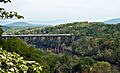
- Blue Ridge Parkway near Big Island
- U.S. Route 501 at Snowden
- U.S. Route 11 at Buchanan
- Interstate 81 at Buchanan
- U.S. Route 220 near Iron Gate
Bicycles on Bridges
Some bridges, like the Monitor-Merrimac Memorial Bridge-Tunnel, do not allow bicycles. However, bicyclists can use the Jamestown Ferry. In Richmond, bicycles are required to use the sidewalk on the Boulevard Bridge for safety.
James River Reserve Fleet

The James River is home to a special group of ships called the "James River fleet" or "ghost fleet." These are part of the National Defense Reserve Fleet. These ships are "mothballed" which means they are kept ready but not actively used. Most are merchant vessels, like cargo ships.
These ships can be quickly activated, usually within 20 to 120 days. They are used to provide shipping for the United States during emergencies, such as military needs or commercial shipping problems. The fleet is managed by the U.S. Department of Transportation's Maritime Administration and is based near Fort Eustis, Virginia. It's different from the United States Navy reserve fleets, which are made up of warships.
Images for kids
-
ACL Railroad crossing at the falls in Richmond.
-
Amtrak's Northeast Regional crosses near Lynchburg.
-
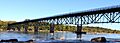
Boulevard Bridge in Richmond


See also
 In Spanish: Río James (Virginia) para niños
