Iron Gate, Virginia facts for kids
Quick facts for kids
Iron Gate, Virginia
|
|
|---|---|

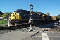
A CSX freight train passes through Iron Gate in 2007.
|
|
| Nickname(s):
IG
|
|
| Motto(s):
Gateway to the Alleghany Highlands
|
|

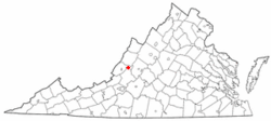
Location of Iron Gate, Virginia
|
|
| Country | United States |
| State | Virginia |
| County | Alleghany |
| Government | |
| • Type | Mayor–council |
| Area | |
| • Total | 0.35 sq mi (0.90 km2) |
| • Land | 0.33 sq mi (0.86 km2) |
| • Water | 0.02 sq mi (0.05 km2) |
| Elevation | 1,037 ft (316 m) |
| Population
(2020)
|
|
| • Total | 324 |
| • Density | 926/sq mi (360.0/km2) |
| Time zone | UTC-5 (Eastern (EST)) |
| • Summer (DST) | UTC-4 (EDT) |
| ZIP Code |
24448
|
| Area code(s) | 540 and 826 |
| FIPS code | 51-40024 |
| GNIS feature ID | 1493127 |
Iron Gate is a small town located in the eastern part of Alleghany County, Virginia, in the United States. In 2020, about 324 people lived here. The town is found along U.S. Route 220, close to another town called Clifton Forge.
Contents
The Story of Iron Gate: A Town's Past
The town of Iron Gate officially became a town in 1889. Its beginning was strongly linked to the "Iron Age." This was a time when iron was very important for making tools and buildings.
In the 1880s, companies started opening iron mines in Alleghany County. The Alleghany Iron and Ore Company built a large furnace in the northern part of Iron Gate. This location was perfect because it was close to the railroad. Many people worked for this company until it closed down in 1919.
Where is Iron Gate? Exploring its Geography
Iron Gate is located at 37°47′55″N 79°47′28″W / 37.79861°N 79.79111°W.
The town covers a total area of about 0.3 square miles (0.9 square kilometers). All of this area is land. An interesting fact is that the James River begins its journey right here in Iron Gate.
What's the Weather Like?
The weather in Iron Gate usually has mild changes between high and low temperatures. There is also enough rain throughout the year. According to the Köppen Climate Classification system, Iron Gate has a marine west coast climate. This type of climate is often shown as "Cfb" on climate maps.
Who Lives in Iron Gate? Population Changes Over Time
| Historical population | |||
|---|---|---|---|
| Census | Pop. | %± | |
| 1890 | 199 | — | |
| 1900 | 392 | 97.0% | |
| 1910 | 600 | 53.1% | |
| 1920 | 699 | 16.5% | |
| 1930 | 777 | 11.2% | |
| 1940 | 719 | −7.5% | |
| 1950 | 725 | 0.8% | |
| 1960 | 716 | −1.2% | |
| 1970 | 692 | −3.4% | |
| 1980 | 620 | −10.4% | |
| 1990 | 417 | −32.7% | |
| 2000 | 404 | −3.1% | |
| 2010 | 388 | −4.0% | |
| 2020 | 324 | −16.5% | |
| Source: U.S. Census Bureau | |||
This table shows how the number of people living in Iron Gate has changed over many years. You can see that the population was highest in the 1930s and has slowly decreased since then.
The 2020 Census: A Snapshot of the Town
In 2020, a census (a count of the population) showed that 324 people lived in Iron Gate. There were 170 homes in the town.
The census also looked at the different groups of people living there:
- About 87.3% of the people were White.
- About 5.2% were African American or Black.
- A small number were American Indian (0.3%) or Asian (0.3%).
- About 6.8% of the people were from two or more races.
- About 1.5% of the population were Hispanic or Latino.
How People Make a Living: Iron Gate's Economy
Iron Gate is mostly a "bedroom community." This means that many people who live in Iron Gate travel to nearby towns like Clifton Forge and Covington for work.
One important business in town is Garten Trucking. This company has a large terminal and warehouse where trucks are managed and goods are stored.
Fun Things to Do: Recreation in Iron Gate
The Virginia Department of Wildlife Resources has a special spot where people can get to the James River. This spot is just south of Iron Gate.
This access point is one of twelve that make up the Upper James River Water Trail. This "blueway" is like a path on the water, perfect for kayaking, canoeing, and other water activities along the James River.
Learning in Iron Gate: Education
Students in Iron Gate attend schools run by Alleghany County Public Schools.
- Younger students go to Sharon Elementary School.
- Middle school students attend Covington Middle School (since 2023).
- Older students go to Alleghany High School.
For students who want to continue their education after high school, Mountain Gateway Community College is nearby in Clifton Forge.
Getting Around: Transportation
By Air
The closest small airport for private planes is Ingalls Field, near Hot Springs. For bigger planes and commercial flights, the closest airports are the Greenbrier Valley Airport and the Roanoke-Blacksburg Regional Airport.
By Road
By Rail
The CSX company operates the James River Subdivision train line, which passes through Iron Gate. If you want to catch a passenger train, the closest station is in Clifton Forge.
See also
 In Spanish: Iron Gate (Virginia) para niños
 | Dorothy Vaughan |
 | Charles Henry Turner |
 | Hildrus Poindexter |
 | Henry Cecil McBay |

