Alleghany County, Virginia facts for kids
Quick facts for kids
Alleghany County
|
||
|---|---|---|

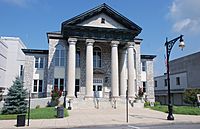
The Alleghany Courthouse in Covington.
|
||
|
||

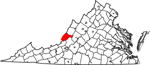
Location within the U.S. state of Virginia
|
||
 Virginia's location within the U.S. |
||
| Country | ||
| State | ||
| Founded | 1822 | |
| Named for | Allegheny Mountains | |
| Seat | Covington | |
| Largest town | Clifton Forge | |
| Area | ||
| • Total | 449.7 sq mi (1,165 km2) | |
| • Land | 446.572 sq mi (1,156.62 km2) | |
| • Water | 3.152 sq mi (8.16 km2) 0.7% | |
| Population
(2020)
|
||
| • Total | 15,223 | |
| • Density | 33.851/sq mi (13.0701/km2) | |
| Time zone | UTC−5 (Eastern) | |
| • Summer (DST) | UTC−4 (EDT) | |
| Congressional district | 6th | |
Alleghany County is a county in the western part of Virginia. It gets its name from the Allegheny Mountains that border it. The county is also the northernmost part of the Roanoke Region.
The main town, or county seat, is Covington. In 2020, about 15,223 people lived there. The county was created in 1822. It was formed from parts of other counties nearby.
Contents
History of Alleghany County
Alleghany County was officially started on January 5, 1822. This happened because the Virginia General Assembly passed a law. The new county was made from pieces of Bath County, Botetourt County, and Monroe County. Most people lived around the new county seat, Covington. The county was named after the Allegheny Mountains nearby.
In Virginia, some cities can be "independent cities." This means they are not part of any county. Covington is one of these cities. However, the town of Clifton Forge became part of Alleghany County again in 2001.
When the county was first formed, farmers grew a plant called hemp. This plant was used to make ropes in Richmond. Later, when the demand for hemp went down, farmers started growing grains and hay. They also raised livestock.
During the American Civil War, iron from a place called Longdale Furnace in the county was used. This iron helped build a famous ship called the CSS Virginia. Soldiers from Alleghany County were present at the end of the war.
Geography and Nature
Alleghany County covers about 449.7 square miles. Most of this area, 446.572 square miles, is land. The rest, about 3.152 square miles, is water. The county is located in the Ridge-and-Valley Appalachians area of Virginia. This region has many long, parallel ridges and valleys.
Alleghany County is also part of the Appalachian Regional Commission. This group works to help the Appalachian region grow.
Two important rivers, the Cowpasture River and Jackson River, flow through the county. These rivers join together just south of the county to form the James River.
Neighboring Counties
Alleghany County shares borders with these other counties:
- Bath County – to the north
- Rockbridge County – to the east
- Botetourt County – to the southeast
- Craig County – to the south
- Monroe County, West Virginia – to the southwest
- Greenbrier County, West Virginia – to the west
Protected Natural Areas
Parts of these protected areas are in Alleghany County:
- George Washington National Forest
- United States National Radio Quiet Zone
Population Over Time
| Historical population | |||
|---|---|---|---|
| Census | Pop. | %± | |
| 1830 | 2,816 | — | |
| 1840 | 2,749 | −2.4% | |
| 1850 | 3,515 | 27.9% | |
| 1860 | 6,765 | 92.5% | |
| 1870 | 3,674 | −45.7% | |
| 1880 | 5,586 | 52.0% | |
| 1890 | 9,283 | 66.2% | |
| 1900 | 16,330 | 75.9% | |
| 1910 | 14,173 | −13.2% | |
| 1920 | 15,332 | 8.2% | |
| 1930 | 20,188 | 31.7% | |
| 1940 | 22,688 | 12.4% | |
| 1950 | 23,139 | 2.0% | |
| 1960 | 12,128 | −47.6% | |
| 1970 | 12,461 | 2.7% | |
| 1980 | 14,333 | 15.0% | |
| 1990 | 13,176 | −8.1% | |
| 2000 | 12,926 | −1.9% | |
| 2010 | 16,250 | 25.7% | |
| 2020 | 15,223 | −6.3% | |
| U.S. Decennial Census 1790–1960 1900–1990 1990–2000 2010 2020 |
|||
In 2020, the total population of Alleghany County was 15,223 people.
Economy and Jobs
A big part of the county's economy comes from WestRock. This company runs a large paper mill in Covington. It is the second largest paper mill on the East Coast. WestRock also has another facility in Low Moor.
Alleghany County is close to popular resorts like The Homestead and The Greenbrier. Many residents also travel to nearby cities for work. These cities include Lewisburg, Lexington, and Roanoke.
Covington has its own baseball team called the Covington Lumberjacks. They play in the Valley Baseball League.
Getting Around
You can travel by train from the Clifton Forge station. This station is about 12 miles from Covington. Amtrak, the national passenger rail service, uses the Cardinal route here. Clifton Forge is also an important place for fueling trains for CSX Transportation.
Major roads like Interstate 64 (east-west) and U.S. 220 (north-south) pass through the area. These roads help trucks and other vehicles get around easily.
Main Highways
 I-64
I-64 US 60
US 60 US 220
 SR 18
SR 18 SR 42
SR 42 SR 159
 SR 311
Schools and Learning
Alleghany County has several schools for students.
- Alleghany High School serves grades 9–12.
- Covington Middle School serves grades 6–8.
- There are three elementary schools for pre-kindergarten to grade 5: Callaghan Elementary, Mountain View Elementary, and Sharon Elementary.
The county also has special learning centers:
- The Jackson River Governor's School, a Virginia state governors school.
- The Jackson River Technical Center, for technical training.
- Mountain Gateway Community College, for higher education.
Towns and Communities
Even though Covington is the county seat, it is an independent city. This means it is not officially part of Alleghany County.
See also
 In Spanish: Condado de Alleghany (Virginia) para niños
 | Audre Lorde |
 | John Berry Meachum |
 | Ferdinand Lee Barnett |


