
Bath County, Virginia facts for kids
Quick facts for kids
Bath County
|
|||||
|---|---|---|---|---|---|

Bath County Courthouse in Warm Springs
|
|||||
|
|||||

Location within the U.S. state of Virginia
|
|||||
 Virginia's location within the U.S. |
|||||
| Country | |||||
| State | |||||
| Founded | 1790 | ||||
| Named for | Bath, England | ||||
| Seat | Warm Springs | ||||
| Largest community | Hot Springs | ||||
| Area | |||||
| • Total | 535 sq mi (1,390 km2) | ||||
| • Land | 529 sq mi (1,370 km2) | ||||
| • Water | 5 sq mi (10 km2) 1.0% | ||||
| Population
(2020)
|
|||||
| • Total | 4,209 | ||||
| • Density | 7.867/sq mi (3.038/km2) | ||||
| Time zone | UTC−5 (Eastern) | ||||
| • Summer (DST) | UTC−4 (EDT) | ||||
| Congressional district | 6th | ||||


Bath County is a county in the state of Virginia. It's located on the western side of Virginia, in the Shenandoah Valley. In 2020, about 4,209 people lived here. This makes it one of the least populated counties in Virginia. The main town, or county seat, is Warm Springs.
Contents
History and How People Make a Living
Bath County was created on December 14, 1790. It was formed from parts of other counties nearby. The county got its name from the city of Bath in England. This is because Bath County has many natural mineral springs, just like the famous spa city in England.
In the early 1700s, people from different parts of Europe settled here. Many came from England, Scotland, Germany, and Ireland. By 1800, most people in Bath County were farmers. Some also worked as artisans or ran small shops.
Today, Bath County's economy mainly focuses on tourism and fun activities. The biggest employer is The Omni Homestead. This is a historic hotel and resort in Hot Springs. It was first built in 1766. You can also go camping and fishing at Lake Moomaw in the southern part of the county.
The county is also home to the Bath County Pumped Storage Station. This is a special power plant that uses water to create electricity. It's a type of hydroelectric plant.
Nature and Environment
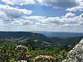
The Nature Conservancy owns over 9,000 acres (about 36 square kilometers) of forest in Bath County. This area is called the Warm Springs Mountain Preserve. It helps protect important natural places in the Appalachian Mountains.
You can find rare "pine barrens" here. These are like small, dwarfed forests. In Virginia, they are only known to grow on Warm Springs Mountain.
Geography and Location
Bath County covers about 535 square miles (1,386 square kilometers). Most of this area, about 529 square miles (1,370 square kilometers), is land. Only about 5 square miles (13 square kilometers) is water.
A large part of Bath County, about 89%, is covered in forest. About half of this forest is part of the George Washington National Forest. Another 6% is in Douthat State Park.
Bath County is located right on the border with West Virginia. It has several small towns and villages. The most famous ones are Hot Springs and Warm Springs. They are known for their natural mineral springs. Did you know Bath County is the only county in Virginia without a traffic light?
Neighboring Counties
- Highland County – to the north
- Augusta County – to the northeast
- Rockbridge County – to the east
- Alleghany County – to the south
- Greenbrier County, West Virginia – to the southwest
- Pocahontas County, West Virginia – to the west
Protected Natural Areas
- George Washington National Forest (part of it is in Bath County)
- United States National Radio Quiet Zone (part of it is in Bath County)
Main Roads
 US 220
 SR 39
SR 39 SR 42
SR 42
Population Information
The population of Bath County has changed over the years. Here's a look at how many people have lived here during different census counts:
| Historical population | |||
|---|---|---|---|
| Census | Pop. | %± | |
| 1800 | 5,508 | — | |
| 1810 | 4,837 | −12.2% | |
| 1820 | 5,237 | 8.3% | |
| 1830 | 4,002 | −23.6% | |
| 1840 | 4,300 | 7.4% | |
| 1850 | 3,486 | −18.9% | |
| 1860 | 3,676 | 5.5% | |
| 1870 | 3,795 | 3.2% | |
| 1880 | 4,482 | 18.1% | |
| 1890 | 4,587 | 2.3% | |
| 1900 | 5,595 | 22.0% | |
| 1910 | 6,538 | 16.9% | |
| 1920 | 6,389 | −2.3% | |
| 1930 | 8,137 | 27.4% | |
| 1940 | 7,191 | −11.6% | |
| 1950 | 6,296 | −12.4% | |
| 1960 | 5,335 | −15.3% | |
| 1970 | 5,192 | −2.7% | |
| 1980 | 5,860 | 12.9% | |
| 1990 | 4,799 | −18.1% | |
| 2000 | 5,048 | 5.2% | |
| 2010 | 4,731 | −6.3% | |
| 2020 | 4,209 | −11.0% | |
| U.S. Decennial Census 1790-1960 1900-1990 1990-2000 2010 2020 |
|||
2020 Census Details
The 2020 census showed the different groups of people living in Bath County.
| Race / Ethnicity (NH = Non-Hispanic) | Pop 2010 | Pop 2020 | % 2010 | % 2020 |
|---|---|---|---|---|
| White alone (NH) | 4,363 | 3,941 | 92.22% | 91.26% |
| Black or African American alone (NH) | 213 | 114 | 4.50% | 2.71% |
| Native American or Alaska Native alone (NH) | 5 | 3 | 0.11% | 0.07% |
| Asian alone (NH) | 7 | 17 | 0.15% | 0.40% |
| Pacific Islander alone (NH) | 0 | 1 | 0.00% | 0.02% |
| Some Other Race alone (NH) | 5 | 4 | 0.11% | 0.10% |
| Mixed Race or Multi-Racial (NH) | 37 | 156 | 0.78% | 3.71% |
| Hispanic or Latino (any race) | 101 | 73 | 2.13% | 1.73% |
| Total | 4,731 | 4,209 | 100.00% | 100.00% |
Education
Bath County has two elementary schools for students from pre-kindergarten to seventh grade. It also has one high school for grades 8 through 12. Around 555 students attend schools in the county.
Media
The Recorder is the local newspaper for Bath, Highland, and the Allegheny Highlands region of Virginia. Its offices are in Monterey and Mitchelltown.
Communities
Main Towns
Other Small Communities
Famous People From Bath County
- Custer LaRue – a soprano singer
- Creigh Deeds – a Virginia Senator
- Jailyn Ford – a professional softball pitcher
- Dan Ingalls – a computer scientist
- John Phillips – an NFL football player
- Sam Snead – a professional golfer
Images for kids
-
Warm Springs Valley

See also
 In Spanish: Condado de Bath (Virginia) para niños
