
Ridge-and-Valley Appalachians facts for kids
The Ridge-and-Valley Appalachians are a special part of the larger Appalachian Mountains. You can also call them the Ridge and Valley Province. This area stretches like a big arc from southeastern New York through New Jersey, Pennsylvania, Maryland, West Virginia, Virginia, Kentucky, Tennessee, Georgia, and Alabama.
This region is famous for its long, straight ridges with long, flat valleys in between them. Imagine a giant, wavy blanket with lots of parallel folds! These valleys were home to Native American groups for thousands of years. For example, the Cherokee people lived along many rivers in what is now Tennessee. The Catawba people lived near the Catawba River in North Carolina.
Traveling across the Ridge-and-Valley Appalachians has always been tough. Even today, with modern roads, it's a challenge to go from east to west. Long ago, when people traveled by walking or on horses, it was a huge barrier. Early European-American settlers found it very hard to move west to places like the Ohio Country. They mostly used rivers for travel because crossing the mountains was so difficult. Only a few special paths, like Cumberland Gap and Braddock's Road, helped people get through. Later, these paths became some of America's first major roads.
Contents
Where are the Ridge-and-Valley Appalachians?
The Ridge-and-Valley region starts on its eastern side with the Great Appalachian Valley. This valley is just west of the Blue Ridge Mountains. On the western side, you'll find steep cliffs and edges like the Allegheny Front and the Cumberland Mountains. So, the Valley and Ridge area sits right next to the Blue Ridge Mountains on their western side.
How were the Ridge-and-Valley Appalachians formed?

These interesting mountains were formed a very long time ago. They are what's left of an ancient area where rocks were pushed and folded. This happened during a huge mountain-building event called the Alleghenian orogeny. During this time, layers of rock were folded westward. They were also pushed over each other along massive breaks in the Earth's crust called thrust faults.
The ridges you see today are made of strong rocks that resist erosion. The valleys are where softer rocks have worn away. Smaller streams and rivers have carved their paths along these softer, more easily eroded rocks.
However, some big rivers, like the Delaware River, the Susquehanna River, the New River, and the Potomac River, are older than the mountains themselves. They cut right through the hard rock ridges, creating what are called water gaps. This happened because the whole region was once much flatter. The rivers flowed freely over soft dirt. Then, the land slowly lifted up, and the rivers were strong enough to keep cutting down through the rising rock, keeping their original paths.
Valleys can be shaped in different ways. Some are synclinal valleys, which means they are shaped like a U or a bowl. Others are anticlinal valleys, which means they were originally shaped like an upside-down U, but the top has eroded away.
The mountains are tallest and most developed in central Pennsylvania. This is sometimes called the Pennsylvania climax.
Important Ridges from North to South
Here are some of the well-known ridges in the Ridge-and-Valley Appalachians, listed from north to south:
| Name | State |
|---|---|
| Shawangunk Ridge | New York |
| Kittatinny Mountain | New Jersey |
| Bald Eagle Mountain | Pennsylvania |
| Blue Mountain | Pennsylvania |
| Jacks Mountain | Pennsylvania |
| Moosic Mountains | Pennsylvania |
| Nittany Mountain | Pennsylvania |
| Tuscarora Mountain | Pennsylvania |
| Tussey Mountain | Pennsylvania |
| Wills Mountain | Pennsylvania and Maryland |
| Sideling Hill | West Virginia, Maryland, and Pennsylvania |
| Cacapon Mountain | West Virginia |
| Knobly Mountain | West Virginia |
| Mill Creek Mountain | West Virginia |
| New Creek Mountain | West Virginia |
| North Fork Mountain | West Virginia |
| Patterson Creek Mountain | West Virginia |
| Sleepy Creek Mountain | West Virginia |
| South Branch Mountain | West Virginia |
| Spruce Knob | West Virginia |
| Allegheny Mountain | Virginia and West Virginia |
| Great North Mountain | Virginia and West Virginia |
| North Mountain | Virginia and West Virginia |
| Shenandoah Mountain | Virginia and West Virginia |
| Massanutten Mountain | Virginia |
| Pine Mountain | Kentucky, Virginia, and Tennessee |
| Clinch Mountain | Tennessee and Virginia |
| Powell Mountain | Tennessee and Virginia |
| Bays Mountain | Tennessee |
| House Mountain | Tennessee |
| Sharp's Ridge | Tennessee |
| Taylor Ridge (Georgia) | Georgia |
| White Oak Mountain | Tennessee and Georgia |
| Missionary Ridge | Tennessee and Georgia |
| Stringer's Ridge | Tennessee |
| Lookout Mountain | Tennessee, Georgia, and Alabama |
| Red Mountain | Alabama |
Photo gallery
-
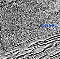
A map showing the Cumberland Plateau and Ridge and Valley Appalachians near the Virginia/West Virginia border.
-
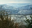
The ridge country in Pennsylvania, seen from Clarks Knob.
-
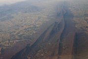
An aerial view of Massanutten Mountain, looking southwest. You can see the south fork of the Shenandoah River and part of the Blue Ridge Mountains.
-
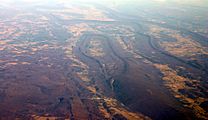
An aerial view of central Bedford County, Pennsylvania, in December 2006. It shows Wills, Evitts, and Tussey Mountains.


Images for kids
-
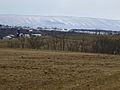
Blue Mountain in the Lehigh Valley region of Pennsylvania.
.jpg)
See also
 In Spanish: Valley and Ridge para niños
