Evitts Mountain facts for kids
Quick facts for kids Evitts Mountain |
|
|---|---|

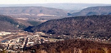
Water gaps cut by the Raystown Branch of the Juniata River through Evitts Mountain and Tussey Mountain (background), looking east from Kinton Knob.
|
|
| Highest point | |
| Elevation | 2,560+ ft (780 m) |
| Prominence | 1,280 ft (390 m) |
| Geography | |
| Location | Bedford County, Pennsylvania / Allegany County, Maryland, U.S. |
| Parent range | Ridge-and-Valley Appalachians |
| Topo map | USGS Bedford |
| Climbing | |
| Easiest route | Hike |
Evitts Mountain is a long, narrow mountain ridge. It is part of the Appalachian Mountains in the United States. This mountain stretches across Bedford County, Pennsylvania, and Allegany County, Maryland. It is known for its unique shape and natural beauty.
Contents
Where is Evitts Mountain?
Evitts Mountain is a long, narrow mountain. It is part of the Ridge and Valley region of the Appalachian Mountains. You can find it in Bedford County, Pennsylvania, and Allegany County, Maryland.
The mountain ridge starts in Maryland at Rocky Gap State Park. It then crosses the Mason–Dixon line into Pennsylvania. This famous line separates Pennsylvania from Maryland. The ridge continues north, passing near Tussey Mountain.
The mountain then turns west. It wraps around the north side of Bedford, Pennsylvania. It meets Dunning Mountain there. This area divides two valleys: Dunning Cove and Morrisons Cove.
A special place called "The Narrows" is on Evitts Mountain. Here, the Raystown Branch Juniata River cuts through the mountain. This creates a "water gap." The Pennsylvania Turnpike also passes through this gap.
Evitts Creek flows at the base of the mountain. You can find this creek in Rocky Gap State Park.
How Evitts Mountain Got Its Name
The Story of Mr. Evart
Evitts Mountain is named after an early pioneer. This person lived in the area a long time ago. Some people believe his last name was "Evart." Other spellings like Evett, Evert, and Evit have also been suggested.
In the 1780s, Mr. Evart chose to live alone. He went to the top of what is now Evitts Mountain. This spot is in Rocky Gap State Park. It was a quiet place, far from other people.
Mr. Evart's Homestead
At the top of the mountain, there is a place said to be Mr. Evart's old home. The mountain is about 2,000-foot (610 m) high. Every day, Mr. Evart would hike a steep trail. This trail was about 3.5-mile (5.6 km) long. Today, this path is called Evitts Trail. Some records suggest that Mr. Evart might have passed away before 1749.
 | Misty Copeland |
 | Raven Wilkinson |
 | Debra Austin |
 | Aesha Ash |

