Raystown Branch Juniata River facts for kids
Quick facts for kids Raystown Branch Juniata River |
|
|---|---|

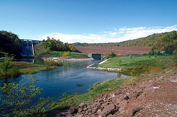
Raystown Lake Dam on the Raystown Branch Juniata River
|
|
|
Location of the mouth of Raystown Branch Juniata River
|
|
| Other name(s) | Tributary to Juniata River |
| Country | United States |
| State | Pennsylvania |
| Counties | Huntingdon County Bedford County |
| Physical characteristics | |
| Main source | divide between Raystown Branch and Wills Creek about 1 mile east of Macdonaldton, Pennsylvania 2,720 ft (830 m) 39°54′57″N 078°53′00″W / 39.91583°N 78.88333°W |
| River mouth | Juniata River Ardenheim, Pennsylvania 600 ft (180 m) 40°27′17″N 077°58′39″W / 40.45472°N 77.97750°W |
| Length | 62.14 mi (100.00 km) |
| Basin features | |
| Progression | generally north |
| River system | Juniata River |
| Basin size | 961.96 square miles (2,491.5 km2) |
| Tributaries |
|
| Waterbodies | Raystown Lake |
The Raystown Branch Juniata River is a major river in south-central Pennsylvania, United States. It is the longest and largest stream that flows into the Juniata River.
This river starts high up in the mountains, specifically along the Allegheny Front in Somerset County. From there, it travels about 123 miles (198 km) until it joins the main Juniata River near Huntingdon. Along its journey, the river flows past towns like Bedford and Everett.
One of the most important features of the Raystown Branch Juniata River is Raystown Lake. This huge lake is formed by the United States Army Corps of Engineers' Raystown Dam. It is the largest lake in Pennsylvania and is located about 5.4 miles (8.7 km) upstream from where the river meets the Juniata River.
Contents
The River's Journey
The Raystown Branch Juniata River begins its path at an elevation of about 2,720 feet (829 meters). This is high up in the mountains! It then flows generally north, making its way through different landscapes.
Where the River Ends
The river's journey finishes when it flows into the Juniata River near a place called Ardenheim, Pennsylvania. At this point, the elevation is much lower, around 600 feet (180 meters). This drop in elevation from its source helps the water flow downhill.
Raystown Lake: A Big Reservoir
Raystown Lake is a very important part of the river. It was created by building a large dam across the river. This lake helps control floods, provides clean drinking water, and is a popular spot for outdoor activities. Many people visit Raystown Lake for boating, fishing, and camping.
Bridges Over the River
Many bridges have been built over the Raystown Branch Juniata River to help people cross it. These bridges connect communities and make travel easier. Some of these bridges are quite old and have interesting designs.
- The Diehls Covered Bridge is a historic covered bridge that crosses the river in Harrison Township.
- Another bridge, the Bridge in Snake Spring Township, also crosses the river in Snake Spring Township.
- The Corbin Bridge is found crossing the river in Juniata Township.
Smaller Streams Joining the River
Like most rivers, the Raystown Branch Juniata River is fed by many smaller streams and creeks. These are called tributaries. They bring water from the surrounding land into the main river, making it bigger and stronger as it flows downstream. The river's basin, which is the area of land that drains into it, covers about 962 square miles (2,490 square kilometers).
 | John T. Biggers |
 | Thomas Blackshear |
 | Mark Bradford |
 | Beverly Buchanan |


