
Huntingdon County, Pennsylvania facts for kids
Quick facts for kids
Huntingdon County
|
|||
|---|---|---|---|

Jacks Mountain viewed from Shirleysburg
|
|||
|
|||

Location within the U.S. state of Pennsylvania
|
|||
 Pennsylvania's location within the U.S. |
|||
| Country | |||
| State | |||
| Founded | September 20, 1787 | ||
| Named for | Selina Hastings, Countess of Huntingdon | ||
| Seat | Huntingdon | ||
| Largest borough | Huntingdon | ||
| Area | |||
| • Total | 889 sq mi (2,300 km2) | ||
| • Land | 875 sq mi (2,270 km2) | ||
| • Water | 15 sq mi (40 km2) 1.6% | ||
| Population
(2020)
|
|||
| • Total | 44,092 | ||
| • Density | 50/sq mi (20/km2) | ||
| Time zone | UTC−5 (Eastern) | ||
| • Summer (DST) | UTC−4 (EDT) | ||
| Congressional district | 13th | ||


Huntingdon County is a county located in the state of Pennsylvania. In 2020, about 44,092 people lived there. The main town and county seat is Huntingdon.
The county was formed on September 20, 1787. It was mostly made from the northern part of Bedford County. Some land from Cumberland County was also added. Huntingdon County is part of the Southwest Pennsylvania region.
Contents
Huntingdon County Geography
Huntingdon County covers a total area of 889 square miles. Most of this area, 875 square miles, is land. The remaining 15 square miles (1.6%) is water.
The county has a humid continental climate. This means it has warm summers and cold winters. Average monthly temperatures in Huntingdon town range from about 28°F in January to 72°F in July.
Huntingdon County is part of a larger area called "Greater Appalachia." This region is known for its unique culture and history.
Natural Features to Explore
- Raystown Lake is a large lake popular for boating and fishing.
- Tussey Mountain is a mountain ridge that runs through the county.
Neighboring Counties
Huntingdon County shares borders with several other counties:
- Centre County (north)
- Mifflin County (east)
- Juniata County (east)
- Franklin County (southeast)
- Fulton County (south)
- Bedford County (southwest)
- Blair County (west)
People of Huntingdon County
The population of Huntingdon County has changed over the years. Here's how it has grown:
| Historical population | |||
|---|---|---|---|
| Census | Pop. | %± | |
| 1790 | 7,558 | — | |
| 1800 | 13,008 | 72.1% | |
| 1810 | 14,778 | 13.6% | |
| 1820 | 20,142 | 36.3% | |
| 1830 | 27,145 | 34.8% | |
| 1840 | 35,484 | 30.7% | |
| 1850 | 24,786 | −30.1% | |
| 1860 | 28,100 | 13.4% | |
| 1870 | 31,251 | 11.2% | |
| 1880 | 33,954 | 8.6% | |
| 1890 | 35,751 | 5.3% | |
| 1900 | 34,650 | −3.1% | |
| 1910 | 38,304 | 10.5% | |
| 1920 | 39,848 | 4.0% | |
| 1930 | 39,021 | −2.1% | |
| 1940 | 41,836 | 7.2% | |
| 1950 | 40,872 | −2.3% | |
| 1960 | 39,457 | −3.5% | |
| 1970 | 39,108 | −0.9% | |
| 1980 | 42,253 | 8.0% | |
| 1990 | 44,164 | 4.5% | |
| 2000 | 45,586 | 3.2% | |
| 2010 | 45,913 | 0.7% | |
| 2020 | 44,092 | −4.0% | |
| U.S. Decennial Census 1790-1960 1900-1990 1990-2000 2010-2017 |
|||
In 2010, there were 45,913 people living in Huntingdon County. There were 17,280 households. The county had about 52 people per square mile.
Most people in the county were White (92.50%). About 5.21% were Black or African American. Other groups included Native American, Asian, and Pacific Islander people. About 1.58% of the population was Hispanic or Latino.
Many people in Huntingdon County have German (33.9%), American (17.1%), or Irish (11.1%) backgrounds. English (7.5%) and Italian (5.7%) ancestry are also common.
Households and Age Groups
Out of 16,759 households, 30.10% had children under 18 living there. Most households (58.10%) were married couples. About 25.80% of households were individuals living alone.
The average household had 2.44 people. The average family had 2.92 people.
The population was spread out by age. About 21.70% were under 18. About 10.10% were 18 to 24 years old. People aged 25 to 44 made up 29.40% of the population. The median age was 38 years.
Languages Spoken
Most people in Huntingdon County speak English. The local way of speaking English is called the Central Pennsylvania accent.
In some parts of the county, like Kishacoquillas Valley, many Amish and Mennonite people live. They often speak a German language called Pennsylvania Dutch.
2020 Census Overview
The 2020 census showed the following racial makeup for Huntingdon County:
| Race | Num. | Perc. |
|---|---|---|
| White (NH) | 39,420 | 89.4% |
| Black or African American (NH) | 2,267 | 5.14% |
| Native American (NH) | 49 | 0.11% |
| Asian (NH) | 210 | 0.47% |
| Pacific Islander (NH) | 9 | 0.02% |
| Other/Mixed (NH) | 1,285 | 3% |
| Hispanic or Latino | 852 | 2% |
Huntingdon, PA Micropolitan Area
Huntingdon County is known as the Huntingdon, PA Micropolitan Statistical Area (μSA). This means it's a smaller urban area with a central city and surrounding communities.
In 2010, this micropolitan area had 45,913 people. It was the 11th most populated micropolitan area in Pennsylvania.
Education in Huntingdon County

Huntingdon County offers many educational options for students. These include public schools, charter schools, private schools, and colleges.
Public School Districts
Students in Huntingdon County attend schools in several public school districts:
- Huntingdon Area School District
- Juniata Valley School District
- Mount Union Area School District (also in Mifflin County)
- Southern Huntingdon County School District
- Tussey Mountain School District (also in Bedford County)
- Tyrone Area School District (also in Blair and Centre Counties)
Other Education Centers
- Huntingdon County Career and Technology Center: This center in Mill Creek helps students learn job skills.
- Tuscarora Intermediate Unit 11: This organization supports local schools.
Charter Schools
Charter schools are public schools that have more freedom in how they operate.
- New Day Charter School (grades 7–12): Located in Huntingdon.
- Stone Valley Community Charter School (grades K–5): Located in McAlevy's Fort.
Private Schools
Private schools in the county include:
- Calvary Christian Academy: Huntingdon
- Class School: Mill Creek
- Grier School: Birmingham
- Huntingdon Christian Academy: Huntingdon
- Huntingdon County Child & Adult Development Center
- Meadow Green Mennonite School: Three Springs
- Shavers Creek Christian School: Petersburg
- West Penn F Grace Brethren: Saxton
- Woodcock Valley Center on Children: Huntingdon
Colleges and Universities
- Juniata College: A small, independent college in Huntingdon.
- Pennsylvania Highlands Community College: Has a center in Walker Township.
Libraries
Local libraries provide resources for learning and reading:
- Huntingdon County Library
- Memorial Public Library of the Borough of Alexandria
- Mount Union Community Library
Transportation in Huntingdon County
Major roads help people travel through Huntingdon County.

 I-76 / Penna Turnpike
 US 22
US 22 US 522
 PA 26
PA 26
PA 26 Truck PA 35
PA 35 PA 45
PA 45 PA 103
 PA 305
 PA 350
 PA 453
 PA 475
 PA 550
 PA 641
 PA 655
 PA 747
 PA 829
 PA 913
 PA 994
Media in Huntingdon County
Residents of Huntingdon County can stay informed through various media.
Radio Stations
AM Stations
- ESPN RADIO 1150 AM: Huntingdon (Sports)
- WIEZ 670 AM: Lewistown (News/Talk)
- WMAJ 1450 AM: State College (Sports)
- WVAM 1430 AM: Altoona (Sports)
- WFBG 1290 AM: Altoona (News/Talk)
FM Stations
- WHUN 103.5 FM: Huntingdon (Oldies)
- WDBF 106.3 FM: Selinsgrove (Country)
- WKVR 92.3 FM: Huntingdon (College)
- W273BE 102.5 FM: Huntingdon (Public Radio)
- WFGY 98.1 FM: Altoona (Country)
Newspapers
- The Daily News: A local newspaper for the county.
Television Channels
- CBS: WTAJ-TV, Altoona
- ABC: WATM-TV, Johnstown
- Fox: WWCP-TV, Johnstown
- NBC: WJAC-TV, Johnstown
- PBS: WPSU-TV, State College
- CW: WPKD-TV, Jeannette
Communities of Huntingdon County

Huntingdon County has different types of communities. These include boroughs, townships, and other smaller places.
Boroughs
Boroughs are like small towns with their own local governments.
Townships
Townships are larger areas that often include rural land and smaller communities.
- Barree
- Brady
- Carbon
- Cass
- Clay
- Cromwell
- Dublin
- Franklin
- Henderson
- Hopewell
- Jackson
- Juniata
- Lincoln
- Logan
- Miller
- Morris
- Oneida
- Penn
- Porter
- Shirley
- Smithfield
- Springfield
- Spruce Creek
- Tell
- Todd
- Union
- Walker
- Warriors Mark
- West
- Wood
Census-Designated Places (CDPs)
CDPs are areas identified by the U.S. Census Bureau for statistical purposes. They are not officially incorporated towns.
Unincorporated Communities
These are smaller places that are not officially part of a borough or CDP.
- Calvin
- Entriken
- Nossville
Population Ranking of Communities (2010)
This table shows the population of the largest communities in Huntingdon County based on the 2010 census. † county seat
| Rank | City/Town/etc. | Municipal type | Population (2010 Census) |
|---|---|---|---|
| 1 | † Huntingdon | Borough | 7,093 |
| 2 | Mount Union | Borough | 2,447 |
| 3 | McConnellstown | CDP | 1,194 |
| 4 | Allenport | CDP | 648 |
| 5 | Petersburg | Borough | 480 |
| 6 | Broad Top City | Borough | 452 |
| 7 | Three Springs | Borough | 444 |
| 8 | Mapleton | Borough | 441 |
| 9 | Orbisonia | Borough | 428 |
| 10 | Rockhill | Borough | 371 |
| T-11 | Alexandria | Borough | 346 |
| T-11 | Saltillo | Borough | 346 |
| 12 | Mill Creek | Borough | 328 |
| 13 | Marklesburg | Borough | 204 |
| 14 | Dudley | Borough | 184 |
| 15 | Shirleysburg | Borough | 150 |
| 16 | Cassville | Borough | 143 |
| 17 | Coalmont | Borough | 106 |
| 18 | Shade Gap | Borough | 105 |
| 19 | Birmingham | Borough | 90 |
Notable People from Huntingdon County
Many interesting people have connections to Huntingdon County:
- Scott Beatty (born 1969): An author and comic book writer. He was raised in Petersburg.
- Hugh Brady (1768–1851): A U.S. Army general. He was born in Standingstone.
- Martin Grove Brumbaugh (1862–1930): He served as the 26th Governor of Pennsylvania.
- Dylan Lane (born 1977): A game show host, known for hosting Chain Reaction. He spent his life in Huntingdon.
- Horace Porter (1837–1921): A Civil War general and a US diplomat.
- John Purdue (1802–1876): The main person who helped start Purdue University. He was born in Huntingdon County.
- Robert Elliott Speer (1867–1947): An important American religious leader.
Images for kids
-
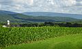
Jacks Mountain viewed from Shirleysburg
-
Flag of Huntingdon County, Pennsylvania
-
Seal of Huntingdon County, Pennsylvania
See also
 In Spanish: Condado de Huntingdon (Pensilvania) para niños
