Shade Gap, Pennsylvania facts for kids
Quick facts for kids
Shade Gap, Pennsylvania
|
|
|---|---|
|
Borough
|
|

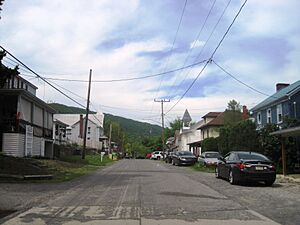
Northbound Main Street in Shade Gap
|
|

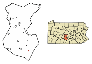
Location of Shade Gap in Huntingdon County, Pennsylvania.
|
|
| Country | United States |
| State | Pennsylvania |
| County | Huntingdon |
| Government | |
| • Type | Borough Council |
| Area | |
| • Total | 0.03 sq mi (0.08 km2) |
| • Land | 0.03 sq mi (0.08 km2) |
| • Water | 0.00 sq mi (0.00 km2) |
| Elevation | 1,007 ft (307 m) |
| Population
(2010)
|
|
| • Total | 105 |
| • Estimate
(2019)
|
89 |
| • Density | 2,781.25/sq mi (1,087.39/km2) |
| Time zone | UTC-5 (Eastern (EST)) |
| • Summer (DST) | UTC-4 (EDT) |
| ZIP Code |
17255
|
| Area code(s) | 814 |
| FIPS code | 42-69456 |
| GNIS feature ID | 1215279 |
| Local phone exchanges: 259 | |
Shade Gap is a small community located in Huntingdon County, Pennsylvania, United States. It's known as a borough, which is a type of town with its own local government. In 2010, about 105 people lived there. Shade Gap is a quiet place surrounded by nature.
Contents
Exploring Shade Gap's Location
Shade Gap is found in the southeastern part of Huntingdon County. It sits right at the base of a mountain called Shade Mountain. Just south of the mountain, there's a special spot called a "water gap." This is where Shade Creek flows through a narrow opening in the mountain. The entire borough is surrounded by Dublin Township.
How to Get to Shade Gap
Several roads help people travel to and from Shade Gap. U.S. Route 522 passes just east of the borough. If you go north on this road, you'll reach Mount Union in about 16 miles. If you head south, you'll find Interstate 76 near Fort Littleton in about 12 miles.
Pennsylvania Route 35 also runs northeast along the base of Shade Mountain for about 37 miles, leading to Mifflin. Another road, Pennsylvania Route 641, goes southeast over Tuscarora Mountain for about 9 miles to Spring Run.
Shade Gap's Size
According to the U.S. Census Bureau, the borough of Shade Gap is quite small. It covers a total area of about 0.08 square kilometers, which is all land.
Understanding Shade Gap's Population
The number of people living in Shade Gap has changed over the years. Here's a look at how the population has grown and shrunk:
| Historical population | |||
|---|---|---|---|
| Census | Pop. | %± | |
| 1880 | 170 | — | |
| 1890 | 209 | 22.9% | |
| 1900 | 138 | −34.0% | |
| 1910 | 143 | 3.6% | |
| 1920 | 136 | −4.9% | |
| 1930 | 130 | −4.4% | |
| 1940 | 156 | 20.0% | |
| 1950 | 157 | 0.6% | |
| 1960 | 140 | −10.8% | |
| 1970 | 186 | 32.9% | |
| 1980 | 141 | −24.2% | |
| 1990 | 113 | −19.9% | |
| 2000 | 97 | −14.2% | |
| 2010 | 105 | 8.2% | |
| 2019 (est.) | 89 | −15.2% | |
| Sources: | |||
Who Lives in Shade Gap?
In 2000, there were 97 people living in Shade Gap, making up 38 households and 25 families. Most of the people were White (97.94%), with a small percentage of African American residents (2.06%).
The community had 38 households. About 31.6% of these households had children under 18 living with them. More than half (52.6%) were married couples. The average household had about 2.55 people, and the average family had about 3.08 people.
Age Groups in the Borough
The population in Shade Gap was spread out across different age groups. About 25.8% of the residents were under 18 years old. Around 30.9% were between 25 and 44, which is often the working age. About 18.6% were 65 or older. The average age in the borough was 36 years old.
Income and Economy
In 2000, the average income for a household in Shade Gap was $18,125 per year. For families, the average income was $23,438. The average income per person in the borough was $9,557. About 19.5% of the population, including 20% of those under 18, lived below the poverty line.
See also
 In Spanish: Shade Gap para niños
 | Misty Copeland |
 | Raven Wilkinson |
 | Debra Austin |
 | Aesha Ash |


